
فائل:China county-level divisions and administrative divisions (PRoC claim).png

ایس وکھالے دا ناپ: ۷۵۹ × ۶۰۰ پکسلز۔ دوجے ریزولوشنز: ۳۰۴ × ۲۴۰ پکسلز | ۶۰۷ × ۴۸۰ پکسلز | ۹۷۲ × ۷۶۸ پکسلز | ۱,۲۸۰ × ۱,۰۱۲ پکسلز | ۲,۵۶۰ × ۲,۰۲۳ پکسلز | ۶,۲۴۶ × ۴,۹۳۷ پکسلز ۔
اصل فائل (۶,۲۴۶ × ۴,۹۳۷ پکسلز, فائل حجم: ۱.۵۴ میگابائٹ, MIME type: image/png)

.png)

|
This image is expected to always be the most recent one. Feel free to update it when needed.
|

|
This file may be updated to reflect new information. If you wish to use a specific version of the file without new updates being mirrored, please upload the required version as a separate file. |
خلاصہ
| تفصیل |
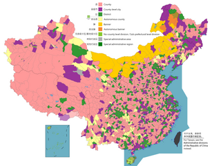
English: Map of China, shows counties, county-level cities, county-level districts, autonomous counties and banners, banners, etc.
日本語: 中国の地図は、郡、郡レベルの都市、郡レベルの地区、自治県とバナー、バナーなどを示しています。
Русский: Карта Китая, показывает уезды, города уездного уровня, уездные районы, автономные уезды и баннеры, баннеры и т. Д.
中文(简体):中国地图,显示县、县级市、县级区、自治县和旗、自治旗等。
中文(繁體):中國地圖,顯示縣、縣級市、縣級區、自治縣和旗、自治旗等。 |
||
| تریخ |
|
||
| سروت |
Legend: English:
County
County-level city
County-level district
Autonomous county
Banner
Autonomous banner
No county-level division / Sub-prefectural level division
Special district
Special administrative region 中文(简体): 县
县级市
县级区
自治县
旗
自治旗
无县级/副地级
特区
特别行政区 |
||
| لکھاری |
|
||
| اجازت (فائل نوں دوبارہ ورتنا) |
Map of China, administrative divisions: میں، اس کم دے کاپیرائٹ دا مالک، اس کم نوں اس لائسنس دے مطابق چھاپدا واں:
|
لائسنس –
میں، اس کم دے کاپیرائٹ دا مالک، اس کم نوں اس لائسنس دے مطابق چھاپدا واں:
This file is licensed under the Creative Commons Attribution-Share Alike 4.0 International license.
- تہانوں کھلھ اے:
- حصہ کرنا – کاپی، ونڈنا تے کم بھیجنا
- فیر رلانا – کم نوں فٹ کرنا
- تھلے دتیاں شرطاں نال:
- کس دے ناں – تسیں لازمی ایس کم دے بناں والے بارے دسو جنج اونے آکھیا اے یا جنج لسنس چ آکھیا گیا ہے۔
- اکو جہا شئیر کرو۔ – اگر تسیں بدلدے یا ایس کم تے بناندے تے بنن والے کم نوں اینج دے لسنس نال ای ونڈو گے۔

|
This map image could be re-created using vector graphics as an SVG file. This has several advantages; see Commons:Media for cleanup for more information. If an SVG form of this image is available, please upload it and afterwards replace this template with
{{vector version available|new image name}}.
It is recommended to name the SVG file “China county-level divisions and administrative divisions (PRoC claim).svg”—then the template Vector version available (or Vva) does not need the new image name parameter. |
| Annotations | This image is annotated: View the annotations at Commons |
فائل دی تریخ
فائل نو اس ویلے دی حالت وچ ویکھن واسطے تاریخ/ویلے تے کلک کرو۔
.png&dir=prev)
.png&offset=20220329005936)
.png&offset=&limit=20)
.png&offset=&limit=50)
.png&offset=&limit=100)
.png&offset=&limit=250)
.png&offset=&limit=500)
| تریخ تے ویلہ | نکی مورت | پاسے | ورتن والا | تیپّݨی کرو | |
|---|---|---|---|---|---|
| موجودہ | ۱۳:۵۹, ۱ اگست ۲۰۲۳ | | ۶,۲۴۶ × ۴,۹۳۷ (۱.۵۴ میگابائٹ) | Maanshen | Add Baiyang, update and fix Nanchang borders |
| ۱۳:۳۲, ۱ اگست ۲۰۲۳ |  | ۶,۲۴۶ × ۴,۹۳۷ (۱.۵۴ میگابائٹ) | Maanshen | Update: Tsona County -> Tsona City, Mainling County -> Mainling City | |
| ۱۷:۳۰, ۳۱ جولائی ۲۰۲۳ |  | ۶,۲۴۶ × ۴,۹۳۷ (۱.۴۱ میگابائٹ) | Baomi | ||
| ۲۱:۳۵, ۱۶ جولائی ۲۰۲۳ |  | ۶,۲۴۶ × ۴,۹۳۷ (۱.۵۹ میگابائٹ) | Josemite | That old nine-dashed line is badly drawn | |
| ۱۴:۵۲, ۱۷ فروری ۲۰۲۳ |  | ۶,۲۴۶ × ۴,۹۳۷ (۱.۵۵ میگابائٹ) | 孟天皓 | 修改香港区界 | |
| ۰۴:۰۶, ۳ اگست ۲۰۲۲ |  | ۶,۲۴۶ × ۴,۹۳۷ (۱.۵۵ میگابائٹ) | Maanshen | Update disputed/claimed borders, white with stroke is not claimed and filled in color is claimed | |
| ۰۵:۰۸, ۲۰ اپریل ۲۰۲۲ |  | ۶,۲۴۶ × ۴,۹۳۷ (۱.۵۴ میگابائٹ) | Maanshen | Fix borders between Ili's Kuytun, Huyanghe, and Karamay | |
| ۰۴:۴۱, ۲۰ اپریل ۲۰۲۲ |  | ۶,۲۴۶ × ۴,۹۳۷ (۱.۵۴ میگابائٹ) | Maanshen | Fix colors again in Honghe counties | |
| ۰۶:۴۵, ۳۱ مارچ ۲۰۲۲ |  | ۶,۲۴۶ × ۴,۹۳۷ (۱.۵۴ میگابائٹ) | Maanshen | Fix some colors | |
| ۰۵:۵۹, ۲۹ مارچ ۲۰۲۲ |  | ۶,۲۴۶ × ۴,۹۳۷ (۱.۵۴ میگابائٹ) | Maanshen | Fix colors in Shanxi with Fenyang and Xiaoyi |
فائل دی ورتوں
تھلے دتے گئے 1 صفحے اس فائل نال جُڑدے نیں
فائل ویاپک ورتوں
ایہہ دوجے وکیاں ایس فائل نوں ورتدے نیں –
- ar.wikipedia.org تے ورتوں
- ast.wikipedia.org تے ورتوں
- az.wikipedia.org تے ورتوں
- ca.wikipedia.org تے ورتوں
- ce.wikipedia.org تے ورتوں
- cs.wikipedia.org تے ورتوں
- de.wikipedia.org تے ورتوں
- en.wikipedia.org تے ورتوں
- es.wikipedia.org تے ورتوں
- fa.wikipedia.org تے ورتوں
- fi.wikipedia.org تے ورتوں
- fr.wikipedia.org تے ورتوں
- id.wikipedia.org تے ورتوں
- ja.wikipedia.org تے ورتوں
- mk.wikipedia.org تے ورتوں
- nl.wikipedia.org تے ورتوں
- no.wikipedia.org تے ورتوں
- ru.wikipedia.org تے ورتوں
- sv.wikipedia.org تے ورتوں
- th.wikipedia.org تے ورتوں
- tr.wikipedia.org تے ورتوں
- uk.wikipedia.org تے ورتوں
- ur.wikipedia.org تے ورتوں
- vi.wikipedia.org تے ورتوں
- www.wikidata.org تے ورتوں
- zh.wikipedia.org تے ورتوں
ایس فائل دا ویکھو ہور جگت ورتن .
.png)
.png)