
فائل:Countries by immigrant population.svg

Size of this PNG preview of this SVG file: ۸۰۰ × ۴۱۰ پکسلز. دوجے ریزولوشنز: ۳۲۰ × ۱۶۴ پکسلز | ۶۴۰ × ۳۲۸ پکسلز | ۱,۰۲۴ × ۵۲۵ پکسلز | ۱,۲۸۰ × ۶۵۷ پکسلز | ۲,۵۶۰ × ۱,۳۱۳ پکسلز | ۱,۰۳۵ × ۵۳۱ پکسلز ۔
اصل فائل (ایس وی جی فائل، پکسل:۱,۰۳۵ × ۵۳۱، فائل سائز: ۱.۴۷ میگابائٹ)
خلاصہ
| تفصیل |
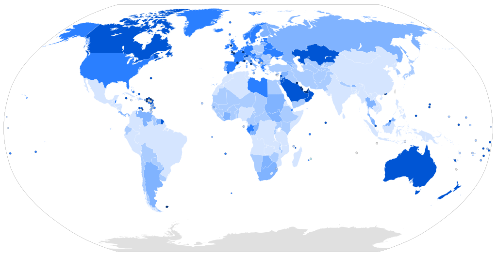
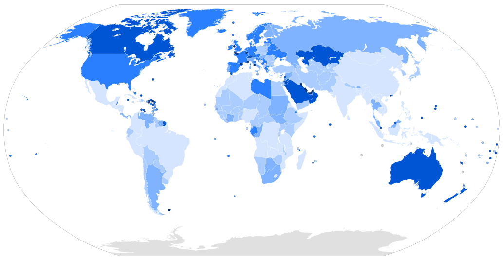
Map of the world with countries coloured according to their immigrant population as a percentage of the whole population, based on the UN's World Population Policies 2005 data ([1]). Legend: more than 50% 20% to 50% 10% to 20% 4% to 10% 1% to 4% less than 1% |
| تریخ | |
| سروت | Own work, derived from Image:BlankMap-World6.svg |
| لکھاری | Thebainer (Stephen Bain) |
| دوجے ورژن |
Derivative works of this file: Map of countries by percentage of immigrants.png File:Countries by immigrant population.png, raster version |
| SVG genesis |
لائسنس –
| I, Stephen Bain, hereby publish this work under the following licences: | ||
ایہ فائل ایس لسنس Creative Commons Attribution-Share Alike 3.0 Unported, 2.5 Generic, 2.0 Generic and 1.0 Generic نال چلدی اے۔
You may select the licence of your choice. |

فائل دی تریخ
فائل نو اس ویلے دی حالت وچ ویکھن واسطے تاریخ/ویلے تے کلک کرو۔
| تریخ تے ویلہ | نکی مورت | پاسے | ورتن والا | تیپّݨی کرو | |
|---|---|---|---|---|---|
| موجودہ | ۱۲:۱۵, ۱۶ مارچ ۲۰۱۷ | | ۱,۰۳۵ × ۵۳۱ (۱.۴۷ میگابائٹ) | TriadicRelation98 | Updated for 2015 |
| ۱۷:۴۴, ۱۱ مارچ ۲۰۰۷ |  | ۹۴۰ × ۴۷۷ (۲.۲۶ میگابائٹ) | Stephen Bain | ==Information== {{Information |Description=Map of the world with countries coloured according to their immigrant population as a percentage of the whole population, based on the UN's World Population Policies 2005 data ([http://www.u |
فائل دی ورتوں
تھلے دتے گئے 1 صفحے اس فائل نال جُڑدے نیں
فائل ویاپک ورتوں
ایہہ دوجے وکیاں ایس فائل نوں ورتدے نیں –
- ar.wikipedia.org تے ورتوں
- bg.wikipedia.org تے ورتوں
- da.wikibooks.org تے ورتوں
- de.wikipedia.org تے ورتوں
- en.wikipedia.org تے ورتوں
- fa.wikipedia.org تے ورتوں
- fi.wikipedia.org تے ورتوں
- hr.wikipedia.org تے ورتوں
- hu.wikipedia.org تے ورتوں
- id.wikipedia.org تے ورتوں
- is.wikipedia.org تے ورتوں
- it.wikipedia.org تے ورتوں
- lt.wikipedia.org تے ورتوں
- pl.wikipedia.org تے ورتوں
- pt.wikipedia.org تے ورتوں
- ru.wikipedia.org تے ورتوں
- sr.wikipedia.org تے ورتوں
- sr.wikinews.org تے ورتوں
- sv.wikipedia.org تے ورتوں
- ta.wikipedia.org تے ورتوں
- tr.wikipedia.org تے ورتوں
- ur.wikipedia.org تے ورتوں
- vec.wikipedia.org تے ورتوں
- zh.wikipedia.org تے ورتوں