
فائل:Cyprus districts named.png
اس توں وڈی مورت موجود نہیں۔
Cyprus_districts_named.png (۶۰۰ × ۳۶۵ پکسلز, فائل حجم: ۲۲ کلوبائٹ, MIME type: image/png)

|
This map image could be re-created using vector graphics as an SVG file. This has several advantages; see Commons:Media for cleanup for more information. If an SVG form of this image is available, please upload it and afterwards replace this template with
{{vector version available|new image name}}.
It is recommended to name the SVG file “Cyprus districts named.svg”—then the template Vector version available (or Vva) does not need the new image name parameter. |
خلاصہ
| تفصیل |
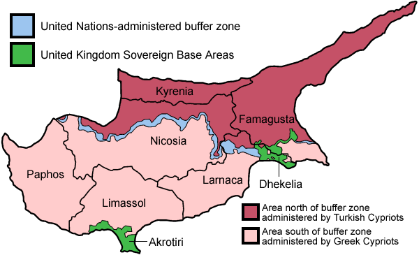
English: Map of the districts of Cyprus, named in English, with English annotations, and showing the Turkish Republic of Northern Cyprus, United Kingdom Sovereign Base Areas, and United Nations buffer zone. The individual maps see below.
Deutsch: Karte der Distrikte Zyperns: Bezirke der Republik Zypern, Türkische Republik Nordzypern, UK-Militärbasen, UN-Pufferzone (englische Beschriftung). Zu den Einzelkarten siehe unten "Individual maps". |
| تریخ | |
| سروت | آپݨا کم (traced from public domain UN or CIA maps.) |
| لکھاری | Golbez |
| دوجے ورژن |
Français : File:Carte des districts de Chypre.png
Ελληνικά: File:Cyprus districts named el.png
|
لائسنس –
میں، اس کم دے کاپیرائٹ دا مالک، اس کم نوں اس لائسنس دے مطابق چھاپدا واں:
ایس فائل نوں Creative Commons Attribution-Share Alike 2.5 Generic, 2.0 Generic and 1.0 Generic لسنس دتا گیا اے۔
- تہانوں کھلھ اے:
- حصہ کرنا – کاپی، ونڈنا تے کم بھیجنا
- فیر رلانا – کم نوں فٹ کرنا
- تھلے دتیاں شرطاں نال:
- کس دے ناں – تسیں لازمی ایس کم دے بناں والے بارے دسو جنج اونے آکھیا اے یا جنج لسنس چ آکھیا گیا ہے۔
- اکو جہا شئیر کرو۔ – اگر تسیں بدلدے یا ایس کم تے بناندے تے بنن والے کم نوں اینج دے لسنس نال ای ونڈو گے۔

|
کاپی کرن، ونڈن تے بدلن دی ایس ڈوکومنٹ لئی اجازت دتی جاندی اے ایہناں GNU Free Documentation License, Version 1.2 شرطاں نال یا مگروں کسے وی چھپے ورین Free Software Foundation توں بنا کسے انویرینٹ سیکشن دے، ناں فرنٹ کور لکھت تے ناں بیک کور لکھت دے۔ لسنس دی اک کاپی سیکشن وچ ہیگی اے جہدا ناں اے GNU Free Documentation License۔ |
| ایس فائل نوں کریٹو کامنز Attribution 2.5 پولینڈ لائسنس دتا گیا. | ||
| ||
| اس لائسنس دا ٹیگ GFDL دے مطابق اس فائل چ پایا گیا اے licensing update۔ |
تسیں اپنی مرضی دا لائسنس چݨ سکدے اوہ۔
Individual maps of the Cyprus districts
فائل دی تریخ
فائل نو اس ویلے دی حالت وچ ویکھن واسطے تاریخ/ویلے تے کلک کرو۔
| تریخ تے ویلہ | نکی مورت | پاسے | ورتن والا | تیپّݨی کرو | |
|---|---|---|---|---|---|
| موجودہ | ۰۱:۳۸, ۳۱ مئی ۲۰۱۰ | | ۶۰۰ × ۳۶۵ (۲۲ کلوبائٹ) | Wknight94 | Reverted to version as of 14:28, 13 August 2007 ---- latest upload with no new info on source, etc. |
| ۰۴:۴۶, ۱۸ نومبر ۲۰۰۸ |  | ۷۰۰ × ۴۸۲ (۹۴ کلوبائٹ) | Guntars strazdins | {{Information |Description= |Source= |Date= |Author= |Permission= |other_versions= }} | |
| ۰۴:۴۴, ۱۸ نومبر ۲۰۰۸ |  | ۷۰۰ × ۴۸۲ (۹۴ کلوبائٹ) | Guntars strazdins | {{Information |Description= |Source= |Date= |Author= |Permission= |other_versions= }} | |
| ۱۹:۲۸, ۱۳ اگست ۲۰۰۷ |  | ۶۰۰ × ۳۶۵ (۲۲ کلوبائٹ) | Lexicon | Reverted to earlier revision | |
| ۱۹:۲۸, ۱۳ اگست ۲۰۰۷ |  | ۶۰۰ × ۳۶۵ (۵۴ کلوبائٹ) | Lexicon | buffer zone and SBA colours flipped, since buffer zone is called the "Green Line" | |
| ۱۱:۰۷, ۳۰ جون ۲۰۰۵ |  | ۶۰۰ × ۳۶۵ (۲۲ کلوبائٹ) | Golbez | Got Dhekelia wrong again. Final version unless others have comments. | |
| ۰۷:۰۴, ۲۸ جون ۲۰۰۵ |  | ۶۰۰ × ۳۶۵ (۲۲ کلوبائٹ) | Golbez | Updated again, final version for now, cleaned up text and the Dhekelia area. | |
| ۲۲:۵۱, ۲۷ جون ۲۰۰۵ |  | ۶۰۰ × ۳۶۵ (۲۰ کلوبائٹ) | Golbez | Fixed a color | |
| ۲۲:۴۴, ۲۷ جون ۲۰۰۵ |  | ۶۰۰ × ۳۶۵ (۲۰ کلوبائٹ) | Golbez | Updated map with different color for north and south, and enclaves in Dhekelia. | |
| ۱۴:۴۸, ۲۷ جون ۲۰۰۵ |  | ۶۰۰ × ۳۶۵ (۱۹ کلوبائٹ) | Golbez | Map of the districts of Cyprus Source: Made by User:Golbez. {{cc-by-sa-2.0}} Category:Maps of Cyprus\ |
فائل دی ورتوں
تھلے دتے گئے 4 صفحے اس فائل نال جُڑدے نیں
فائل ویاپک ورتوں
ایہہ دوجے وکیاں ایس فائل نوں ورتدے نیں –
- af.wikipedia.org تے ورتوں
- ar.wikipedia.org تے ورتوں
- arz.wikipedia.org تے ورتوں
- az.wikipedia.org تے ورتوں
- az.wiktionary.org تے ورتوں
- be.wikipedia.org تے ورتوں
- bs.wikipedia.org تے ورتوں
- ca.wikipedia.org تے ورتوں
- Conflicte de Xipre
- Resolució 187 del Consell de Seguretat de les Nacions Unides
- Resolució 192 del Consell de Seguretat de les Nacions Unides
- Resolució 193 del Consell de Seguretat de les Nacions Unides
- Resolució 194 del Consell de Seguretat de les Nacions Unides
- Resolució 198 del Consell de Seguretat de les Nacions Unides
- Resolució 201 del Consell de Seguretat de les Nacions Unides
- Resolució 206 del Consell de Seguretat de les Nacions Unides
- Resolució 207 del Consell de Seguretat de les Nacions Unides
- Resolució 219 del Consell de Seguretat de les Nacions Unides
- Resolució 220 del Consell de Seguretat de les Nacions Unides
- Resolució 222 del Consell de Seguretat de les Nacions Unides
- Resolució 231 del Consell de Seguretat de les Nacions Unides
- Resolució 244 del Consell de Seguretat de les Nacions Unides
- Resolució 254 del Consell de Seguretat de les Nacions Unides
- Resolució 266 del Consell de Seguretat de les Nacions Unides
- Resolució 274 del Consell de Seguretat de les Nacions Unides
- Força de les Nacions Unides pel Manteniment de la Pau a Xipre
- Resolució 293 del Consell de Seguretat de les Nacions Unides
- Resolució 305 del Consell de Seguretat de les Nacions Unides
- Resolució 315 del Consell de Seguretat de les Nacions Unides
- Resolució 324 del Consell de Seguretat de les Nacions Unides
- Resolució 334 del Consell de Seguretat de les Nacions Unides
- Resolució 343 del Consell de Seguretat de les Nacions Unides
- Resolució 349 del Consell de Seguretat de les Nacions Unides
- Resolució 358 del Consell de Seguretat de les Nacions Unides
- Resolució 360 del Consell de Seguretat de les Nacions Unides
- Resolució 361 del Consell de Seguretat de les Nacions Unides
- Resolució 364 del Consell de Seguretat de les Nacions Unides
- Resolució 365 del Consell de Seguretat de les Nacions Unides
- Línia Verda (Xipre)
- Resolució 593 del Consell de Seguretat de les Nacions Unides
- Resolució 716 del Consell de Seguretat de les Nacions Unides
- Resolució 774 del Consell de Seguretat de les Nacions Unides
- Resolució 969 del Consell de Seguretat de les Nacions Unides
- Resolució 1475 del Consell de Seguretat de les Nacions Unides
- Resolució 1517 del Consell de Seguretat de les Nacions Unides
- ckb.wikipedia.org تے ورتوں
ایس فائل دا ویکھو ہور جگت ورتن .