
فائل:Danubemap.png
اس توں وڈی مورت موجود نہیں۔
Danubemap.png (۷۴۷ × ۴۸۰ پکسلز, فائل حجم: ۶۰۱ کلوبائٹ, MIME type: image/png)

|
This map image could be re-created using vector graphics as an SVG file. This has several advantages; see Commons:Media for cleanup for more information. If an SVG form of this image is available, please upload it and afterwards replace this template with
{{vector version available|new image name}}.
It is recommended to name the SVG file “Danubemap.svg”—then the template Vector version available (or Vva) does not need the new image name parameter. |
خلاصہ
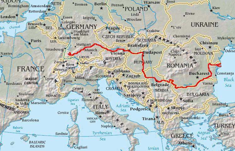
English: Map showing the flow of the Danube River. Uses the map of Europe from the CIA World Factbook.
لائسنس –
This image is in the public domain because it contains materials that originally came from the United States Central Intelligence Agency's World Factbook.
|
 |
فائل دی تریخ
فائل نو اس ویلے دی حالت وچ ویکھن واسطے تاریخ/ویلے تے کلک کرو۔
| تریخ تے ویلہ | نکی مورت | پاسے | ورتن والا | تیپّݨی کرو | |
|---|---|---|---|---|---|
| موجودہ | ۱۰:۳۴, ۱۲ فروری ۲۰۰۷ | | ۷۴۷ × ۴۸۰ (۶۰۱ کلوبائٹ) | Geologik | Map showing the flow of the Danube River. Uses the map of Europe from the CIA World Factbook. |
فائل دی ورتوں
تھلے دتے گئے 1 صفحے اس فائل نال جُڑدے نیں
فائل ویاپک ورتوں
ایہہ دوجے وکیاں ایس فائل نوں ورتدے نیں –
- ang.wikipedia.org تے ورتوں
- ast.wikipedia.org تے ورتوں
- av.wikipedia.org تے ورتوں
- azb.wikipedia.org تے ورتوں
- ban.wikipedia.org تے ورتوں
- be-tarask.wikipedia.org تے ورتوں
- bg.wikipedia.org تے ورتوں
ایس فائل دا ویکھو ہور جگت ورتن .