
فائل:Dengue06.png
ایس وکھالے دا ناپ: ۸۰۰ × ۴۳۵ پکسلز۔ دوجے ریزولوشنز: ۳۲۰ × ۱۷۴ پکسلز | ۶۴۰ × ۳۴۸ پکسلز | ۱,۱۶۱ × ۶۳۱ پکسلز ۔
اصل فائل (۱,۱۶۱ × ۶۳۱ پکسلز, فائل حجم: ۴۲ کلوبائٹ, MIME type: image/png)

|
This health map image could be re-created using vector graphics as an SVG file. This has several advantages; see Commons:Media for cleanup for more information. If an SVG form of this image is available, please upload it and afterwards replace this template with
{{vector version available|new image name}}.
It is recommended to name the SVG file “Dengue06.svg”—then the template Vector version available (or Vva) does not need the new image name parameter. |
خلاصہ
| تفصیل |
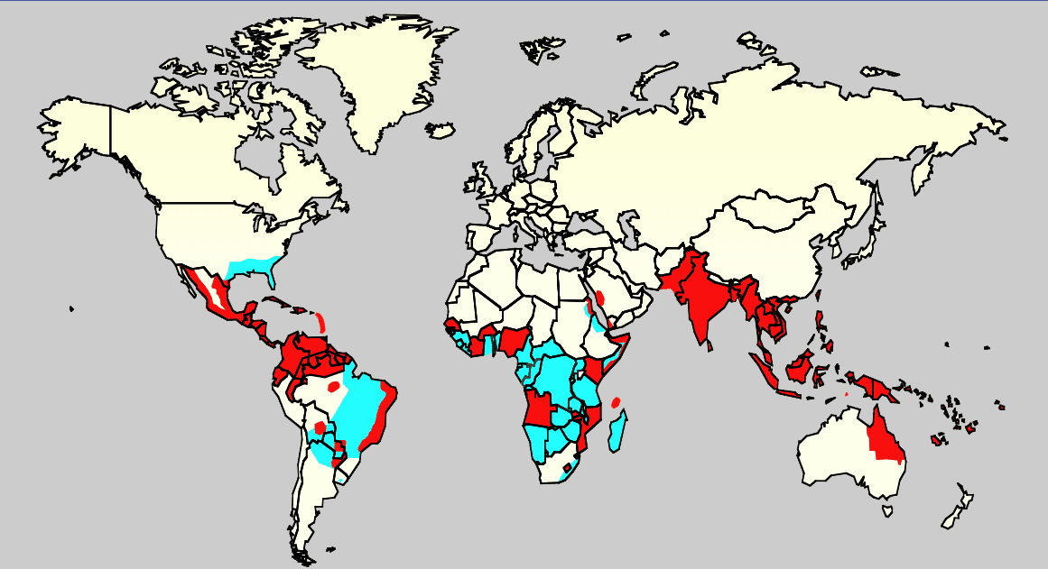
English: Map showing the distribution of dengue fever in the world, as of 2006. Map produced by the Agricultural Research Service of the US Department of Agriculture.
Key:
|
| سروت |
Own work using:
ReferenciasCeleste: Monday/OClubMorning/TRIServiceDENemergingJAX2007.ppt Áreas infectadas con el mosquito 'Aedes aegyptis Rojo: Áreas que estan infectadas con el mosquito Aedes Aegyptis y que tienen una reciente expansión epidémica. |
| لکھاری | Unknown author |
لائسنس –
This work is in the public domain in the United States because it is a work prepared by an officer or employee of the United States Government as part of that person’s official duties under the terms of Title 17, Chapter 1, Section 105 of the US Code.
Note: This only applies to original works of the Federal Government and not to the work of any individual U.S. state, territory, commonwealth, county, municipality, or any other subdivision. This template also does not apply to postage stamp designs published by the United States Postal Service since 1978. (See § 313.6(C)(1) of Compendium of U.S. Copyright Office Practices). It also does not apply to certain US coins; see The US Mint Terms of Use.
|
 | |
| ایہ فائل دے بارے چ دس اے جے اے کاپی حف دیاں روکاں توں کھلی اے تے نالدے رلدے حقاں توں وی۔ | ||
فائل دی تریخ
فائل نو اس ویلے دی حالت وچ ویکھن واسطے تاریخ/ویلے تے کلک کرو۔
| تریخ تے ویلہ | نکی مورت | پاسے | ورتن والا | تیپّݨی کرو | |
|---|---|---|---|---|---|
| موجودہ | ۰۵:۱۴, ۲۱ فروری ۲۰۱۶ | | ۱,۱۶۱ × ۶۳۱ (۴۲ کلوبائٹ) | Jahoe | Removed large chunk of irrelevant metadata, left behind by adobe editing software. No visible changes. |
| ۲۱:۲۶, ۱۸ دسمبر ۲۰۱۵ |  | ۱,۱۶۱ × ۶۳۱ (۶۳ کلوبائٹ) | Splette | Remove border between East and West Germany, as it has been united since 1990 (long before 2006) | |
| ۰۴:۳۴, ۳ جون ۲۰۰۷ |  | ۱,۱۶۱ × ۶۳۱ (۴۸ کلوبائٹ) | Aetheling | Map showing the distribution of dengue fever in the world, as of 2006. Map produced by the Agricultural Research Service of the US Department of Agriculture. Source: Slide #8 of a presentation by Gary G. Clark, PhD, entitled "Dengue: An emerging arbovira |
فائل دی ورتوں
تھلے دتے گئے 1 صفحے اس فائل نال جُڑدے نیں
فائل ویاپک ورتوں
ایہہ دوجے وکیاں ایس فائل نوں ورتدے نیں –
- ar.wikipedia.org تے ورتوں
- arz.wikipedia.org تے ورتوں
- ast.wikipedia.org تے ورتوں
- bn.wikipedia.org تے ورتوں
- ca.wikipedia.org تے ورتوں
- cs.wikipedia.org تے ورتوں
- cy.wikipedia.org تے ورتوں
- de.wikipedia.org تے ورتوں
- el.wikipedia.org تے ورتوں
- en.wikipedia.org تے ورتوں
- Natural hazards in Colombia
- Mosquito-borne disease
- User:Justthefacts1/Sandbox
- Dengue fever outbreaks
- Talk:Dengue fever/Archive 1
- Wikipedia:Wikipedia Signpost/2011-07-11/Featured content
- Wikipedia:WikiProject Medicine/Collaborative publication/Dengue fever
- Wikipedia:Wikipedia Signpost/2014-10-01/News and notes
- Wikipedia:Wikipedia Signpost/Single/2014-10-01
- Wikipedia:Wikipedia Signpost/Single/2011-07-11
- User:Notorious Biggles/Tobagoitis
- Wikipedia:WikiProject WikiFundi Content/Dengue fever
- es.wikipedia.org تے ورتوں
- es.wiktionary.org تے ورتوں
- eu.wikipedia.org تے ورتوں
- fa.wikipedia.org تے ورتوں
- fi.wikipedia.org تے ورتوں
- fr.wikipedia.org تے ورتوں
- ga.wikipedia.org تے ورتوں
- he.wikipedia.org تے ورتوں
- hi.wikipedia.org تے ورتوں
- hr.wikipedia.org تے ورتوں
- hu.wikipedia.org تے ورتوں
- hu.wikibooks.org تے ورتوں
- is.wikipedia.org تے ورتوں
- it.wikipedia.org تے ورتوں
- ja.wikipedia.org تے ورتوں
- la.wikipedia.org تے ورتوں
- ml.wikipedia.org تے ورتوں
- ms.wikipedia.org تے ورتوں
- nl.wikipedia.org تے ورتوں
- no.wikipedia.org تے ورتوں
- or.wikipedia.org تے ورتوں
ایس فائل دا ویکھو ہور جگت ورتن .