
فائل:DesertStormMap v2.svg

Size of this PNG preview of this SVG file: ۸۰۰ × ۵۶۳ پکسلز. دوجے ریزولوشنز: ۳۲۰ × ۲۲۵ پکسلز | ۶۴۰ × ۴۵۱ پکسلز | ۱,۰۲۴ × ۷۲۱ پکسلز | ۱,۲۸۰ × ۹۰۱ پکسلز | ۲,۵۶۰ × ۱,۸۰۲ پکسلز | ۱,۵۰۰ × ۱,۰۵۶ پکسلز ۔
اصل فائل (ایس وی جی فائل، پکسل:۱,۵۰۰ × ۱,۰۵۶، فائل سائز: ۳.۱۳ میگابائٹ)
|

خلاصہ
This W3C-unspecified vector image was created with Inkscape .
| سرلیکھ |
Operation Desert Storm |
||||
| Description |
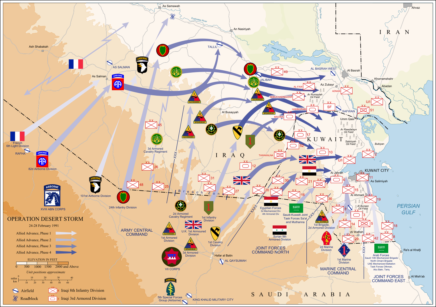
العربية: عملية عاصفة الصحراء، ضمن حرب الخليج الثانية، 24-28 شباط/ فبراير 1991.
English: Map of ground operations of Operation Desert Storm starting invasion February 24-28th 1991. Shows allied and Iraqi forces. Special arrows indicate the American 101st Airborne division moved by air and where the French 6st light division and American 3rd Armored Cavalry Regiment provided security.
Français : Carte montrant les opérations terrestres menées lors de l'opération Tempête du désert entre le 24 et le 28 février 1991 : les positions tenues par les armées irakienne et alliées, et les mouvements de cette dernière. Des flèches particulières indiquent les manœuvres héliportées pratiquées par la 101e division aéroportée, ainsi que les zones sécurisées par la 6e brigade légère blindée française et par le 3e régiment blindé de cavalerie américain. |
||||
| تریخ | (UTC) | ||||
| سروت | self-vectored from Image:Operation Desert Storm.jpg from this site and this site. | ||||
| Creator |
US Army |
||||
| Geotemporal data | |||||
| Date depicted | |||||
| Map location | Iraq/Kuwait border | ||||
| OpenStreetMap zoom level | 9 | ||||
| Bounding box |
|
||||
| Georeferencing | |||||
| Bibliographic data | |||||
| بولی | eng | ||||
| Archival data | |||||
| میڈیم | Inkscape SVG | ||||
| دوجے ورژن |
 |
||||

لائسنس –
This file is a work of a U.S. Army soldier or employee, taken or made as part of that person's official duties. As a work of the U.S. federal government, it is in the public domain in the United States.
|
 |
میں، اس کم دے کاپیرائٹ دا مالک، اس کم نوں اس لائسنس دے مطابق چھاپدا واں:

|
کاپی کرن، ونڈن تے بدلن دی ایس ڈوکومنٹ لئی اجازت دتی جاندی اے ایہناں GNU Free Documentation License, Version 1.2 شرطاں نال یا مگروں کسے وی چھپے ورین Free Software Foundation توں بنا کسے انویرینٹ سیکشن دے، ناں فرنٹ کور لکھت تے ناں بیک کور لکھت دے۔ لسنس دی اک کاپی سیکشن وچ ہیگی اے جہدا ناں اے GNU Free Documentation License۔ |
This file is licensed under the Creative Commons Attribution-Share Alike 4.0 International, 3.0 Unported, 2.5 Generic, 2.0 Generic and 1.0 Generic license.
- تہانوں کھلھ اے:
- حصہ کرنا – کاپی، ونڈنا تے کم بھیجنا
- فیر رلانا – کم نوں فٹ کرنا
- تھلے دتیاں شرطاں نال:
- کس دے ناں – تسیں لازمی ایس کم دے بناں والے بارے دسو جنج اونے آکھیا اے یا جنج لسنس چ آکھیا گیا ہے۔
- اکو جہا شئیر کرو۔ – اگر تسیں بدلدے یا ایس کم تے بناندے تے بنن والے کم نوں اینج دے لسنس نال ای ونڈو گے۔
تسیں اپنی مرضی دا لائسنس چݨ سکدے اوہ۔
فائل دی تریخ
فائل نو اس ویلے دی حالت وچ ویکھن واسطے تاریخ/ویلے تے کلک کرو۔
| تریخ تے ویلہ | نکی مورت | پاسے | ورتن والا | تیپّݨی کرو | |
|---|---|---|---|---|---|
| موجودہ | ۱۸:۱۴, ۹ جون ۲۰۱۲ | | ۱,۵۰۰ × ۱,۰۵۶ (۳.۱۳ میگابائٹ) | Coolland | uploaded with x-external-editor |
| ۰۹:۳۱, ۶ فروری ۲۰۰۸ |  | ۱,۵۰۰ × ۱,۰۵۶ (۳.۱۳ میگابائٹ) | Jeff Dahl | flags/label edits | |
| ۰۲:۰۰, ۵ فروری ۲۰۰۸ |  | ۱,۵۰۰ × ۱,۰۵۶ (۲.۸۹ میگابائٹ) | Jeff Dahl | == Summary == {{Inkscape}} {{Information |Description=Map of ground operations of Operation Desert Storm from February 24-28th 1991. Shows allied and Iraqi forces. |Source=self-made, vectored from Image:Operation Desert Storm.jpg from [http://www.his |
فائل دی ورتوں
تھلے دتے گئے 1 صفحے اس فائل نال جُڑدے نیں
فائل ویاپک ورتوں
ایہہ دوجے وکیاں ایس فائل نوں ورتدے نیں –
- an.wikipedia.org تے ورتوں
- ar.wikipedia.org تے ورتوں
- bg.wikipedia.org تے ورتوں
- br.wikipedia.org تے ورتوں
- ca.wikipedia.org تے ورتوں
- cs.wikipedia.org تے ورتوں
- de.wikipedia.org تے ورتوں
- el.wikipedia.org تے ورتوں
- en.wikipedia.org تے ورتوں
- French Foreign Legion
- Kuwait Armed Forces
- Armed Forces of Saudi Arabia
- 101st Airborne Division
- 82nd Airborne Division
- Gulf War
- 1st Cavalry Division (United States)
- 3rd Armored Division (United States)
- VII Corps (United States)
- 24th Infantry Division (United States)
- Norman Schwarzkopf Jr.
- 1st (United Kingdom) Division
- Air assault
- Battle of Khafji
- Royal Green Jackets (Rifles) Museum
- Iraqi invasion of Kuwait
- List of conflicts in Asia
- Opération Daguet
- Portal:Maps/Selected picture
- 1st Foreign Cavalry Regiment
- Wikipedia:WikiProject Iraq
- Wikipedia:Featured pictures thumbs/10
- Wikipedia:Featured picture candidates/February-2008
- Wikipedia:Featured picture candidates/Operation Desert Storm
- Wikipedia:Wikipedia Signpost/2008-02-18/Features and admins
- User talk:Jeff Dahl/Archive 3
- 82nd Sustainment Brigade
- Wikipedia:Featured pictures/Diagrams, drawings, and maps/Maps
- Wikipedia:WikiProject United States Government
- Wikipedia:Picture of the day/July 2008
- Template:POTD/2008-07-27
- User talk:Jeff Dahl/Archive 4
- Wikipedia:Wikipedia Signpost/2008-02-18/SPV
- Portal:Maps/Selected picture/38
- Wikipedia:WikiProject Military history/Showcase
- Wikipedia:WikiProject Military history/Showcase/FP
- 1st Brigade, 24th Infantry Division (United States)
ایس فائل دا ویکھو ہور جگت ورتن .