
فائل:Detailed SVG map of the Anglophone world.svg

Size of this PNG preview of this SVG file: ۸۰۰ × ۴۱۱ پکسلز. دوجے ریزولوشنز: ۳۲۰ × ۱۶۴ پکسلز | ۶۴۰ × ۳۲۹ پکسلز | ۱,۰۲۴ × ۵۲۶ پکسلز | ۱,۲۸۰ × ۶۵۷ پکسلز | ۲,۵۶۰ × ۱,۳۱۴ پکسلز ۔
اصل فائل (ایس وی جی فائل، پکسل:۲,۵۶۰ × ۱,۳۱۴، فائل سائز: ۱.۳۸ میگابائٹ)
خلاصہ
| تفصیل |
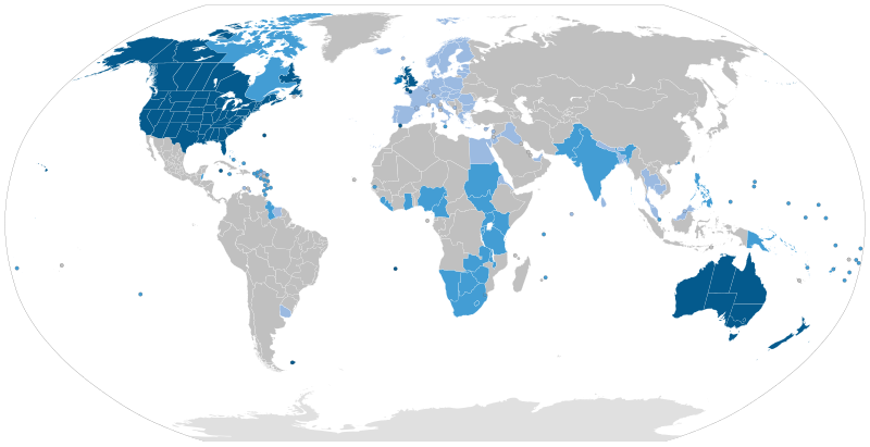
English: Majority native language
Co-official and majority native language
Official but minority native language
Secondary language: spoken as a second language by more than 20% of the population, de facto working language of government, language of instruction in education, etc. |
| تریخ | |
| سروت | Speaker figures based on Ethnologue and other sources. Blank map: File:BlankMap-World6-Subdivisions.svg |
| لکھاری | Jpthefish |
لائسنس –
میں، اس کم دے کاپیرائٹ دا مالک، اس کم نوں اس لائسنس دے مطابق چھاپدا واں:
This file is licensed under the Creative Commons Attribution-Share Alike 4.0 International license.
- تہانوں کھلھ اے:
- حصہ کرنا – کاپی، ونڈنا تے کم بھیجنا
- فیر رلانا – کم نوں فٹ کرنا
- تھلے دتیاں شرطاں نال:
- کس دے ناں – تسیں لازمی ایس کم دے بناں والے بارے دسو جنج اونے آکھیا اے یا جنج لسنس چ آکھیا گیا ہے۔
- اکو جہا شئیر کرو۔ – اگر تسیں بدلدے یا ایس کم تے بناندے تے بنن والے کم نوں اینج دے لسنس نال ای ونڈو گے۔
فائل دی تریخ
فائل نو اس ویلے دی حالت وچ ویکھن واسطے تاریخ/ویلے تے کلک کرو۔
| تریخ تے ویلہ | نکی مورت | پاسے | ورتن والا | تیپّݨی کرو | |
|---|---|---|---|---|---|
| موجودہ | ۱۴:۵۱, ۲۶ اگست ۲۰۲۳ | | ۲,۵۶۰ × ۱,۳۱۴ (۱.۳۸ میگابائٹ) | Kwamikagami | rv: you just removed light blue, which we use on other maps |
| ۰۶:۳۵, ۲۶ اگست ۲۰۲۳ |  | ۲,۵۶۰ × ۱,۳۱۴ (۱.۳۶ میگابائٹ) | Jpthefish | Reverted to version as of 01:23, 3 July 2020 (UTC) Forgive me if I am mistaken, but I have not seen sources to corroborate the light blue coloring of the EU, SE Asia, or other regions. The light blue color in my other maps was previously reserved for lanauges with cultural or secondary status - that is, a historically significant language and/or a language spoken by over 20% of the native population. I am open to changes though, as long as they are consistent across all SVG maps and reflect a... | |
| ۱۰:۴۲, ۹ اگست ۲۰۲۳ |  | ۲,۵۶۰ × ۱,۳۱۴ (۱.۳۸ میگابائٹ) | Kwamikagami | some countries marked as majority English were majority creole | |
| ۱۱:۳۳, ۱۵ جنوری ۲۰۲۳ |  | ۲,۵۶۰ × ۱,۳۱۴ (۱.۳۸ میگابائٹ) | Kwamikagami | clean up Quebec; Faroes assumed | |
| ۱۰:۵۰, ۱۵ جنوری ۲۰۲۳ |  | ۲,۵۶۰ × ۱,۳۱۴ (۱.۳۸ میگابائٹ) | Kwamikagami | 2nd language >20%, & de facto govt working language, per Ethnologue. | |
| ۰۶:۲۳, ۳ جولائی ۲۰۲۰ |  | ۲,۵۶۰ × ۱,۳۱۴ (۱.۳۶ میگابائٹ) | Jpthefish | New section | |
| ۰۳:۴۷, ۹ جون ۲۰۲۰ |  | ۲,۵۶۰ × ۱,۳۱۴ (۱.۳۶ میگابائٹ) | Jpthefish | Lighter secondary colors | |
| ۲۲:۱۷, ۲۵ مئی ۲۰۲۰ |  | ۲,۵۶۰ × ۱,۳۱۴ (۱.۳۶ میگابائٹ) | Jpthefish | edit Channel Islands | |
| ۲۳:۱۹, ۸ مئی ۲۰۲۰ |  | ۲,۵۶۰ × ۱,۳۱۴ (۱.۳۶ میگابائٹ) | Jpthefish | Add Cameroon | |
| ۰۷:۱۵, ۸ مئی ۲۰۲۰ |  | ۲,۵۶۰ × ۱,۳۱۴ (۱.۳۶ میگابائٹ) | Jpthefish | Uploaded own work with UploadWizard |
فائل دی ورتوں
تھلے دتے گئے 2 صفحے اس فائل نال جُڑدے نیں
فائل ویاپک ورتوں
ایہہ دوجے وکیاں ایس فائل نوں ورتدے نیں –
- af.wikipedia.org تے ورتوں
- ang.wikipedia.org تے ورتوں
- ar.wikipedia.org تے ورتوں
- ast.wikipedia.org تے ورتوں
- av.wikipedia.org تے ورتوں
- az.wikipedia.org تے ورتوں
- ba.wikipedia.org تے ورتوں
- be.wikipedia.org تے ورتوں
- bg.wikipedia.org تے ورتوں
- bn.wikipedia.org تے ورتوں
- br.wikipedia.org تے ورتوں
- cv.wikipedia.org تے ورتوں
- en.wikipedia.org تے ورتوں
- en.wikibooks.org تے ورتوں
- es.wikipedia.org تے ورتوں
- fa.wikipedia.org تے ورتوں
- fr.wikipedia.org تے ورتوں
- ga.wikipedia.org تے ورتوں
- guc.wikipedia.org تے ورتوں
- he.wikipedia.org تے ورتوں
- hr.wikipedia.org تے ورتوں
- hy.wikipedia.org تے ورتوں
- id.wikipedia.org تے ورتوں
- incubator.wikimedia.org تے ورتوں
- it.wikipedia.org تے ورتوں
ایس فائل دا ویکھو ہور جگت ورتن .