
فائل:EmpireFrench.png

ایس وکھالے دا ناپ: ۸۰۰ × ۴۰۷ پکسلز۔ دوجے ریزولوشنز: ۳۲۰ × ۱۶۳ پکسلز | ۶۴۰ × ۳۲۵ پکسلز | ۱,۰۲۴ × ۵۲۱ پکسلز | ۱,۲۸۰ × ۶۵۱ پکسلز | ۲,۷۵۳ × ۱,۴۰۰ پکسلز ۔
اصل فائل (۲,۷۵۳ × ۱,۴۰۰ پکسلز, فائل حجم: ۱۹۳ کلوبائٹ, MIME type: image/png)


|
This historical map image could be re-created using vector graphics as an SVG file. This has several advantages; see Commons:Media for cleanup for more information. If an SVG form of this image is available, please upload it and afterwards replace this template with
{{vector version available|new image name}}.
It is recommended to name the SVG file “EmpireFrench.svg”—then the template Vector version available (or Vva) does not need the new image name parameter. |
خلاصہ
| تفصیل |
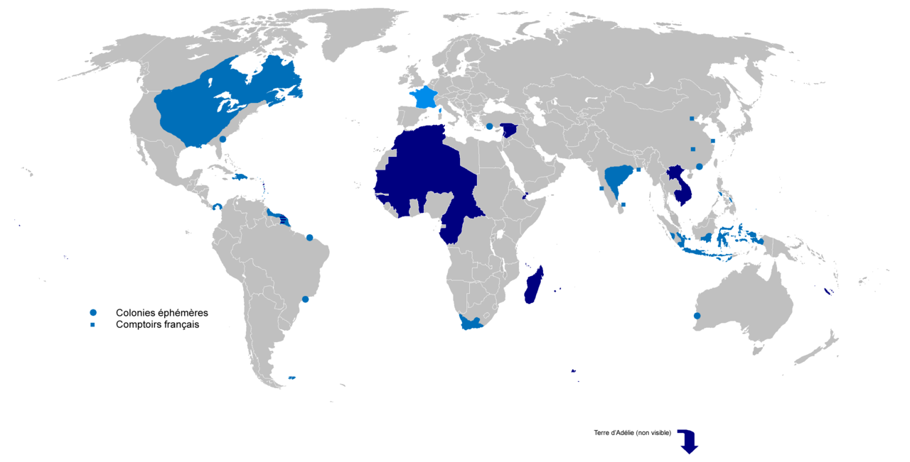
English: Colonial empire from 1542 to 1980
Dark Blue: Second colonial empire Light Blue: First colonial empire |
| تریخ | 01/06/2010 |
| سروت | آپݨا کم |
| لکھاری | Gd21091993 |
لائسنس –
| میں، اس کم دے کاپیرائٹ دا مالک، اس کم نوں لوکاں واسطے دیندا واں۔ اے سارے جگ واسطے لاگو اے۔ کج ملکاں چ قانونی طور تے اے ممکن نئیں اے؛ اگر انج ای اے ے: میں ہر کسے نوں اس کم نوں کسے وی مقصد واسطے ورتن دا بغیر کسے شرط دے حق دیندا واں، اگر اوہ قانون دے خلاف نا ہوۓ۔ |
فائل دی تریخ
فائل نو اس ویلے دی حالت وچ ویکھن واسطے تاریخ/ویلے تے کلک کرو۔
| تریخ تے ویلہ | نکی مورت | پاسے | ورتن والا | تیپّݨی کرو | |
|---|---|---|---|---|---|
| موجودہ | ۲۲:۰۲, ۴ اپریل ۲۰۲۲ | | ۲,۷۵۳ × ۱,۴۰۰ (۱۹۳ کلوبائٹ) | Oort kuipert | added territory in india and america, source : https://commons.wikimedia.org/wiki/File:New_France_(orthographic_projection).svg https://commons.wikimedia.org/wiki/File:French_possessions_in_the_Americas_(1534-1803).png https://commons.wikimedia.org/wiki/File:Evolution_empire.png |
| ۲۰:۴۱, ۳۰ مارچ ۲۰۲۲ |  | ۲,۷۵۳ × ۱,۴۰۰ (۱۹۴ کلوبائٹ) | Oort kuipert | added colonies under Napoléon I according to https://upload.wikimedia.org/wikipedia/commons/3/33/French_Empire_on_World_1812.png | |
| ۱۷:۰۱, ۸ اکتوبر ۲۰۱۷ |  | ۲,۷۵۳ × ۱,۴۰۰ (۱۱۶ کلوبائٹ) | SUM1 | Fixes: unshaded Spanish Morocco (Cape Juby), Equatorial Guinea, Nigeria, Southern Cameroons, Zanzibar, Czech border | |
| ۱۸:۴۶, ۲ مارچ ۲۰۱۶ |  | ۲,۷۵۳ × ۱,۴۰۰ (۹۹ کلوبائٹ) | Frans45 | in New Caledonia archipelago only the big island was marked, I added : îles Loayutés, île de Pins, îles Chesterfield | |
| ۲۰:۲۹, ۱ جون ۲۰۱۰ |  | ۲,۷۵۳ × ۱,۴۰۰ (۳۱۶ کلوبائٹ) | Gd21091993 | {{Information |Description={{fr|1=Carte de l'Empire Colonial Français de 1542 à 1980 }} |Source={{own}} |Author=Gd21091993 |Date=01/06/2010 |Permission= |other_versions= }} |
فائل دی ورتوں
تھلے دتے گئے 1 صفحے اس فائل نال جُڑدے نیں
فائل ویاپک ورتوں
ایہہ دوجے وکیاں ایس فائل نوں ورتدے نیں –
- ar.wikipedia.org تے ورتوں
- ast.wikipedia.org تے ورتوں
- azb.wikipedia.org تے ورتوں
- bg.wikipedia.org تے ورتوں
- br.wikipedia.org تے ورتوں
- ca.wikipedia.org تے ورتوں
- cs.wikipedia.org تے ورتوں
- el.wikipedia.org تے ورتوں
- en.wikipedia.org تے ورتوں
- Empire
- User:Dimadick
- Kingdom of France
- French colonial flags
- Analysis of Western European colonialism and colonization
- Evolution of the French Empire
- Political history of the world
- User:Jethwarp
- Timeline of European imperialism
- List of modern great powers
- User:Jethwarp/UBX/French Colonial empire
- Category:Wikipedians interested in European colonial empires
- Liberation of France
- Honor killings by region
- en.wikibooks.org تے ورتوں
- en.wikiquote.org تے ورتوں
- en.wiktionary.org تے ورتوں
- eo.wikipedia.org تے ورتوں
- es.wikipedia.org تے ورتوں
- eu.wikipedia.org تے ورتوں
- fa.wikipedia.org تے ورتوں
- fi.wikipedia.org تے ورتوں
- fr.wikipedia.org تے ورتوں
- fr.wiktionary.org تے ورتوں
- gl.wikipedia.org تے ورتوں
ایس فائل دا ویکھو ہور جگت ورتن .