
فائل:Empire of the Kökturks.png

ایس وکھالے دا ناپ: ۸۰۰ × ۴۹۹ پکسلز۔ دوجے ریزولوشنز: ۳۲۰ × ۲۰۰ پکسلز | ۶۴۰ × ۳۹۹ پکسلز | ۱,۰۲۴ × ۶۳۸ پکسلز | ۱,۲۸۰ × ۷۹۸ پکسلز | ۱,۷۴۵ × ۱,۰۸۸ پکسلز ۔
اصل فائل (۱,۷۴۵ × ۱,۰۸۸ پکسلز, فائل حجم: ۲.۵۶ میگابائٹ, MIME type: image/png)
خلاصہ
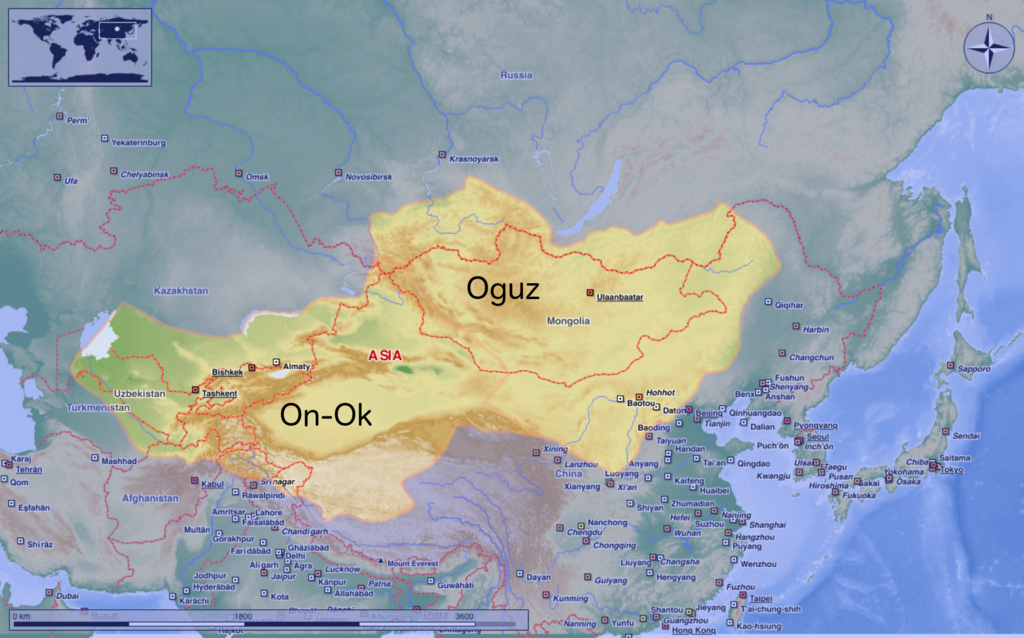
| تفصیل | This map shows the kingdom of Kökturks after the division of the kingdom in 552. The grey area shows the area of On-Ok or the western Kökturks. The white area shows the area of the eastern Kökturk. This area was still in the sixth Century a Chinese protectorate. 745 the Kökturks were part of the Uyghur empire. After 840 Kökturks and the Uyghurs were conquered by the Kyrgyz. The source of this map: "Der große Atlas Weltgeschichte", Orbis Verlag 1990, ISBN 3-572-04755-2, P. 47 & 51 |
| تریخ | |
| سروت | آپݨا کم |
| لکھاری | Hardcore-Mike |
لائسنس –
میں، اس کم دے کاپیرائٹ دا مالک، اس کم نوں اس لائسنس دے مطابق چھاپدا واں:
ایس فائل نوں کریٹو کامنز Attribution 3.0 انپورٹڈ لائسنس دتا گیا.
- تہانوں کھلھ اے:
- حصہ کرنا – کاپی، ونڈنا تے کم بھیجنا
- فیر رلانا – کم نوں فٹ کرنا
- تھلے دتیاں شرطاں نال:
- کس دے ناں – تسیں لازمی ایس کم دے بناں والے بارے دسو جنج اونے آکھیا اے یا جنج لسنس چ آکھیا گیا ہے۔
فائل دی تریخ
فائل نو اس ویلے دی حالت وچ ویکھن واسطے تاریخ/ویلے تے کلک کرو۔
| تریخ تے ویلہ | نکی مورت | پاسے | ورتن والا | تیپّݨی کرو | |
|---|---|---|---|---|---|
| موجودہ | ۱۵:۱۶, ۱۰ اگست ۲۰۲۰ | | ۱,۷۴۵ × ۱,۰۸۸ (۲.۵۶ میگابائٹ) | MicBy67 | Leichte Überarbeitung der Grenzverläufe, Änderung des westl. Teilreiches in "On-Ok" |
| ۰۵:۴۸, ۲۶ جولائی ۲۰۲۰ |  | ۱,۷۴۵ × ۱,۰۸۸ (۲.۵۶ میگابائٹ) | MicBy67 | Überarbeitung | |
| ۰۰:۵۹, ۲ نومبر ۲۰۱۲ |  | ۱,۰۵۶ × ۸۵۰ (۱.۱۷ میگابائٹ) | MicBy67 | Map fault repaired | |
| ۲۳:۱۷, ۱ نومبر ۲۰۱۲ |  | ۱,۰۵۶ × ۸۵۰ (۱.۱۷ میگابائٹ) | MicBy67 | {{Information |Description=This map shows the kingdom of Kökturks after the division of the kingdom in 552. The grey area shows the area of On-Ok or the western Kökturks. The white area shows the area of the eastern Kökturk. This area was still in t... |
فائل دی ورتوں
تھلے دتے گئے 1 صفحے اس فائل نال جُڑدے نیں
فائل ویاپک ورتوں
ایہہ دوجے وکیاں ایس فائل نوں ورتدے نیں –
- ast.wikipedia.org تے ورتوں
- cs.wikipedia.org تے ورتوں
- de.wikipedia.org تے ورتوں
- en.wikipedia.org تے ورتوں
- es.wikipedia.org تے ورتوں
- fr.wikipedia.org تے ورتوں
- mn.wikipedia.org تے ورتوں
- sl.wikipedia.org تے ورتوں
- zh.wikipedia.org تے ورتوں