فائل:Europe map 1648.PNG
Page contents not supported in other languages.
آزاد انسائیکلوپیڈیا، وکیپیڈیا توں

اصل فائل(۱,۸۹۴ × ۱,۳۶۷ پکسلز, فائل حجم: ۱۹۵ کلوبائٹ, MIME type: image/png)

ایہ فائل Wikimedia Commons توں اے تے دوجیاں ویونتاں تے وی ورتی جاسکدی اے۔ گل بات اس دے فائل گل بات صفحہ تے تھلے دتی گئی۔

This historical map image could be re-created using vector graphics as an SVG file. This has several advantages; see Commons:Media for cleanup for more information. If an SVG form of this image is available, please upload it and afterwards replace this template with {{vector version available|new image name}}.


It is recommended to name the SVG file “Europe map 1648.svg”—then the template Vector version available (or Vva) does not need the new image name parameter.

خلاصہ

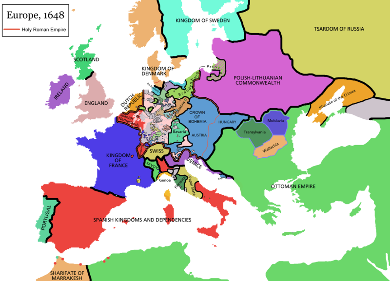
Map of Europe in 1648 (at the end of the Thirty Years War), based on free map of europe Image:BlankMap-Europe.png. Red line marks the border of the Holy Roman Empire. Information from Penguin atlas of modern history. (what year?)

Maps of the history of Europe
BCE
aC

Weichselian ice age (c. 113,000–9700) · Neolithic expansion (c. 7000–4500) · Middle Neolithic (c. 4500–4000) · Late Neolithic (c. 4000–3000) · Copper Age – Corded Ware culture (c. 2900–2350) · Copper Age – Bellbeaker culture (c. 2800–1800) · Early Bronze Age – Unetice culture (c. 2300–1600) · Late Bronze Age – Urnfield culture (c. 1300—750) · Migrations (c. 1000–100) · Hallstatt & La Tène cultures (c. 800–100) · Roman Republic (510–40) · 220 · 218 · 200 · 201–100 · 58 · 49 · 39 · 30 BCE–6 CE


CE
dC

14 · 14–37 · 60 · 60 · 69 · 80 · Migrations 100–500 · 117 · 117 · 125 · Migrations 150–774 · Economy 180 · 271 · 293–305 · 337 · 395 · c. 395 · 400 · 400 · 450 · 457–61 · 476 · 480 · Franks 481–814 · Early Slavs 500–700 · 500 · 526 · 526–600 · Christianisation to 600 · c. 550 · 650 · Pontic Steppe 650 · 665 · 800 · Vikings 800–1050 · 814 · 843–70 · 850 · 900 · 912 · 998 · 1000 · 1000 · 1054 · 1092 · First Crusade 1095–99 · 1097 · 1135 · 1142 · 1147–49 · 1190 · 1190 · 1250 · c. 1250 · 1301-1400 · 1301-1400 · 1328 · 1345 · Black Plague 1347–51 · 1360 · 1400 · Trade routes c. 1400 · 1430 · 1470 · 1490 · 1492 · 1500 · 1519 · 1550 · 1560 · Religion 1560 · Religion 1600 · Religion 1618 · 1618–48 · 1648 · 1683 · 1700 · 1701 · 1708 · 1714 · 1721 · 1725–30 · 1739–1740 · 1740 · 1748–66 · 1783–1792 · 1787 · 1787 · 1789 · 1799 · 1812 · 1812 · 1812 · 1812 · 1813 · 1815 · 1815 · 1815 · 1818 · Ottoman Empire 1830–1923 · 1848–49 · 1861 · 1867 · 1871 · 1878 · 1890 · 1905 · 1911 · 1914 · 1914 · 1919 · 1919–29 · 1923 · 1929 · 1930 · 1940 · 1941–42 · 1942–45 · Cold War 1947–91 · 1950 · 1993–2006 · 2006 to date

(this template: · view · discuss )


لائسنس –

GNU head کاپی کرن، ونڈن تے بدلن دی ایس ڈوکومنٹ ل‏ئی اجازت دتی جاندی اے ایہناں GNU Free Documentation License, Version 1.2 شرطاں نال یا مگروں کسے وی چھپے ورین Free Software Foundation توں بنا کسے انویرینٹ سیکشن دے، ناں فرنٹ کور لکھت تے ناں بیک کور لکھت دے۔ لسنس دی اک کاپی سیکشن وچ ہیگی اے جہدا ناں اے GNU Free Documentation License۔
w:en:Creative Commons
کس دے ناں اکو جہا شئیر کرو۔
ایس فائل نوں کریٹو کامنز Attribution 2.5 پولینڈ لائسنس دتا گیا.
تہانوں کھلھ اے:
  • حصہ کرنا – کاپی، ونڈنا تے کم بھیجنا
  • فیر رلانا – کم نوں فٹ کرنا
تھلے دتیاں شرطاں نال:
  • کس دے ناں – تسیں لازمی ایس کم دے بناں والے بارے دسو جنج اونے آکھیا اے یا جنج لسنس چ آکھیا گیا ہے۔
  • اکو جہا شئیر کرو۔ – اگر تسیں بدلدے یا ایس کم تے بناندے تے بنن والے کم نوں اینج دے لسنس نال ای ونڈو گے۔
اس لائسنس دا ٹیگ GFDL دے مطابق اس فائل چ پایا گیا اے licensing update۔

derivative works

Derivative works of this file:

Captions

Add a one-line explanation of what this file represents

Items portrayed in this file

چترن

copyrighted English

MIME type English

image/png

فائل دی تریخ

فائل نو اس ویلے دی حالت وچ ویکھن واسطے تاریخ/ویلے تے کلک کرو۔

(سبتوں نواں | سبھ توں پراݨا) ویکھو (زیادہ نواں ۱۰ | ) (۱۰ | ۲۰ | ۵۰ | ۱۰۰ | ۲۵۰ | ۵۰۰)
تریخ تے ویلہنکی مورتپاسےورتن والاتیپّݨی کرو
موجودہ۱۴:۴۴, ۱۴ اپریل ۲۰۲۱۱۴:۴۴, ۱۴ اپریل ۲۰۲۱ ویلے دے ورژن ساتھ انگوٹھاکار روپ۱,۸۹۴ × ۱,۳۶۷ (۱۹۵ کلوبائٹ)TenanReverted to version as of 16:09, 12 October 2017 (UTC) See discussion
۱۵:۴۷, ۹ مارچ ۲۰۲۱۱۵:۴۷, ۹ مارچ ۲۰۲۱ ویلے دے ورژن ساتھ انگوٹھاکار روپ۱,۸۹۴ × ۱,۳۶۷ (۲۱۰ کلوبائٹ)TTBCamhReverted to version as of 17:18, 20 September 2018 (UTC). I don't know why Raderich is saying this is an arbitrary change—Catalonia was under the possession of the French king in 1648, following the Catalan Revolt of 1640. This map is correct and the previous one is incorrect.
۱۷:۱۲, ۲۵ ستمبر ۲۰۱۸۱۷:۱۲, ۲۵ ستمبر ۲۰۱۸ ویلے دے ورژن ساتھ انگوٹھاکار روپ۱,۸۹۴ × ۱,۳۶۷ (۱۹۵ کلوبائٹ)RaderichReverted to version as of 21:15, 18 September 2018 (UTC) Undone arbitrary changes. Revert to correct map as uploaded by its creator Roke~commonswiki
۲۲:۱۸, ۲۰ ستمبر ۲۰۱۸۲۲:۱۸, ۲۰ ستمبر ۲۰۱۸ ویلے دے ورژن ساتھ انگوٹھاکار روپ۱,۸۹۴ × ۱,۳۶۷ (۲۱۰ کلوبائٹ)AmbroiseLThe Catalan counties were French since they proclaimed Louis XIV of France as their king. They wanted to be French in order not to obey the king of Spain anymore. Courland was a quite free vassal state of Poland. The reverted version doesn't show it. The reverted version also doesn't show the Venetian islands in the Adriatic Sea, and the Algerian towns that France occupied. Hence, I re-revert to the more precise version.
۰۲:۱۵, ۱۹ ستمبر ۲۰۱۸۰۲:۱۵, ۱۹ ستمبر ۲۰۱۸ ویلے دے ورژن ساتھ انگوٹھاکار روپ۱,۸۹۴ × ۱,۳۶۷ (۱۹۵ کلوبائٹ)RaderichReverted to version as of 16:09, 12 October 2017 (UTC)
۱۵:۴۵, ۱۹ جولائی ۲۰۱۸۱۵:۴۵, ۱۹ جولائی ۲۰۱۸ ویلے دے ورژن ساتھ انگوٹھاکار روپ۱,۸۹۴ × ۱,۳۶۷ (۲۱۰ کلوبائٹ)AmbroiseLReverted to version as of 12:06, 20 January 2017 (UTC) — reverted to the version with fixed names, my mistake
۱۵:۳۷, ۱۹ جولائی ۲۰۱۸۱۵:۳۷, ۱۹ جولائی ۲۰۱۸ ویلے دے ورژن ساتھ انگوٹھاکار روپ۱,۸۹۴ × ۱,۳۶۷ (۱۵۰ کلوبائٹ)AmbroiseLReverted to version as of 10:33, 24 September 2016 (UTC)
۲۱:۰۹, ۱۲ اکتوبر ۲۰۱۷۲۱:۰۹, ۱۲ اکتوبر ۲۰۱۷ ویلے دے ورژن ساتھ انگوٹھاکار روپ۱,۸۹۴ × ۱,۳۶۷ (۱۹۵ کلوبائٹ)Reverted to version as of 12:42, 9 September 2016 (UTC) why is Catalonia French? Not shown as such on File:Europe_1648_westphal_1884.jpg
۱۷:۰۶, ۲۰ جنوری ۲۰۱۷۱۷:۰۶, ۲۰ جنوری ۲۰۱۷ ویلے دے ورژن ساتھ انگوٹھاکار روپ۱,۸۹۴ × ۱,۳۶۷ (۲۱۰ کلوبائٹ)FakirbakirNames of Austria, Bohemia and Hungary are fixed.
۱۵:۳۳, ۲۴ ستمبر ۲۰۱۶۱۵:۳۳, ۲۴ ستمبر ۲۰۱۶ ویلے دے ورژن ساتھ انگوٹھاکار روپ۱,۸۹۴ × ۱,۳۶۷ (۱۵۰ کلوبائٹ)AmbroiseLAdjunction of polish-lithuanian vassal state of Courland
(سبتوں نواں | سبھ توں پراݨا) ویکھو (زیادہ نواں ۱۰ | ) (۱۰ | ۲۰ | ۵۰ | ۱۰۰ | ۲۵۰ | ۵۰۰)

فائل ویاپک ورتوں

ایہہ دوجے وکیاں ایس فائل نوں ورتدے نیں –

ایس فائل دا ویکھو ہور جگت ورتن .

میٹا ڈیٹا