
فائل:French Mandate for Syria and the Lebanon map en.svg

Size of this PNG preview of this SVG file: ۷۲۵ × ۵۹۹ پکسلز. دوجے ریزولوشنز: ۲۹۰ × ۲۴۰ پکسلز | ۵۸۱ × ۴۸۰ پکسلز | ۹۲۹ × ۷۶۸ پکسلز | ۱,۲۳۹ × ۱,۰۲۴ پکسلز | ۲,۴۷۸ × ۲,۰۴۸ پکسلز | ۹۲۲ × ۷۶۲ پکسلز ۔
اصل فائل (ایس وی جی فائل، پکسل:۹۲۲ × ۷۶۲، فائل سائز: ۲۴۵ کلوبائٹ)
خلاصہ
| تفصیل |
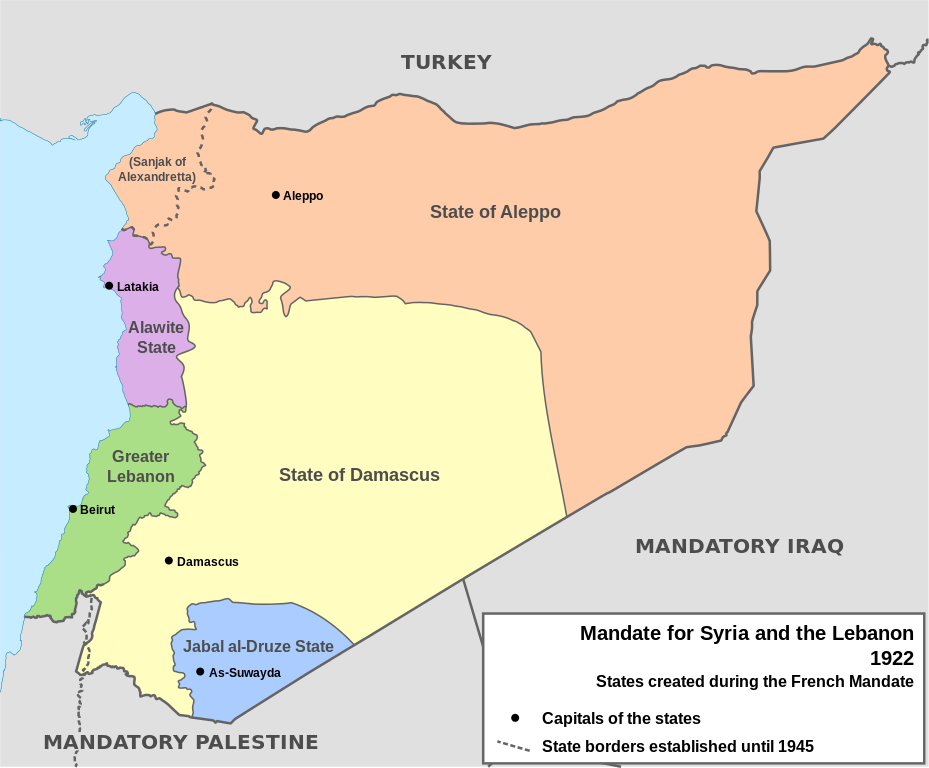
English: Map of French Mandate for Syria and the Lebanon and the states created in 1922, in English. Sources:
|
| تریخ | |
| سروت | آپݨا کم, based on File:Syria, administrative divisions - de - colored.svg |
| لکھاری | Don-kun, TUBS, NordNordWest |
| دوجے ورژن |
[]
|


لائسنس –
میں، اس کم دے کاپیرائٹ دا مالک، اس کم نوں اس لائسنس دے مطابق چھاپدا واں:

|
کاپی کرن، ونڈن تے بدلن دی ایس ڈوکومنٹ لئی اجازت دتی جاندی اے ایہناں GNU Free Documentation License, Version 1.2 شرطاں نال یا مگروں کسے وی چھپے ورین Free Software Foundation توں بنا کسے انویرینٹ سیکشن دے، ناں فرنٹ کور لکھت تے ناں بیک کور لکھت دے۔ لسنس دی اک کاپی سیکشن وچ ہیگی اے جہدا ناں اے GNU Free Documentation License۔ |
ایس فائل نوں کریٹو کامنز Attribution 3.0 انپورٹڈ لائسنس دتا گیا.
- تہانوں کھلھ اے:
- حصہ کرنا – کاپی، ونڈنا تے کم بھیجنا
- فیر رلانا – کم نوں فٹ کرنا
- تھلے دتیاں شرطاں نال:
- کس دے ناں – تسیں لازمی ایس کم دے بناں والے بارے دسو جنج اونے آکھیا اے یا جنج لسنس چ آکھیا گیا ہے۔
تسیں اپنی مرضی دا لائسنس چݨ سکدے اوہ۔
فائل دی تریخ
فائل نو اس ویلے دی حالت وچ ویکھن واسطے تاریخ/ویلے تے کلک کرو۔
| تریخ تے ویلہ | نکی مورت | پاسے | ورتن والا | تیپّݨی کرو | |
|---|---|---|---|---|---|
| موجودہ | ۲۱:۰۵, ۴ فروری ۲۰۱۳ | | ۹۲۲ × ۷۶۲ (۲۴۵ کلوبائٹ) | AnonMoos | Change "Libanon" to "Lebanon" |
| ۲۰:۳۳, ۴ فروری ۲۰۱۳ |  | ۹۲۲ × ۷۶۲ (۲۵۰ کلوبائٹ) | Don-kun | fix border to palestine, source: http://en.wikisource.org/wiki/Franco-British_Convention_on_Certain_Points_Connected_with_the_Mandates_for_Syria_and_the_Lebanon,_Palestine_and_Mesopotamia | |
| ۲۳:۴۳, ۳۰ جنوری ۲۰۱۳ |  | ۹۲۲ × ۷۶۲ (۲۴۸ کلوبائٹ) | Don-kun | minus ahistorical lakes (and so all waterbodies) | |
| ۰۲:۴۴, ۲۷ جنوری ۲۰۱۳ |  | ۹۲۲ × ۷۶۲ (۲۸۲ کلوبائٹ) | Don-kun | {{Information |Description ={{en|1=Map of French Mandate for Syria and the Lebanon and the states created in 1922, in English.}} |Source ={{own}}, based on File:Syria, administrative divisions - de - colored.svg |Author =[[User:... |
فائل دی ورتوں
تھلے دتے گئے 6 صفحے اس فائل نال جُڑدے نیں
فائل ویاپک ورتوں
ایہہ دوجے وکیاں ایس فائل نوں ورتدے نیں –
- af.wikipedia.org تے ورتوں
- ar.wikipedia.org تے ورتوں
- ast.wikipedia.org تے ورتوں
- azb.wikipedia.org تے ورتوں
- az.wikipedia.org تے ورتوں
- be.wikipedia.org تے ورتوں
- bg.wikipedia.org تے ورتوں
- bn.wikipedia.org تے ورتوں
- ca.wikipedia.org تے ورتوں
- cs.wikipedia.org تے ورتوں
- de.wikipedia.org تے ورتوں
- el.wikipedia.org تے ورتوں
- en.wikipedia.org تے ورتوں
ایس فائل دا ویکھو ہور جگت ورتن .