
فائل:Greater London boroughs 2009 map.svg

اصل فائل (ایس وی جی فائل، پکسل:۱,۴۲۵ × ۱,۱۴۰، فائل سائز: ۷۶۱ کلوبائٹ)
خلاصہ
| تفصیل |
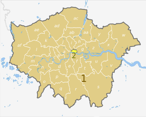
English: Map of Greater London, UK with districts shown, in the same style as other maps of English regions. The county colours are the same as those in File:English metropolitan and non-metropolitan counties 2009.svg.
Equirectangular map projection on WGS 84 datum, with N/S stretched 160%. Geographic limits:
|
| تریخ | (UTC) |
| سروت |
This file was derived from: Greater London UK district map (blank).svg: |
| لکھاری |
|
.svg)
| Map | Ceremonial county | London boroughs |
|---|---|---|
 |
1. Greater London |
a) City of Westminster, b) Kensington and Chelsea, c) Hammersmith and Fulham, d) Wandsworth, e) Lambeth, f) Southwark, g) Tower Hamlets, h) Hackney, i) Islington, j) Camden, k) Brent, l) Ealing, m) Hounslow, n) Richmond, o) Kingston upon Thames, p) Merton, q) Sutton, r) Croydon, s) Bromley, t) Lewisham, u) Greenwich, v) Bexley, w) Havering, x) Barking and Dagenham, y) Redbridge, z) Newham, aa) Waltham Forest, ab) Haringey, ac) Enfield, ad) Barnet, ae) Harrow, af) Hillingdon |
| 2. City of London | ||
| This is a retouched picture, which means that it has been digitally altered from its original version. Modifications: recoloured and labelled in same style as other English regional maps. The original can be viewed here: Greater London UK district map (blank).svg:
|
لائسنس –
- تہانوں کھلھ اے:
- حصہ کرنا – کاپی، ونڈنا تے کم بھیجنا
- فیر رلانا – کم نوں فٹ کرنا
- تھلے دتیاں شرطاں نال:
- کس دے ناں – تسیں لازمی ایس کم دے بناں والے بارے دسو جنج اونے آکھیا اے یا جنج لسنس چ آکھیا گیا ہے۔
- اکو جہا شئیر کرو۔ – اگر تسیں بدلدے یا ایس کم تے بناندے تے بنن والے کم نوں اینج دے لسنس نال ای ونڈو گے۔
پہلا اپلوڈ دا ریکارڈ
This image is a derivative work of the following images:
- File:Greater_London_UK_district_map_(blank).svg licensed with Cc-by-sa-3.0
- 2010-08-22T08:09:33Z Nilfanion 1425x1140 (1104179 Bytes) +inset, water colour tweak
- 2010-07-16T23:35:33Z Nilfanion 1425x1140 (738807 Bytes) {{Information |Description=Map of [[w:Greater London|Greater London]], UK with districts shown. Equirectangular map projection on WGS 84 datum, with N/S stretched 160% Geographic limits: *West: 0.57W *East: 0.37E *North: 51
Uploaded with derivativeFX
فائل دی تریخ
فائل نو اس ویلے دی حالت وچ ویکھن واسطے تاریخ/ویلے تے کلک کرو۔
| تریخ تے ویلہ | نکی مورت | پاسے | ورتن والا | تیپّݨی کرو | |
|---|---|---|---|---|---|
| موجودہ | ۰۳:۰۵, ۳ مئی ۲۰۱۲ | | ۱,۴۲۵ × ۱,۱۴۰ (۷۶۱ کلوبائٹ) | Dr Greg | == {{int:filedesc}} == {{Information |Description={{en|Map of Greater London, UK with districts shown, in the same style as other maps of English regions. The county colours are the same as those in [[:File:English metropolitan and... |
فائل دی ورتوں
تھلے دتے گئے 1 صفحے اس فائل نال جُڑدے نیں
فائل ویاپک ورتوں
ایہہ دوجے وکیاں ایس فائل نوں ورتدے نیں –
- ar.wikipedia.org تے ورتوں
- de.wikipedia.org تے ورتوں
- en.wikipedia.org تے ورتوں
- fr.wikipedia.org تے ورتوں
- th.wikipedia.org تے ورتوں
- ur.wikipedia.org تے ورتوں
- zh-yue.wikipedia.org تے ورتوں