
فائل:Greater London in England (wo City of London) (zoom).svg

Size of this PNG preview of this SVG file: ۴۹۴ × ۶۰۰ پکسلز. دوجے ریزولوشنز: ۱۹۸ × ۲۴۰ پکسلز | ۳۹۵ × ۴۸۰ پکسلز | ۶۳۲ × ۷۶۸ پکسلز | ۸۴۳ × ۱,۰۲۴ پکسلز | ۱,۶۸۶ × ۲,۰۴۸ پکسلز | ۸۱۶ × ۹۹۱ پکسلز ۔
اصل فائل (ایس وی جی فائل، پکسل:۸۱۶ × ۹۹۱، فائل سائز: ۱.۳۲ میگابائٹ)
خلاصہ
| تفصیل |
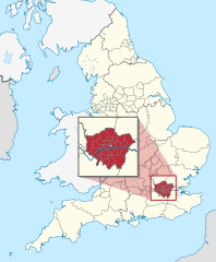
Deutsch: Lage der zeremoniellen Grafschaft XY (siehe Dateiname) inmitten der nicht-zeremoniellen Verwaltungsgliederung in England. (Rot markiert ist also das Gebiet einer zeremoniellen Grafschaft. Eingezeichnet sind also innerhalb Englands nur die Grenze der Regionen, der ländlichen Grafschaften, der städtischen Bezirke als Teilgebiete der städtischen Grafschaften, der Bezirke Londons, und der Gebiete der einstufigen Verwaltungen.)
English: Location of ceremonial county xy (see filename) within non-ceremonial administrative divisions in England. (Hence, within England, the maps shows only borders of regions, of non-metropolitan counties, of metropolitan boroughs (i.e. subdivisions of metropolitan counties), of the areas of unitary authorities and of the London boroughs.) |
||||
| تریخ | |||||
| سروت |
آپݨا کم This W3C-unspecified vector image was created with Adobe Illustrator. This SVG file was uploaded with Commonist. This vector image includes elements that have been taken or adapted from this file: This vector image includes elements that have been taken or adapted from this file: |
||||
| لکھاری |
TUBS |
||||
| دوجے ورژن |
|
||||
.svg)
.svg)
.svg)
.svg)
.svg)
.svg)
.svg)

-en.svg)

.svg)
.svg)
.svg)

_(US48).svg)
_(small_islands_magnified)_(-mini_map_-rivers).svg)
.svg)
_(extra_close)_(US48).svg)
.svg)
_(zoom).svg)

.svg)


_(UNMIK).svg)
.svg)
_(disputed_hatched).svg)
_(claimed_and_disputed_hatched).svg)
.svg)
.svg)
_(%2Ball_claims_hatched).svg)

.svg)
_(shade).svg)
_(shade)_(special_marker).svg)
_(-mini_map).svg)
_(-mini_map).svg)
_(-mini_map).svg)


.svg)

.svg)
_(zoom).svg)
لائسنس –
میں، اس کم دے کاپیرائٹ دا مالک، اس کم نوں اس لائسنس دے مطابق چھاپدا واں:
ایس فائل نوں کریٹو کامنز Attribution 2.5 پولینڈ لائسنس دتا گیا.
- تہانوں کھلھ اے:
- حصہ کرنا – کاپی، ونڈنا تے کم بھیجنا
- فیر رلانا – کم نوں فٹ کرنا
- تھلے دتیاں شرطاں نال:
- کس دے ناں – تسیں لازمی ایس کم دے بناں والے بارے دسو جنج اونے آکھیا اے یا جنج لسنس چ آکھیا گیا ہے۔
- اکو جہا شئیر کرو۔ – اگر تسیں بدلدے یا ایس کم تے بناندے تے بنن والے کم نوں اینج دے لسنس نال ای ونڈو گے۔

|
I'd greatly appreciate, that you attribute this media file to Wikimedia Commons, if used outside Wikipedia or Commons. For use in publications such as books, newspapers, blogs, websites, please insert here the following line:
|
_(zoom).svg&action=edit&redlink=1)
فائل دی تریخ
فائل نو اس ویلے دی حالت وچ ویکھن واسطے تاریخ/ویلے تے کلک کرو۔
| تریخ تے ویلہ | نکی مورت | پاسے | ورتن والا | تیپّݨی کرو | |
|---|---|---|---|---|---|
| موجودہ | ۰۲:۴۸, ۲۹ نومبر ۲۰۱۱ | | ۸۱۶ × ۹۹۱ (۱.۳۲ میگابائٹ) | TUBS |
فائل دی ورتوں
تھلے دتے گئے 1 صفحے اس فائل نال جُڑدے نیں
فائل ویاپک ورتوں
ایہہ دوجے وکیاں ایس فائل نوں ورتدے نیں –
- az.wikipedia.org تے ورتوں
- en.wikipedia.org تے ورتوں
- fa.wikipedia.org تے ورتوں
- he.wikipedia.org تے ورتوں
- ja.wikipedia.org تے ورتوں
- ko.wikipedia.org تے ورتوں
- ms.wikipedia.org تے ورتوں
- no.wikipedia.org تے ورتوں
- qu.wikipedia.org تے ورتوں
- th.wikipedia.org تے ورتوں
- tum.wikipedia.org تے ورتوں
- uk.wikipedia.org تے ورتوں
- ur.wikipedia.org تے ورتوں
_(zoom).svg)