
فائل:Historicalcapitalsofchina ancient.png
ایس وکھالے دا ناپ: ۵۶۳ × ۵۹۹ پکسلز۔ دوجے ریزولوشنز: ۲۲۵ × ۲۴۰ پکسلز | ۴۵۱ × ۴۸۰ پکسلز | ۷۲۱ × ۷۶۸ پکسلز | ۱,۰۸۰ × ۱,۱۵۰ پکسلز ۔
اصل فائل (۱,۰۸۰ × ۱,۱۵۰ پکسلز, فائل حجم: ۱۷۶ کلوبائٹ, MIME type: image/png)
This image was copied from wikipedia:en. The original description was:
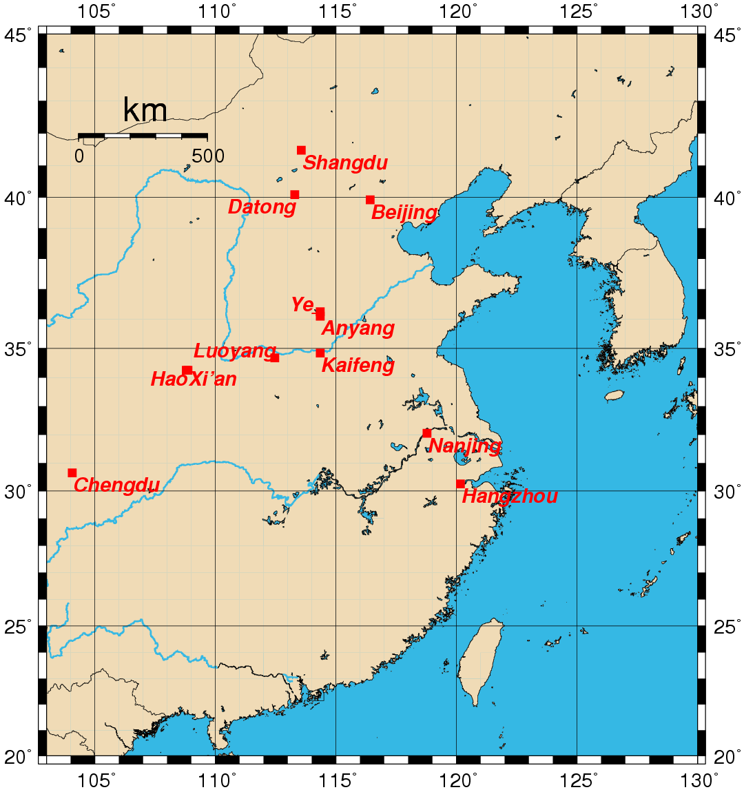
Map showing the location of the historical capitals of China in use prior to the 20th century. Map created by Rolf Müller using the Generic Mapping Tools (GMT).
Geographical coordinates (latitude, longitude) used:
- Anyang 36.1000 114.3500
- Beijing 39.9166 116.4166
- Chengdu 30.6500 104.0666
- Datong 40.0833 113.3000
- Hangzhou 30.2500 120.1666
- Hao 34.2500 108.8000
- Kaifeng 34.8500 114.3500
- Luoyang 34.6833 112.4666
- Nanjing 32.0500 118.7833
- Shangdu 41.4833 113.5666
- Xi'an 34.2500 108.8666
- Ye 36.2500 114.3500
External link

|
کاپی کرن، ونڈن تے بدلن دی ایس ڈوکومنٹ لئی اجازت دتی جاندی اے ایہناں GNU Free Documentation License, Version 1.2 شرطاں نال یا مگروں کسے وی چھپے ورین Free Software Foundation توں بنا کسے انویرینٹ سیکشن دے، ناں فرنٹ کور لکھت تے ناں بیک کور لکھت دے۔ لسنس دی اک کاپی سیکشن وچ ہیگی اے جہدا ناں اے GNU Free Documentation License۔ |
| ایس فائل نوں کریٹو کامنز Attribution 2.5 پولینڈ لائسنس دتا گیا. | ||
| ||
| اس لائسنس دا ٹیگ GFDL دے مطابق اس فائل چ پایا گیا اے licensing update۔ |
| date/time | username | edit summary |
|---|---|---|
| 00:02, 25 August 2005 | Rolfmueller | (19th -> 20th century division) |
| 00:14, 24 August 2005 | Rolfmueller | (add links & coordinates) |
| 00:14, 24 August 2005 | Rolfmueller | (add links & coordinates) |
| 11:44, 23 August 2005 | Rolfmueller | (image information added) |
| 11:36, 23 August 2005 | Rolfmueller | (uploaded {{GFDL}}) |
فائل دی تریخ
فائل نو اس ویلے دی حالت وچ ویکھن واسطے تاریخ/ویلے تے کلک کرو۔
| تریخ تے ویلہ | نکی مورت | پاسے | ورتن والا | تیپّݨی کرو | |
|---|---|---|---|---|---|
| موجودہ | ۱۲:۵۳, ۲۳ اکتوبر ۲۰۰۵ | | ۱,۰۸۰ × ۱,۱۵۰ (۱۷۶ کلوبائٹ) | ChongDae | This image was copied from wikipedia:en. The original description was: Map showing the location of the historical capitals of China in use prior to the 20th century. Map created by Rolf Müller using the Generic Ma |
فائل دی ورتوں
تھلے دتے گئے 1 صفحے اس فائل نال جُڑدے نیں
فائل ویاپک ورتوں
ایہہ دوجے وکیاں ایس فائل نوں ورتدے نیں –
- cs.wikipedia.org تے ورتوں
- de.wikipedia.org تے ورتوں
- en.wikipedia.org تے ورتوں
- es.wikipedia.org تے ورتوں
- fr.wikipedia.org تے ورتوں
- hy.wikipedia.org تے ورتوں
- id.wikipedia.org تے ورتوں
- it.wikipedia.org تے ورتوں
- ko.wikipedia.org تے ورتوں
- ru.wikipedia.org تے ورتوں
- uk.wikipedia.org تے ورتوں
- ur.wikipedia.org تے ورتوں