
فائل:Ionian Revolt Campaign Map.png
ایس وکھالے دا ناپ: ۴۹۳ × ۵۹۹ پکسلز۔ دوجے ریزولوشنز: ۱۹۷ × ۲۴۰ پکسلز | ۳۹۵ × ۴۸۰ پکسلز | ۶۳۲ × ۷۶۸ پکسلز | ۸۴۲ × ۱,۰۲۴ پکسلز | ۱,۶۴۵ × ۲,۰۰۰ پکسلز ۔
اصل فائل (۱,۶۴۵ × ۲,۰۰۰ پکسلز, فائل حجم: ۴.۲۴ میگابائٹ, MIME type: image/png)
| تفصیل |
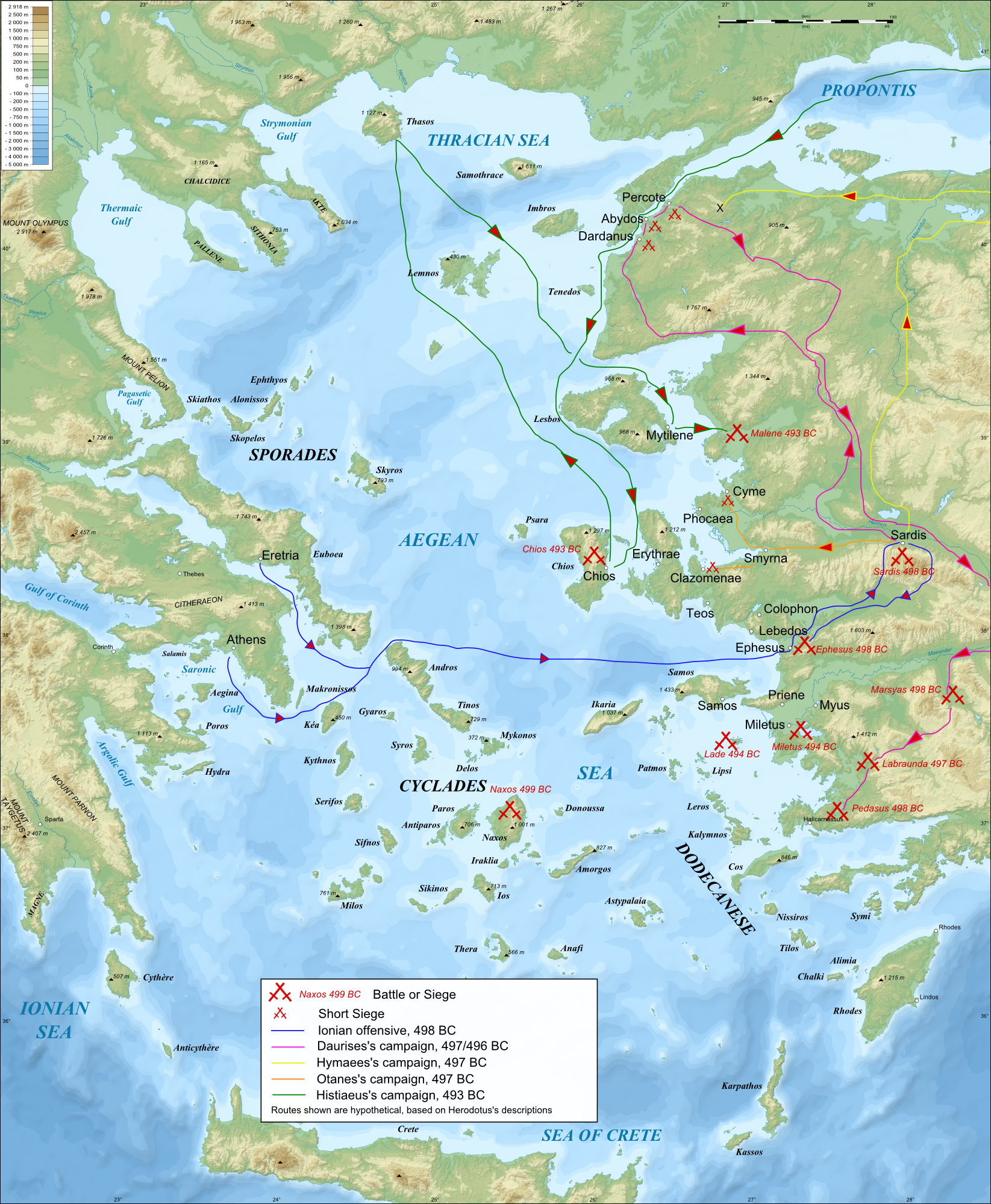
English: Bathymetric/Topographical map of the Aegean area in c.500 BC, showing major events of the Ionian Revolt.
|
| تریخ | (UTC) |
| سروت | |
| لکھاری |
|
| دوجے ورژن |
|


| This is a retouched picture, which means that it has been digitally altered from its original version. Modifications: Modified map to more ancient names, and constructed campaign map of Ionina revolt. The original can be viewed here: Aegean Sea map bathymetry-fr.svg:
|
میں، اس کم دے کاپیرائٹ دا مالک، اس کم نوں اس لائسنس دے مطابق چھاپدا واں:
ایہ فائل ایس لسنس Creative Commons Attribution-Share Alike 3.0 Unported, 2.5 Generic, 2.0 Generic and 1.0 Generic نال چلدی اے۔
- تہانوں کھلھ اے:
- حصہ کرنا – کاپی، ونڈنا تے کم بھیجنا
- فیر رلانا – کم نوں فٹ کرنا
- تھلے دتیاں شرطاں نال:
- کس دے ناں – تسیں لازمی ایس کم دے بناں والے بارے دسو جنج اونے آکھیا اے یا جنج لسنس چ آکھیا گیا ہے۔
- اکو جہا شئیر کرو۔ – اگر تسیں بدلدے یا ایس کم تے بناندے تے بنن والے کم نوں اینج دے لسنس نال ای ونڈو گے۔

|
کاپی کرن، ونڈن تے بدلن دی ایس ڈوکومنٹ لئی اجازت دتی جاندی اے ایہناں GNU Free Documentation License, Version 1.2 شرطاں نال یا مگروں کسے وی چھپے ورین Free Software Foundation توں بنا کسے انویرینٹ سیکشن دے، ناں فرنٹ کور لکھت تے ناں بیک کور لکھت دے۔ لسنس دی اک کاپی سیکشن وچ ہیگی اے جہدا ناں اے GNU Free Documentation License۔ |
تسیں اپنی مرضی دا لائسنس چݨ سکدے اوہ۔
پہلا اپلوڈ دا ریکارڈ
This image is a derivative work of the following images:
- File:Aegean_Sea_map_bathymetry-fr.svg licensed with Cc-by-sa-3.0,2.5,2.0,1.0, GFDL
- 2009-02-08T00:35:16Z Sting 3750x4560 (3597775 Bytes) Correcting display bug - new try - step #2
- 2009-02-08T00:29:02Z Sting 3750x4560 (410188 Bytes) Correcting display bug - new try - step #1
- 2009-02-08T00:14:50Z Sting 3750x4560 (3740562 Bytes) Correcting display bug
- 2009-02-06T07:54:54Z Future Perfect at Sunrise 3750x4560 (3742390 Bytes) null edit, re-uploading to try to force display to be reset, background image wasn't displaying
- 2009-02-06T07:52:12Z Future Perfect at Sunrise 3750x4560 (3742390 Bytes) null edit, re-uploading to try to force display to be reset, background image wasn't displaying
- 2008-09-28T21:11:49Z Sting 3750x4560 (3742390 Bytes) Completely new background using ETOPO1 data ; new standard colors ; some additional labels
- 2007-11-27T13:16:40Z Sting 3750x4560 (4078448 Bytes) Elevation on Chios
- 2007-11-26T23:25:43Z Sting 3750x4560 (4078446 Bytes) correction
- 2007-11-21T22:42:53Z Sting 3750x4560 (4079234 Bytes) Additional sea names
- 2007-11-21T20:21:26Z Sting 3750x4560 (4078039 Bytes) Additional key
- 2007-11-21T19:10:35Z Sting 3750x4560 (4072878 Bytes) {{Information |Description=Bathymetric map in French of the [[:Category:Aegean Sea|Aegean Sea]], Mediterranean Sea |Source=Own work ;Raster relief background map : [http://www2.jpl.nasa.gov/srtm NASA Shuttle Radar Topography
Uploaded with derivativeFX
فائل دی تریخ
فائل نو اس ویلے دی حالت وچ ویکھن واسطے تاریخ/ویلے تے کلک کرو۔
| تریخ تے ویلہ | نکی مورت | پاسے | ورتن والا | تیپّݨی کرو | |
|---|---|---|---|---|---|
| موجودہ | ۱۱:۳۵, ۲۳ اپریل ۲۰۰۹ | | ۱,۶۴۵ × ۲,۰۰۰ (۴.۲۴ میگابائٹ) | MinisterForBadTimes | {{Information |Description=40px '''Note:''' this SVG map has a display bug on this page (size too large?) but works fine in Inkscape. Consider using the raster version in the art |
فائل دی ورتوں
تھلے دتے گئے 1 صفحے اس فائل نال جُڑدے نیں
فائل ویاپک ورتوں
ایہہ دوجے وکیاں ایس فائل نوں ورتدے نیں –
- azb.wikipedia.org تے ورتوں
- ca.wikipedia.org تے ورتوں
- el.wikipedia.org تے ورتوں
- en.wikipedia.org تے ورتوں
- eu.wikipedia.org تے ورتوں
- fa.wikipedia.org تے ورتوں
- fr.wikipedia.org تے ورتوں
- hr.wikipedia.org تے ورتوں
- hy.wikipedia.org تے ورتوں
- id.wikipedia.org تے ورتوں
- it.wikipedia.org تے ورتوں
- it.wikiversity.org تے ورتوں
- ko.wikipedia.org تے ورتوں
- pl.wikipedia.org تے ورتوں
- pt.wikipedia.org تے ورتوں
- ru.wikipedia.org تے ورتوں
- sh.wikipedia.org تے ورتوں
- ta.wikipedia.org تے ورتوں
- tr.wikipedia.org تے ورتوں
- uk.wikipedia.org تے ورتوں
- ur.wikipedia.org تے ورتوں
- zh.wikipedia.org تے ورتوں