
فائل:Israel-2013-Aerial 21-Masada.jpg

ایس وکھالے دا ناپ: ۴۵۰ × ۵۹۹ پکسلز۔ دوجے ریزولوشنز: ۱۸۰ × ۲۴۰ پکسلز | ۳۶۰ × ۴۸۰ پکسلز | ۵۷۷ × ۷۶۸ پکسلز | ۷۶۹ × ۱,۰۲۴ پکسلز | ۱,۵۳۸ × ۲,۰۴۸ پکسلز | ۳,۷۵۵ × ۵,۰۰۰ پکسلز ۔
اصل فائل (۳,۷۵۵ × ۵,۰۰۰ پکسلز, فائل حجم: ۱۶.۹۵ میگابائٹ, MIME type: image/jpeg)
|
This image was selected as picture of the day on Wikimedia Commons for 10 February 2021. It was captioned as follows: Other languages:
Bân-lâm-gú: Iû-tāi khòng-iá (Hi-pek-lâi-gí: מִדְבַּר יְהוּדָה, A-la-pek-gí: صحراء يهودا) tiong ê Masada (Hi-pek-lâi-gí: מצדה) ê khong-tiong hip-siòng-phìnn, lī-bô-guā-hn̄g ê sóo-tsāi sī Sí-hái. Čeština: Letecký pohled na starověkou pevnost Masada v Judské poušti na východě Izraele a Mrtvým mořem na obzoru. Français : Les fortifications de Massada dans le désert de Judée (Israël), avec la mer Morte visible dans le fond. |
خلاصہ
| تفصیل |
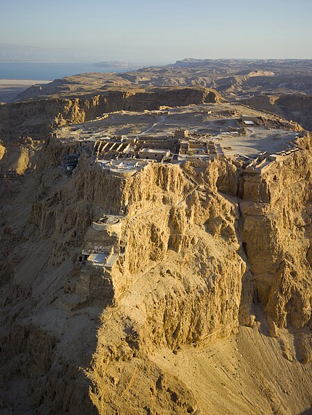
English: Aerial view of Masada (Hebrew מצדה), in the Judaean Desert (Hebrew: מִדְבַּר יְהוּדָה, Arabic: صحراء يهودا), with the Dead Sea in the distance.
Čeština: Letecký pohled na starověkou pevnost Masada v Judské poušti na východě Izraele a Mrtvým mořem na obzoru.
Bân-lâm-gú:Iû-tāi khòng-iá (Hi-pek-lâi-gí: מִדְבַּר יְהוּדָה, A-la-pek-gí: صحراء يهودا) tiong ê Masada (Hi-pek-lâi-gí: מצדה) ê khong-tiong hip-siòng-phìnn, lī-bô-guā-hn̄g ê sóo-tsāi sī Sí-hái. Français : Les fortifications de Massada dans le désert de Judée (Israël), avec la mer Morte visible dans le fond.
|
| تریخ | Taken on ۲۸ مارچ ۲۰۱۳, ۱۷:۴۹ |
| سروت | آپݨا کم |
| لکھاری | Godot13 |
| دوجے ورژن | |
| کس دے ناں (required by the license) | Andrew Shiva / Wikipedia / |

| Camera location | | View this and other nearby images on: OpenStreetMap |
|---|
لائسنس –
میں، اس کم دے کاپیرائٹ دا مالک، اس کم نوں اس لائسنس دے مطابق چھاپدا واں:
This file is licensed under the Creative Commons Attribution-Share Alike 4.0 International license.
- تہانوں کھلھ اے:
- حصہ کرنا – کاپی، ونڈنا تے کم بھیجنا
- فیر رلانا – کم نوں فٹ کرنا
- تھلے دتیاں شرطاں نال:
- کس دے ناں – تسیں لازمی ایس کم دے بناں والے بارے دسو جنج اونے آکھیا اے یا جنج لسنس چ آکھیا گیا ہے۔
- اکو جہا شئیر کرو۔ – اگر تسیں بدلدے یا ایس کم تے بناندے تے بنن والے کم نوں اینج دے لسنس نال ای ونڈو گے۔

|
ایس فائل دے کاپی حق رکھن والا Andrew Shiva ہر اک نوں اجازت دیندا اے جے اوہ اینوں ورتے کسے وی کم لئ پر پر کاپی حق رکھن والے دا ناں لازمی دسے۔ |
کس دے ناں:
Use or reproduction of this image outside of Wikipedia must give the original photographer (Andrew Shiva) credit. Although not required, it would be appreciated if a message was left here indicating where this image was being used.
|
فائل دی تریخ
فائل نو اس ویلے دی حالت وچ ویکھن واسطے تاریخ/ویلے تے کلک کرو۔
| تریخ تے ویلہ | نکی مورت | پاسے | ورتن والا | تیپّݨی کرو | |
|---|---|---|---|---|---|
| موجودہ | ۰۱:۵۴, ۲۰ اپریل ۲۰۱۳ | | ۳,۷۵۵ × ۵,۰۰۰ (۱۶.۹۵ میگابائٹ) | Godot13 | User created page with UploadWizard |
فائل دی ورتوں
تھلے دتے گئے 1 صفحے اس فائل نال جُڑدے نیں
فائل ویاپک ورتوں
ایہہ دوجے وکیاں ایس فائل نوں ورتدے نیں –
- ar.wikipedia.org تے ورتوں
- arz.wikipedia.org تے ورتوں
- av.wikipedia.org تے ورتوں
- az.wikipedia.org تے ورتوں
- be-tarask.wikipedia.org تے ورتوں
- be.wikipedia.org تے ورتوں
- bg.wikipedia.org تے ورتوں
- bn.wikipedia.org تے ورتوں
- bxr.wikipedia.org تے ورتوں
- ca.wikipedia.org تے ورتوں
- crh.wikipedia.org تے ورتوں
- cs.wikipedia.org تے ورتوں
- cv.wikipedia.org تے ورتوں
- cy.wikipedia.org تے ورتوں
- da.wikipedia.org تے ورتوں
- de.wikipedia.org تے ورتوں
- de.wikivoyage.org تے ورتوں
- en.wikipedia.org تے ورتوں
- Masada
- Talk:Masada
- Siege of Masada
- Portal:Israel
- Portal:History/Featured picture
- Wikipedia:WikiProject Israel
- Wikipedia:Featured pictures/Places/Architecture
- Israel
- User:Ynhockey/IsraelFPs
- Portal:Asia/Featured picture
- Wikipedia:WikiProject Israel/Recognized content
- Portal:Israel/Selected picture
- Portal:Israel/Selected picture/3
- Wikipedia:Featured pictures thumbs/34
- Wikipedia:Featured picture candidates/Aerial view of Masada
- Wikipedia:Featured picture candidates/May-2013
- Wikipedia:Wikipedia Signpost/2013-05-20/Featured content
- User talk:Godot13/Archive 1
- User:Godot13/sandbox/Universal Triple Crown
- User talk:Godot13/promotion archive1
- User talk:Godot13/Archive 2
- Wikipedia:Picture of the day/December 2014
ایس فائل دا ویکھو ہور جگت ورتن .