
فائل:Kırşehir districts.png
ایس وکھالے دا ناپ: ۷۳۸ × ۵۹۹ پکسلز۔ دوجے ریزولوشنز: ۲۹۶ × ۲۴۰ پکسلز | ۵۹۱ × ۴۸۰ پکسلز | ۹۴۸ × ۷۷۰ پکسلز ۔
اصل فائل (۹۴۸ × ۷۷۰ پکسلز, فائل حجم: ۱۹ کلوبائٹ, MIME type: image/png)

|
This locator map image could be re-created using vector graphics as an SVG file. This has several advantages; see Commons:Media for cleanup for more information. If an SVG form of this image is available, please upload it and afterwards replace this template with
{{vector version available|new image name}}.
It is recommended to name the SVG file “Kırşehir districts.svg”—then the template Vector version available (or Vva) does not need the new image name parameter. |
خلاصہ
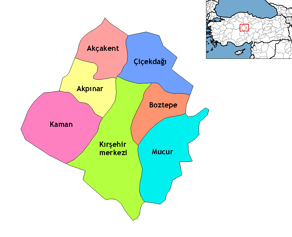
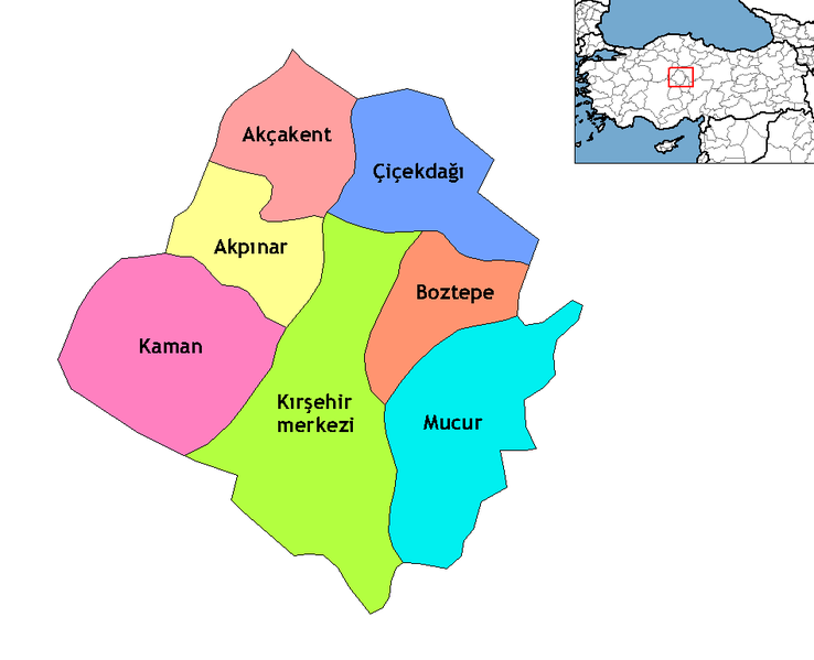
Map of the districts of Kırşehir province in Turkey. Created by Rarelibra 22:00, 1 December 2006 (UTC) for public domain use, using MapInfo Professional v8.5 and various mapping resources. Edited by One Homo Sapiens Corrected text where İ,Ş,ı,ğ,or ş occurs in name. Source: [statoids-com]. Increased font size and enhanced color differences among adjacent districts.
لائسنس –
| میں، اس کم دے کاپیرائٹ دا مالک، اس کم نوں لوکاں واسطے دیندا واں۔ اے سارے جگ واسطے لاگو اے۔ کج ملکاں چ قانونی طور تے اے ممکن نئیں اے؛ اگر انج ای اے ے: میں ہر کسے نوں اس کم نوں کسے وی مقصد واسطے ورتن دا بغیر کسے شرط دے حق دیندا واں، اگر اوہ قانون دے خلاف نا ہوۓ۔ |
فائل دی تریخ
فائل نو اس ویلے دی حالت وچ ویکھن واسطے تاریخ/ویلے تے کلک کرو۔
| تریخ تے ویلہ | نکی مورت | پاسے | ورتن والا | تیپّݨی کرو | |
|---|---|---|---|---|---|
| موجودہ | ۰۴:۲۳, ۱۷ اکتوبر ۲۰۰۹ | | ۹۴۸ × ۷۷۰ (۱۹ کلوبائٹ) | ZooFari | Trimmed off border |
| ۰۶:۱۸, ۲۹ دسمبر ۲۰۰۸ |  | ۱,۰۵۶ × ۸۱۶ (۲۰ کلوبائٹ) | One Homo Sapiens | Corrected text where İ,Ş,ı,ğ,or ş occurs in name. Source: [statoids-com]. Increased font size and enhanced color differences among adjacent districts. | |
| ۲۰:۰۱, ۱۵ اپریل ۲۰۰۷ |  | ۱,۰۵۶ × ۸۱۶ (۲۵ کلوبائٹ) | Denizz~commonswiki | == Summary == Map of the districts of Kırşehir province in Turkey. Created by Rarelibra 22:00, 1 December 2006 (UTC) for public domain use, using MapInfo Professional v8.5 and various mapping resources. == Licensing == {{PD-self}} |
فائل دی ورتوں
تھلے دتے گئے 6 صفحے اس فائل نال جُڑدے نیں
فائل ویاپک ورتوں
ایہہ دوجے وکیاں ایس فائل نوں ورتدے نیں –
- ast.wikipedia.org تے ورتوں
- azb.wikipedia.org تے ورتوں
- br.wikipedia.org تے ورتوں
- ca.wikipedia.org تے ورتوں
- ceb.wikipedia.org تے ورتوں
- de.wikipedia.org تے ورتوں
- diq.wikipedia.org تے ورتوں
- en.wikipedia.org تے ورتوں
- eo.wikipedia.org تے ورتوں
- es.wikipedia.org تے ورتوں
- eu.wikipedia.org تے ورتوں
- fa.wikipedia.org تے ورتوں
- fi.wikipedia.org تے ورتوں
- fr.wikipedia.org تے ورتوں
- fy.wikipedia.org تے ورتوں
- hu.wikipedia.org تے ورتوں
ایس فائل دا ویکھو ہور جگت ورتن .