
فائل:KKH.png

ایس وکھالے دا ناپ: ۴۱۹ × ۵۹۹ پکسلز۔ دوجے ریزولوشنز: ۱۶۸ × ۲۴۰ پکسلز | ۵۹۵ × ۸۵۱ پکسلز ۔
اصل فائل (۵۹۵ × ۸۵۱ پکسلز, فائل حجم: ۱.۴۶ میگابائٹ, MIME type: image/png)

|
This file requires updating because: Bulungkol is shown on this map but not labeled; it should be labeled. Also, the China-Tajikistan border has changed. In doing so, you could add a timestamp to the file.
|
خلاصہ
| تفصیل |
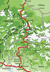
English: This is a map of Karakoram Highway, the road that links the Northern Areas of Pakistan to the Xinjiang province of China, connecting it to the old Silk Road. |
| سروت | Own work by the original uploader |
| لکھاری | de:Benutzer:Grag, User:Tevatron~commonswiki, User:Lexicon |
| دوجے ورژن |
 .png) |

|
This road map image could be re-created using vector graphics as an SVG file. This has several advantages; see Commons:Media for cleanup for more information. If an SVG form of this image is available, please upload it and afterwards replace this template with
{{vector version available|new image name}}.
It is recommended to name the SVG file “KKH.svg”—then the template Vector version available (or Vva) does not need the new image name parameter. |
لائسنس –

|
کاپی کرن، ونڈن تے بدلن دی ایس ڈوکومنٹ لئی اجازت دتی جاندی اے ایہناں GNU Free Documentation License, Version 1.2 شرطاں نال یا مگروں کسے وی چھپے ورین Free Software Foundation توں بنا کسے انویرینٹ سیکشن دے، ناں فرنٹ کور لکھت تے ناں بیک کور لکھت دے۔ لسنس دی اک کاپی سیکشن وچ ہیگی اے جہدا ناں اے GNU Free Documentation License۔ |
| ایس فائل نوں کریٹو کامنز Attribution 2.5 پولینڈ لائسنس دتا گیا. | ||
| ||
| اس لائسنس دا ٹیگ GFDL دے مطابق اس فائل چ پایا گیا اے licensing update۔ |
فائل دی تریخ
فائل نو اس ویلے دی حالت وچ ویکھن واسطے تاریخ/ویلے تے کلک کرو۔
| تریخ تے ویلہ | نکی مورت | پاسے | ورتن والا | تیپّݨی کرو | |
|---|---|---|---|---|---|
| موجودہ | ۰۸:۳۱, ۲۰ ستمبر ۲۰۰۶ | | ۵۹۵ × ۸۵۱ (۱.۴۶ میگابائٹ) | Lexicon | Attempt to fix map. |
| ۱۳:۱۷, ۱۵ اپریل ۲۰۰۶ |  | ۶۰۰ × ۸۵۶ (۱.۷۷ میگابائٹ) | Tevatron~commonswiki | from de wikipedia http://de.wikipedia.org/wiki/Bild:KKH.png == Beschreibung, Quelle und Lizenz == made with corel draw and photoshop == Lizenz == {{GFDL}} |
فائل دی ورتوں
تھلے دتے گئے 2 صفحے اس فائل نال جُڑدے نیں
فائل ویاپک ورتوں
ایہہ دوجے وکیاں ایس فائل نوں ورتدے نیں –
- ar.wikipedia.org تے ورتوں
- ba.wikipedia.org تے ورتوں
- bg.wikipedia.org تے ورتوں
- bn.wikipedia.org تے ورتوں
- ca.wikipedia.org تے ورتوں
- ceb.wikipedia.org تے ورتوں
- ckb.wikipedia.org تے ورتوں
- cs.wikipedia.org تے ورتوں
- da.wikipedia.org تے ورتوں
- de.wikipedia.org تے ورتوں
- en.wikipedia.org تے ورتوں
- en.wikivoyage.org تے ورتوں
- eo.wikipedia.org تے ورتوں
- es.wikipedia.org تے ورتوں
- eu.wikipedia.org تے ورتوں
- fa.wikipedia.org تے ورتوں
- fi.wikipedia.org تے ورتوں
- fr.wikipedia.org تے ورتوں
- ga.wikipedia.org تے ورتوں
- ha.wikipedia.org تے ورتوں
- he.wikipedia.org تے ورتوں
- hi.wikipedia.org تے ورتوں
- hu.wikipedia.org تے ورتوں
- id.wikipedia.org تے ورتوں
ایس فائل دا ویکھو ہور جگت ورتن .