
فائل:Karte Aut Stmk BM (bis 2012).png
اس توں وڈی مورت موجود نہیں۔
Karte_Aut_Stmk_BM_(bis_2012).png (۳۰۰ × ۲۰۹ پکسلز, فائل حجم: ۵ کلوبائٹ, MIME type: image/png)
.png)
خلاصہ
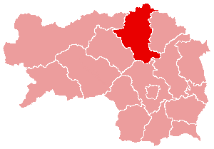
- English: Political map of the district Bruck an der Mur, Styria, Austria (until 2012)
- Deutsch: Politische Karte vom Bezirk Bruck an der Mur (bis 2012)
- drawing by de:User:plp from 2004
- Source: de.wikipedia.org: 22:37, 5. Apr 2004 . . Plp (Diskussion) . . 300 x 209 (3933 Byte)
لائسنس –

|
کاپی کرن، ونڈن تے بدلن دی ایس ڈوکومنٹ لئی اجازت دتی جاندی اے ایہناں GNU Free Documentation License, Version 1.2 شرطاں نال یا مگروں کسے وی چھپے ورین Free Software Foundation توں بنا کسے انویرینٹ سیکشن دے، ناں فرنٹ کور لکھت تے ناں بیک کور لکھت دے۔ لسنس دی اک کاپی سیکشن وچ ہیگی اے جہدا ناں اے GNU Free Documentation License۔ |
| ایس فائل نوں کریٹو کامنز Attribution 2.5 پولینڈ لائسنس دتا گیا. | ||
| ||
| اس لائسنس دا ٹیگ GFDL دے مطابق اس فائل چ پایا گیا اے licensing update۔ |
فائل دی تریخ
فائل نو اس ویلے دی حالت وچ ویکھن واسطے تاریخ/ویلے تے کلک کرو۔
| تریخ تے ویلہ | نکی مورت | پاسے | ورتن والا | تیپّݨی کرو | |
|---|---|---|---|---|---|
| موجودہ | ۱۷:۲۲, ۱۰ جنوری ۲۰۱۵ | | ۳۰۰ × ۲۰۹ (۵ کلوبائٹ) | Kontrollstellekundl | Reverted to version as of 13:29, 24 March 2012 |
| ۲۳:۵۸, ۴ جنوری ۲۰۱۵ |  | ۱,۰۰۰ × ۷۰۰ (۹۸ کلوبائٹ) | Kontrollstellekundl | Grenzen aller Bezirke ab 2015, Datei wird bei Imagemaps verwendet, deshalb für den "alten" Bezirk BM nicht mehr richtig! | |
| ۰۱:۴۱, ۷ جنوری ۲۰۱۳ |  | ۳۰۰ × ۲۰۹ (۵ کلوبائٹ) | Kontrollstellekundl | Reverted to version as of 13:29, 24 March 2012 | |
| ۲۲:۵۴, ۱ جنوری ۲۰۱۳ |  | ۳۰۰ × ۲۰۹ (۳ کلوبائٹ) | Gugganij | Merger of two districts to Bruck-Mürzzuschlag (BM) | |
| ۱۸:۲۹, ۲۴ مارچ ۲۰۱۲ |  | ۳۰۰ × ۲۰۹ (۵ کلوبائٹ) | Kontrollstellekundl | JU + KF = MT, 01.01.2012 | |
| ۰۶:۴۲, ۱۶ مارچ ۲۰۰۶ |  | ۳۰۰ × ۲۰۹ (۴ کلوبائٹ) | Inge-Lyubov~commonswiki | *{{en|Political map of the Bruck an der Mur District, Styria, Austria}} *{{de|Politische Karte von Bezirk Bruck an der Mur}} *drawing by de:User:plp from 2004 *Source: de.wikipedia.org: ''<now |
فائل دی ورتوں
تھلے دتے گئے 1 صفحے اس فائل نال جُڑدے نیں
فائل ویاپک ورتوں
ایہہ دوجے وکیاں ایس فائل نوں ورتدے نیں –
- cs.wikipedia.org تے ورتوں
- es.wikipedia.org تے ورتوں
- fa.wikipedia.org تے ورتوں
- fr.wikipedia.org تے ورتوں
- fur.wikipedia.org تے ورتوں
- ja.wikipedia.org تے ورتوں
- pl.wikipedia.org تے ورتوں
- ro.wikipedia.org تے ورتوں
- ru.wikipedia.org تے ورتوں
- sv.wikipedia.org تے ورتوں
- uz.wikipedia.org تے ورتوں
- www.wikidata.org تے ورتوں
- zh.wikipedia.org تے ورتوں
.png)