
فائل:Kingdoms around Israel 830 map.svg

Size of this PNG preview of this SVG file: ۵۰۲ × ۵۹۹ پکسلز. دوجے ریزولوشنز: ۲۰۱ × ۲۴۰ پکسلز | ۴۰۲ × ۴۸۰ پکسلز | ۶۴۴ × ۷۶۸ پکسلز | ۸۵۸ × ۱,۰۲۴ پکسلز | ۱,۷۱۷ × ۲,۰۴۸ پکسلز | ۷۲۰ × ۸۵۹ پکسلز ۔
اصل فائل (ایس وی جی فائل، پکسل:۷۲۰ × ۸۵۹، فائل سائز: ۱۲۲ کلوبائٹ)
| تفصیل |
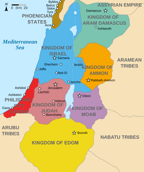
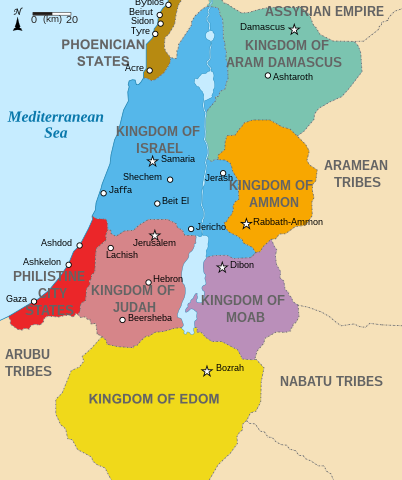
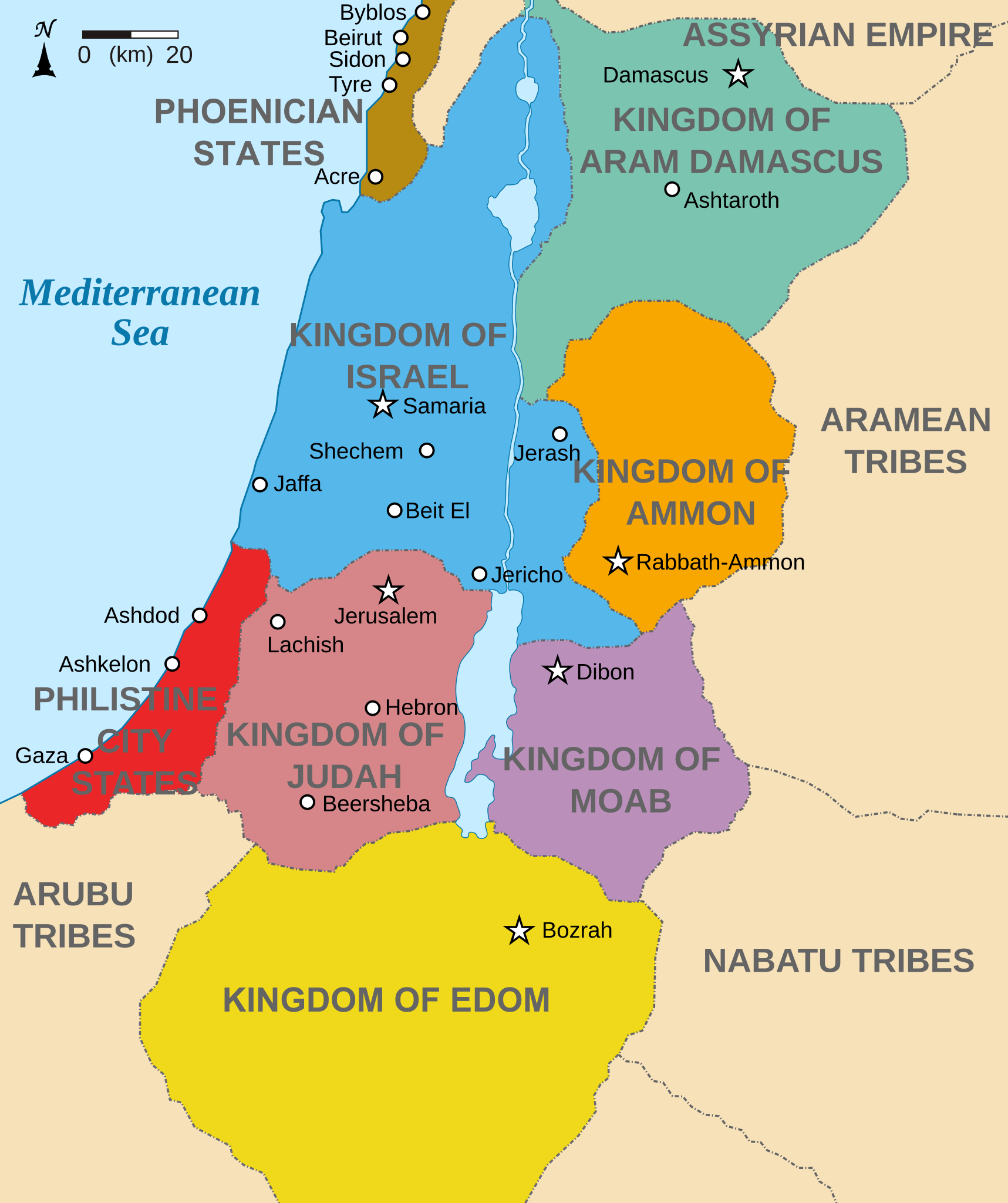
English: Map showing states around Israel & Judah. The Kingdoms around Israel & Judah are colored:
|
| تریخ | (UTC) |
| سروت | |
| لکھاری |
|
| دوجے ورژن |
[]
|


میں، اس کم دے کاپیرائٹ دا مالک، اس کم نوں اس لائسنس دے مطابق چھاپدا واں:
ایس فائل نوں کریٹو کامنز Attribution 2.5 پولینڈ لائسنس دتا گیا.
- تہانوں کھلھ اے:
- حصہ کرنا – کاپی، ونڈنا تے کم بھیجنا
- فیر رلانا – کم نوں فٹ کرنا
- تھلے دتیاں شرطاں نال:
- کس دے ناں – تسیں لازمی ایس کم دے بناں والے بارے دسو جنج اونے آکھیا اے یا جنج لسنس چ آکھیا گیا ہے۔
- اکو جہا شئیر کرو۔ – اگر تسیں بدلدے یا ایس کم تے بناندے تے بنن والے کم نوں اینج دے لسنس نال ای ونڈو گے۔

|
کاپی کرن، ونڈن تے بدلن دی ایس ڈوکومنٹ لئی اجازت دتی جاندی اے ایہناں GNU Free Documentation License, Version 1.2 شرطاں نال یا مگروں کسے وی چھپے ورین Free Software Foundation توں بنا کسے انویرینٹ سیکشن دے، ناں فرنٹ کور لکھت تے ناں بیک کور لکھت دے۔ لسنس دی اک کاپی سیکشن وچ ہیگی اے جہدا ناں اے GNU Free Documentation License۔ |
تسیں اپنی مرضی دا لائسنس چݨ سکدے اوہ۔
پہلا اپلوڈ دا ریکارڈ
This image is a derivative work of the following images:
- File:Kingdoms_of_Israel_and_Judah_map_830.svg licensed with Cc-by-sa-3.0, GFDL
- 2010-07-13T10:51:49Z Richardprins 720x859 (80858 Bytes) Added colors for the two kingdoms and converted their text to path and arial
- 2010-07-12T23:53:35Z Richardprins 720x859 (63843 Bytes) Shrinked down the borders
- 2010-07-12T19:43:31Z Richardprins 720x859 (63800 Bytes) {{Information |Description={{en|1=Map showing the ancient levant borders and ancient cities such as [[Urmomium]] and [[Jerash]]. The map also shows the region in the 9th century BCE. Notice the coastal land of Philistia, from
Uploaded with derivativeFX
فائل دی تریخ
فائل نو اس ویلے دی حالت وچ ویکھن واسطے تاریخ/ویلے تے کلک کرو۔
| تریخ تے ویلہ | نکی مورت | پاسے | ورتن والا | تیپّݨی کرو | |
|---|---|---|---|---|---|
| موجودہ | ۲۰:۳۲, ۲۹ اکتوبر ۲۰۲۲ | | ۷۲۰ × ۸۵۹ (۱۲۲ کلوبائٹ) | Muchado | Fixing font problems (hopefully) |
| ۲۰:۱۱, ۲۹ اکتوبر ۲۰۲۲ |  | ۷۲۰ × ۸۵۹ (۲۸۳ کلوبائٹ) | Muchado | Added "Philistine City States" which was unintentionally missed off... | |
| ۲۰:۰۶, ۲۹ اکتوبر ۲۰۲۲ |  | ۷۲۰ × ۸۵۹ (۲۳۹ کلوبائٹ) | Muchado | Coloured states, removed anachronistic Petra, added Bozrah, removed Urmomium (Your mom...!), edited Arabu to Arubu, edited to Philistine City States | |
| ۲۰:۵۱, ۱۰ فروری ۲۰۱۷ |  | ۷۲۰ × ۸۵۹ (۱۶۷ کلوبائٹ) | Malus Catulus | Removed 'Sizu' - a weird artifact from the Norse original | |
| ۱۷:۵۸, ۱۳ جولائی ۲۰۱۰ |  | ۷۲۰ × ۸۵۹ (۱۶۵ کلوبائٹ) | Malus Catulus | livened up the colors, converted med sea text to path | |
| ۱۶:۲۶, ۱۳ جولائی ۲۰۱۰ |  | ۷۲۰ × ۸۵۹ (۱۳۹ کلوبائٹ) | Malus Catulus | {{Information |Description={{en|1=Map showing the ancient levant borders and ancient cities such as Urmomium and Jerash. The Kingdoms around Israel and Judah are colored. The map also shows the region in the 9th century BCE. Notice the coastal lan |
فائل دی ورتوں
فائل ویاپک ورتوں
ایہہ دوجے وکیاں ایس فائل نوں ورتدے نیں –
- af.wikipedia.org تے ورتوں
- arc.wikipedia.org تے ورتوں
- ar.wikipedia.org تے ورتوں
- arz.wikipedia.org تے ورتوں
- azb.wikipedia.org تے ورتوں
- bg.wikipedia.org تے ورتوں
- bn.wikipedia.org تے ورتوں
- br.wikipedia.org تے ورتوں
- ca.wikipedia.org تے ورتوں
- cs.wikipedia.org تے ورتوں
- da.wikipedia.org تے ورتوں
- en.wikipedia.org تے ورتوں
- Ammon
- History of the ancient Levant
- Kingdom of Judah
- Kingdom of Israel (Samaria)
- Philistines
- Moab
- Philistia
- Talk:Phoenician language
- Aram-Damascus
- Edom
- Portal:Bible/Featured chapter/Psalms
- Portal:Bible/Featured chapter/Psalms 83
- User:Kazkaskazkasako/Books/History
- Transjordan (region)
- Ezekiel 25
- User:Falcaorib
- User:Jacksonmcdonald3425/sandbox
- en.wiktionary.org تے ورتوں
- eo.wikipedia.org تے ورتوں
- et.wikipedia.org تے ورتوں
- eu.wikipedia.org تے ورتوں
ایس فائل دا ویکھو ہور جگت ورتن .