
فائل:Lago Erepecu and Rio Trombetas, Brazil.jpg

ایس وکھالے دا ناپ: ۸۰۰ × ۵۳۱ پکسلز۔ دوجے ریزولوشنز: ۳۲۰ × ۲۱۲ پکسلز | ۶۴۰ × ۴۲۵ پکسلز | ۱,۰۲۴ × ۶۸۰ پکسلز | ۱,۴۴۰ × ۹۵۶ پکسلز ۔
اصل فائل (۱,۴۴۰ × ۹۵۶ پکسلز, فائل حجم: ۹۵۰ کلوبائٹ, MIME type: image/jpeg)
خلاصہ
| تفصیل |
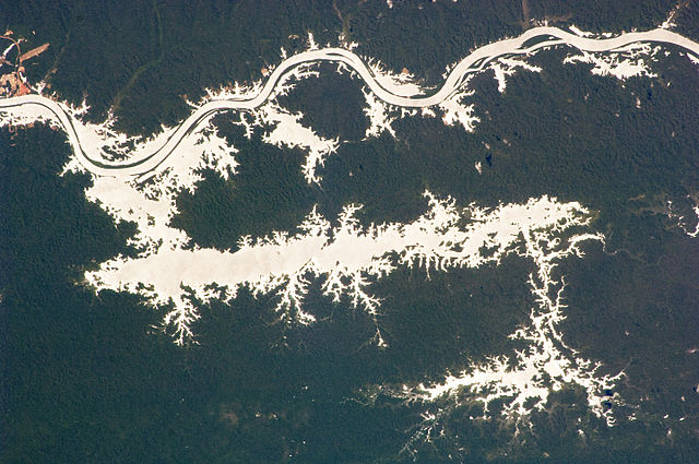
Afrikaans: Die 38 kilometer lange Erepecumeer in Brasilië loop ewewydig met die benede-Trombetasrivier, wat langs die boonste (suidelike) helfte van hierdie ruimtevaarderfoto kronkel. Waterliggame in die Amasone-reënwoud is dikwels so donker dat hulle moeilik onderskeibaar kan wees. In hierdie beeld staan die meer en rivier egter in groot detail uit in die eenvormige groen reënwoud danksy songlans op die wateroppervlak wat 'n spieëlagtige weerkaatsing na die kyker, in dié geval die ruimtevaarder aan boord van die Internasionale Ruimtestasie, lewer. Bosgrond is rooi, soos by die aanloopbaan te Porto Trombetas (heel links bo) aan 'n rivierhawe aan die suidekant van die Trombetasrivier. Let wel: Hierdie kaart is omgekeer: Noord is na onder en oos na links
English: The 38-kilometre-long Lago do Erepecu (Lake Erepecu) in Brazil runs parallel to the lower Rio Trombetas (Trombetas River), which snakes along the upper half of this astronaut photograph. Water-bodies in the Amazon Rainforest are often so dark they can be difficult to distinguish. In this image, however, the lake and river stand out from the uniform green of the forest in great detail as a result of sun-glint on the water surface. Sun-glint is the mirror-like reflection of sunlight off of a surface directly back towards the viewer, in this case an astronaut on-board the International Space Station. Forest soil is red, as shown by airfield clearings near Porto Trombetas (image far upper left), a river port on the south side of the Trombetas River. Note: This map is inverted: North is down, east is left |
| تریخ | |
| سروت | NASA Earth Observatory |
| لکھاری | NASA Expedition 20 crew. |
Image acquired with a Nikon D2Xs digital camera fitted with an 180 mm lens, and is provided by the ISS Crew Earth Observations experiment and Image Science & Analysis Laboratory, Johnson Space Centre.
لائسنس –
| This file is in the public domain in the United States because it was solely created by NASA. NASA copyright policy states that "NASA material is not protected by copyright unless noted". (See Template:PD-USGov, NASA copyright policy page or JPL Image Use Policy.) | ||
 |
Warnings:
|
| Annotations | This image is annotated: View the annotations at Commons |
فائل دی تریخ
فائل نو اس ویلے دی حالت وچ ویکھن واسطے تاریخ/ویلے تے کلک کرو۔
| تریخ تے ویلہ | نکی مورت | پاسے | ورتن والا | تیپّݨی کرو | |
|---|---|---|---|---|---|
| موجودہ | ۱۴:۵۲, ۲۱ ستمبر ۲۰۰۹ | | ۱,۴۴۰ × ۹۵۶ (۹۵۰ کلوبائٹ) | Originalwana | {{Information |Description={{en|1=The 38-kilometre-long Lago do Erepecu (Lake Erepecu) in Brazil runs parallel to the lower Rio Trombetas (Trombetas River), which snakes along the lower half of this astronaut photograph. Water-bodies in the [[Amazon R |
فائل دی ورتوں
تھلے دتے گئے 1 صفحے اس فائل نال جُڑدے نیں
فائل ویاپک ورتوں
ایہہ دوجے وکیاں ایس فائل نوں ورتدے نیں –
- arz.wikipedia.org تے ورتوں
- ceb.wikipedia.org تے ورتوں
- en.wikipedia.org تے ورتوں
- pt.wikipedia.org تے ورتوں
- vi.wikipedia.org تے ورتوں
- www.wikidata.org تے ورتوں
- zh.wikipedia.org تے ورتوں