
فائل:Lithuania territory 1939-1940.svg

Size of this PNG preview of this SVG file: ۷۶۱ × ۶۰۰ پکسلز. دوجے ریزولوشنز: ۳۰۵ × ۲۴۰ پکسلز | ۶۰۹ × ۴۸۰ پکسلز | ۹۷۴ × ۷۶۸ پکسلز | ۱,۲۸۰ × ۱,۰۰۹ پکسلز | ۲,۵۶۰ × ۲,۰۱۸ پکسلز | ۲,۴۷۹ × ۱,۹۵۴ پکسلز ۔
اصل فائل (ایس وی جی فائل، پکسل:۲,۴۷۹ × ۱,۹۵۴، فائل سائز: ۲۱۱ کلوبائٹ)
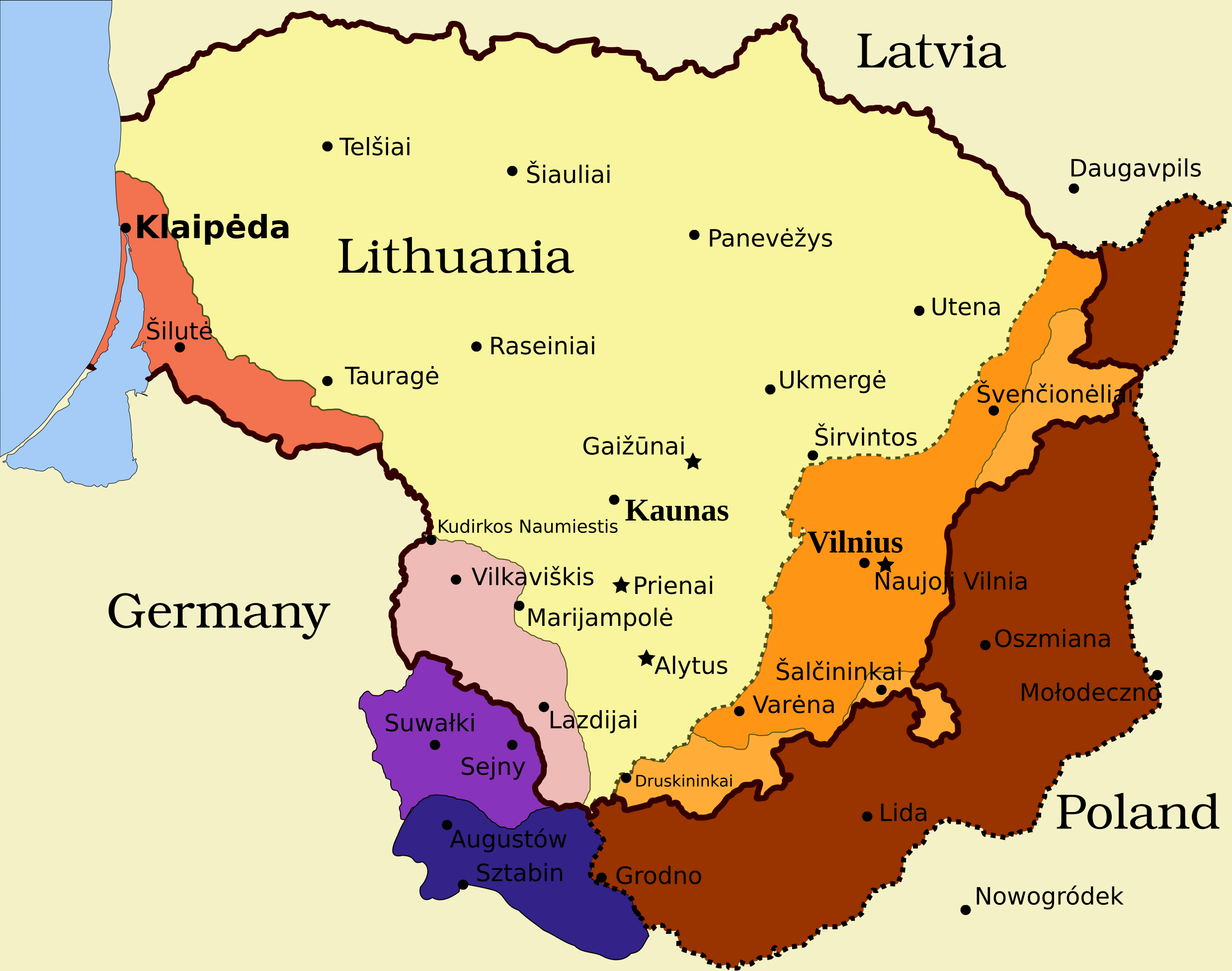
Legend
- Borders and other
Border of Lithuania (1945 – present)
Border of Vilnius Region: Polish territory; claimed by Lithuania based on the Soviet–Lithuania Peace Treaty of 1920; occupied by the Soviet Union in September 1939
![]() Soviet military bases established in Lithuania according to the Soviet–Lithuania Mutual Assistance Treaty, signed on October 10, 1939
Soviet military bases established in Lithuania according to the Soviet–Lithuania Mutual Assistance Treaty, signed on October 10, 1939
- Klaipėda Region
Klaipėda Region: detached from the German Empire by the Treaty of Versailles; placed under administration of the Entente; taken by Lithuanians during the Klaipėda Revolt in January 1923; returned to Nazi Germany after an ultimatum on March 20, 1939
- Sudovia
Territory west of the Šešupė River: Lithuanian territory; requested by Nazi Germany in the German-Soviet Boundary and Friendship Treaty on September 28, 1939; occupied by the Soviet Union on June 15, 1940; Nazi Germany relinquished its claims for a compensation in the amount of $7.5 million on January 10, 1941
"Suwałki Triangle": Polish territory; claimed by Lithuania; occupied by Nazi Germany in September 1939
Southern Suvalkai Region: Polish territory; claimed by Lithuania; occupied by the Soviet Union in September 1939
Vilnius Region
Western Vilnius Region: transferred to Lithuania based on the Soviet–Lithuania Mutual Assistance Treaty, signed on October 10, 1939
Western Vilnius Region: transferred to Lithuanian SSR on November 6, 1940
Eastern Vilnius Region: by Soviet–Lithuanian Peace Treaty assigned to Lithuania in July 12, 1920
خلاصہ
| تفصیل | Map of territorial disputes and claims regarding Lithuania in 1939-1940 |
| تریخ | |
| سروت | Self-made using Inkscape; used Image:LithuaniaPhysicalMap-Clean.svg by Knutux for some background features; Source map: (2001) Lietuvos istorijos atlasas, Vilnius: Vaga, p. 44 & 45 |
| لکھاری |
This W3C-unspecified vector image was created with Inkscape . |
| اجازت (فائل نوں دوبارہ ورتنا) |
GFDL & all CC-BY-SA |
| دوجے ورژن |
[]
|


لائسنس –
میں، اس کم دے کاپیرائٹ دا مالک، اس کم نوں اس لائسنس دے مطابق چھاپدا واں:

|
کاپی کرن، ونڈن تے بدلن دی ایس ڈوکومنٹ لئی اجازت دتی جاندی اے ایہناں GNU Free Documentation License, Version 1.2 شرطاں نال یا مگروں کسے وی چھپے ورین Free Software Foundation توں بنا کسے انویرینٹ سیکشن دے، ناں فرنٹ کور لکھت تے ناں بیک کور لکھت دے۔ لسنس دی اک کاپی سیکشن وچ ہیگی اے جہدا ناں اے GNU Free Documentation License۔ |
This file is licensed under the Creative Commons Attribution-Share Alike 4.0 International, 3.0 Unported, 2.5 Generic, 2.0 Generic and 1.0 Generic license.
- تہانوں کھلھ اے:
- حصہ کرنا – کاپی، ونڈنا تے کم بھیجنا
- فیر رلانا – کم نوں فٹ کرنا
- تھلے دتیاں شرطاں نال:
- کس دے ناں – تسیں لازمی ایس کم دے بناں والے بارے دسو جنج اونے آکھیا اے یا جنج لسنس چ آکھیا گیا ہے۔
- اکو جہا شئیر کرو۔ – اگر تسیں بدلدے یا ایس کم تے بناندے تے بنن والے کم نوں اینج دے لسنس نال ای ونڈو گے۔
تسیں اپنی مرضی دا لائسنس چݨ سکدے اوہ۔
فائل دی تریخ
فائل نو اس ویلے دی حالت وچ ویکھن واسطے تاریخ/ویلے تے کلک کرو۔
| تریخ تے ویلہ | نکی مورت | پاسے | ورتن والا | تیپّݨی کرو | |
|---|---|---|---|---|---|
| موجودہ | ۱۶:۱۳, ۲۷ مارچ ۲۰۲۴ | | ۲,۴۷۹ × ۱,۹۵۴ (۲۱۱ کلوبائٹ) | X3SNW8 | File uploaded using svgtranslate tool (https://svgtranslate.toolforge.org/). Added translation for it. |
| ۱۹:۳۸, ۲۰ اگست ۲۰۱۰ |  | ۲,۴۷۹ × ۱,۹۵۴ (۲۰۷ کلوبائٹ) | Tomasz Bladyniec | 1. There was an error in the name of one of villages. "Graizunai" should be "Gaizunai". 2. If the southeastern territory is decribed as Poland, names of cities should be in Polish then, as they were those times. 3. There's no need to write "Nazi Germany". | |
| ۰۳:۳۵, ۳۱ مارچ ۲۰۰۸ |  | ۲,۴۷۹ × ۱,۹۵۴ (۲۰۳ کلوبائٹ) | Renata3 | get rid of legend - too bulky in articles | |
| ۰۲:۳۵, ۳۱ مارچ ۲۰۰۸ |  | ۳,۲۹۰ × ۱,۹۵۴ (۲۲۶ کلوبائٹ) | Fvasconcellos | layers | |
| ۱۹:۲۲, ۲۹ مارچ ۲۰۰۸ |  | ۳,۲۹۰ × ۱,۹۵۴ (۲۲۳ کلوبائٹ) | Fvasconcellos | font fixes | |
| ۱۹:۱۰, ۲۹ مارچ ۲۰۰۸ |  | ۳,۲۹۰ × ۱,۹۵۴ (۲۱۰ کلوبائٹ) | Fvasconcellos | one more attempt | |
| ۲۱:۵۸, ۲۸ مارچ ۲۰۰۸ |  | ۳,۲۹۰ × ۱,۹۵۴ (۲۲۶ کلوبائٹ) | Mangwanani | tried to fix image | |
| ۲۱:۲۸, ۲۸ مارچ ۲۰۰۸ |  | ۳,۲۹۰ × ۱,۹۵۴ (۲۲۶ کلوبائٹ) | Renata3 | {{Information |Description=Map of territorial disputes and claims regarding Lithuania in 1939-1940 |Source=Self-made using Inkscape; used Image:LithuaniaPhysicalMap-Clean.svg by Knutux for some background features; Source map: (2001) ''Lietuvos istor |
فائل دی ورتوں
تھلے دتے گئے 1 صفحے اس فائل نال جُڑدے نیں
فائل ویاپک ورتوں
ایہہ دوجے وکیاں ایس فائل نوں ورتدے نیں –
- ar.wikipedia.org تے ورتوں
- az.wikipedia.org تے ورتوں
- be-tarask.wikipedia.org تے ورتوں
- be.wikipedia.org تے ورتوں
- bg.wikipedia.org تے ورتوں
- bn.wikipedia.org تے ورتوں
- ca.wikipedia.org تے ورتوں
- cs.wikipedia.org تے ورتوں
- el.wikipedia.org تے ورتوں
- en.wikipedia.org تے ورتوں
- History of Lithuania
- Molotov–Ribbentrop Pact
- Vilnius Region
- Portal:Lithuania
- Talk:Sejny Uprising
- 1938 Polish ultimatum to Lithuania
- Wikipedia:Graphics Lab/Images to improve/Archive/Apr 2008
- Wikipedia:Articles for deletion/Log/2008 April 18
- Wikipedia:Articles for deletion/Suvalkai Region
- Soviet–Lithuanian Mutual Assistance Treaty
- German–Soviet Border and Commercial Agreement
- German occupation of Lithuania during World War II
- Soviet ultimatum to Lithuania
- Talk:Sejny Uprising/GA1
- Talk:The Holocaust in Poland/Archives/2018/April
- User:Falcaorib
- User:Artemis Andromeda/sandbox/Republic of Lithuania (1918–1940)
- es.wikipedia.org تے ورتوں
- et.wikipedia.org تے ورتوں
- fa.wikipedia.org تے ورتوں
- fi.wikipedia.org تے ورتوں
- fr.wikipedia.org تے ورتوں
- hy.wikipedia.org تے ورتوں
- id.wikipedia.org تے ورتوں
ایس فائل دا ویکھو ہور جگت ورتن .