
فائل:LocationMalayPeninsula.png
اس توں وڈی مورت موجود نہیں۔
LocationMalayPeninsula.png (۲۵۰ × ۱۱۵ پکسلز, فائل حجم: ۵ کلوبائٹ, MIME type: image/png)
خلاصہ
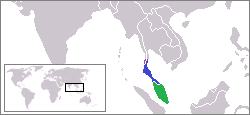
| تفصیل |
English: Map of SE Asia with Malay Peninsula highlighted |
| تریخ | انجان تاریخ |
| سروت | آپݨا کم |
| لکھاری | Ahoerstemeier |
لائسنس –

|
کاپی کرن، ونڈن تے بدلن دی ایس ڈوکومنٹ لئی اجازت دتی جاندی اے ایہناں GNU Free Documentation License, Version 1.2 شرطاں نال یا مگروں کسے وی چھپے ورین Free Software Foundation توں بنا کسے انویرینٹ سیکشن دے، ناں فرنٹ کور لکھت تے ناں بیک کور لکھت دے۔ لسنس دی اک کاپی سیکشن وچ ہیگی اے جہدا ناں اے GNU Free Documentation License۔ |
| ایس فائل نوں کریٹو کامنز Attribution 2.5 پولینڈ لائسنس دتا گیا. | ||
| ||
| اس لائسنس دا ٹیگ GFDL دے مطابق اس فائل چ پایا گیا اے licensing update۔ |
ایس فائل نوں کریٹو کامنز Attribution 1.0 جنرک لائسنس دتا گیا.
- تہانوں کھلھ اے:
- حصہ کرنا – کاپی، ونڈنا تے کم بھیجنا
- فیر رلانا – کم نوں فٹ کرنا
- تھلے دتیاں شرطاں نال:
- کس دے ناں – تسیں لازمی ایس کم دے بناں والے بارے دسو جنج اونے آکھیا اے یا جنج لسنس چ آکھیا گیا ہے۔
- اکو جہا شئیر کرو۔ – If you alter, transform, or build upon this work, you must distribute the resulting work under the same license as the original.
فائل دی تریخ
فائل نو اس ویلے دی حالت وچ ویکھن واسطے تاریخ/ویلے تے کلک کرو۔
| تریخ تے ویلہ | نکی مورت | پاسے | ورتن والا | تیپّݨی کرو | |
|---|---|---|---|---|---|
| موجودہ | ۱۵:۰۴, ۱۶ فروری ۲۰۱۹ | | ۲۵۰ × ۱۱۵ (۵ کلوبائٹ) | Whisper of the heart | / |
| ۲۲:۱۳, ۲۹ اگست ۲۰۰۹ |  | ۲۵۰ × ۱۱۵ (۴ کلوبائٹ) | Carnby | I corrected the upper border of the Malay peninsula putting it at Kra Isthmus. | |
| ۲۱:۳۶, ۱۴ جون ۲۰۰۵ |  | ۲۵۰ × ۱۱۵ (۳ کلوبائٹ) | Ahoerstemeier | Map of SE Asia with the Malay Peninsular highlighted. {{GFDL}} {{cc-by-sa}} Category:Maps of Thailand |
فائل دی ورتوں
تھلے دتے گئے 1 صفحے اس فائل نال جُڑدے نیں
فائل ویاپک ورتوں
ایہہ دوجے وکیاں ایس فائل نوں ورتدے نیں –
- af.wikipedia.org تے ورتوں
- ar.wikipedia.org تے ورتوں
- az.wikipedia.org تے ورتوں
- bg.wikipedia.org تے ورتوں
- bn.wikipedia.org تے ورتوں
- ca.wikipedia.org تے ورتوں
- ceb.wikipedia.org تے ورتوں
- cs.wikipedia.org تے ورتوں
- cv.wikipedia.org تے ورتوں
- da.wikipedia.org تے ورتوں
- de.wikipedia.org تے ورتوں
- de.wikinews.org تے ورتوں
- el.wikipedia.org تے ورتوں
- el.wiktionary.org تے ورتوں
- en.wikipedia.org تے ورتوں
- eo.wikipedia.org تے ورتوں
- es.wikipedia.org تے ورتوں
- et.wikipedia.org تے ورتوں
- fa.wikipedia.org تے ورتوں
- fi.wikipedia.org تے ورتوں
- fo.wikipedia.org تے ورتوں
- fr.wikipedia.org تے ورتوں
- fy.wikipedia.org تے ورتوں
- gl.wikipedia.org تے ورتوں
- hak.wikipedia.org تے ورتوں
- hi.wikipedia.org تے ورتوں
- hr.wikipedia.org تے ورتوں
- hu.wikipedia.org تے ورتوں
- hy.wikipedia.org تے ورتوں
- ilo.wikipedia.org تے ورتوں
- incubator.wikimedia.org تے ورتوں
- is.wikipedia.org تے ورتوں
- it.wikipedia.org تے ورتوں
- ja.wikipedia.org تے ورتوں
ایس فائل دا ویکھو ہور جگت ورتن .