
فائل:Location Tumen-River.png
اس توں وڈی مورت موجود نہیں۔
Location_Tumen-River.png (۴۸۹ × ۳۳۷ پکسلز, فائل حجم: ۱۱۱ کلوبائٹ, MIME type: image/png)
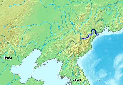
English: The Tumen River is a long river that serves as part of the boundary between China, North Korea, and the Russian Federation.
- Русский: ru:Туманная (река) - река на Дальнем Востоке, по которой проходят границы России, КНДР и Китая.
This image is in the public domain because it came from the site https://www.demis.nl/products/web-map-server/examples/ and was released by the copyright holder. Permission is granted to copy, distribute and/or modify this map since it is based on free of copyright images from: www.demis.nl. See also approval email on de.wp and its clarification.
|
| This work has been released into the public domain by its copyright holder, www.demis.nl. This applies worldwide. کج ملکاں چ قانونی طور تے اے ممکن نئیں اے؛ اگر انج ای اے ے: www.demis.nl ہر کسے نوں اس کم نوں کسے وی مقصد واسطے ورتن دا بغیر کسے شرط دے حق دیندا واں، اگر اوہ قانون دے خلاف نا ہوۓ۔
|
فائل دی تریخ
فائل نو اس ویلے دی حالت وچ ویکھن واسطے تاریخ/ویلے تے کلک کرو۔
| تریخ تے ویلہ | نکی مورت | پاسے | ورتن والا | تیپّݨی کرو | |
|---|---|---|---|---|---|
| موجودہ | ۲۰:۱۶, ۱۳ جنوری ۲۰۰۷ | | ۴۸۹ × ۳۳۷ (۱۱۱ کلوبائٹ) | Kaba | en:Tumen River is a long river that serves as part of the boundary between en:China, en:North Korea, and the [:en:Russian Federation|]]. ja:豆満江はは中朝国境のja:白頭山に源流を発し、ja:中国、[[:ja |
فائل دی ورتوں
تھلے دتے گئے 1 صفحے اس فائل نال جُڑدے نیں
فائل ویاپک ورتوں
ایہہ دوجے وکیاں ایس فائل نوں ورتدے نیں –
- af.wikipedia.org تے ورتوں
- ar.wikipedia.org تے ورتوں
- azb.wikipedia.org تے ورتوں
- bn.wikipedia.org تے ورتوں
- br.wikipedia.org تے ورتوں
- ckb.wikipedia.org تے ورتوں
- cs.wikipedia.org تے ورتوں
- de.wikipedia.org تے ورتوں
- en.wikipedia.org تے ورتوں
- en.wikinews.org تے ورتوں
- es.wikipedia.org تے ورتوں
- fa.wikipedia.org تے ورتوں
- fi.wikipedia.org تے ورتوں
- fi.wikinews.org تے ورتوں
- fr.wikipedia.org تے ورتوں
- he.wikipedia.org تے ورتوں
- hi.wikipedia.org تے ورتوں
- hu.wikipedia.org تے ورتوں
- id.wikipedia.org تے ورتوں
- it.wikipedia.org تے ورتوں
- ja.wikipedia.org تے ورتوں
- jv.wikipedia.org تے ورتوں
- ko.wikipedia.org تے ورتوں
- mk.wikipedia.org تے ورتوں
- ml.wikipedia.org تے ورتوں
- mn.wikipedia.org تے ورتوں
- nl.wikipedia.org تے ورتوں
- nn.wikipedia.org تے ورتوں
- no.wikipedia.org تے ورتوں
- oc.wikipedia.org تے ورتوں
- pa.wikipedia.org تے ورتوں
- pl.wikipedia.org تے ورتوں
- pt.wikipedia.org تے ورتوں
- ru.wikipedia.org تے ورتوں
- sh.wikipedia.org تے ورتوں
- sv.wikipedia.org تے ورتوں
- th.wikipedia.org تے ورتوں
- vi.wikipedia.org تے ورتوں
- zh-min-nan.wikipedia.org تے ورتوں
- zh-yue.wikipedia.org تے ورتوں
ایس فائل دا ویکھو ہور جگت ورتن .