
فائل:Mapa ilustrado del Reino de España y sus posesiones para la Guardia Civil.jpg

ایس وکھالے دا ناپ: ۷۷۶ × ۶۰۰ پکسلز۔ دوجے ریزولوشنز: ۳۱۱ × ۲۴۰ پکسلز | ۶۲۱ × ۴۸۰ پکسلز | ۹۹۴ × ۷۶۸ پکسلز | ۱,۲۸۰ × ۹۸۹ پکسلز | ۲,۵۶۰ × ۱,۹۷۸ پکسلز | ۸,۱۷۳ × ۶,۳۱۶ پکسلز ۔
اصل فائل (۸,۱۷۳ × ۶,۳۱۶ پکسلز, فائل حجم: ۳۸.۶۶ میگابائٹ, MIME type: image/jpeg)
خلاصہ
| تفصیل |
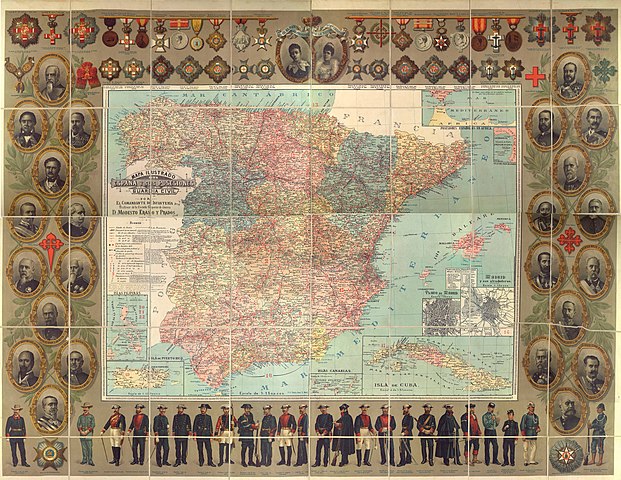
English: Illustrated map of the Kingdom of Spain and its remaining colonial posessions (Spanish Guinea, Spanish Sahara and Spanish Morocco not included) in 1895, prior to the Spanish-American War. This map was produced for the Guardia Civil (Gendarmerie of Spain) and so includes the portraits of the directors of the Guardia Civil. It also includes the different decorations available at the time.
Español: Mapa ilustrado del Reino de España y sus posesiones coloniales (Guinea, Sáhara y Marruecos no incluidas) en 1895, antes de la Guerra hispano-estadounidense. Este mapa fue producido para la Guardia Civil y por lo tanto incluye los retratos de los directores de la Guardia Civil. También incluye las diferentes condecoraciones existentes en dicha época. |
| تریخ | |
| سروت | [1] |
| لکھاری | Eraso y Prados, Modesto |
لائسنس –
| ایس فائل نوں ایہ لسنس کریٹو کامنز CC0 1.0 یونیورسل پبلک ڈومین ڈیڈیکیشن دتا گیا اے۔ | |
| اوہ بندا جینے اے کم کیتا اے اونے اے کم public domain دے ناں لایا اے تے سارے حقاں نوں چھڈ دتا اے۔ تسیں اینو کاروبار کم لئی ورت سکدے اے یا بدل سکدے او بنا کسے اجازت دے۔
|
فائل دی تریخ
فائل نو اس ویلے دی حالت وچ ویکھن واسطے تاریخ/ویلے تے کلک کرو۔
| تریخ تے ویلہ | نکی مورت | پاسے | ورتن والا | تیپّݨی کرو | |
|---|---|---|---|---|---|
| موجودہ | ۱۶:۲۹, ۲۵ اپریل ۲۰۱۸ | | ۸,۱۷۳ × ۶,۳۱۶ (۳۸.۶۶ میگابائٹ) | Helomer | User created page with UploadWizard |
فائل دی ورتوں
تھلے دتے گئے 1 صفحے اس فائل نال جُڑدے نیں
فائل ویاپک ورتوں
ایہہ دوجے وکیاں ایس فائل نوں ورتدے نیں –
- azb.wikipedia.org تے ورتوں
- en.wikipedia.org تے ورتوں
- eu.wikipedia.org تے ورتوں
- ur.wikipedia.org تے ورتوں