
فائل:NEO lake jau big.jpg

ایس وکھالے دا ناپ: ۶۰۰ × ۶۰۰ پکسلز۔ دوجے ریزولوشنز: ۲۴۰ × ۲۴۰ پکسلز | ۴۸۰ × ۴۸۰ پکسلز | ۷۵۰ × ۷۵۰ پکسلز ۔
اصل فائل (۷۵۰ × ۷۵۰ پکسلز, فائل حجم: ۱۳۴ کلوبائٹ, MIME type: image/jpeg)
خلاصہ
| تفصیل |
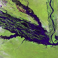
English: The Negro River flowing through the eastern edge of Brazil’s Jau National Park. The river is the big strip of blue running from left to right across the image, and the other blue ribbons are tributaries. Originating at the border of Venezuela and Brazil, the Negro River meets up with the Amazon in central Brazil to become its largest tributary. Half-submerged islands can be seen in the center of the river. Between November and April when the river is at its peak, many of these islands disappear. |
| تریخ | |
| سروت |
http://earthobservatory.nasa.gov/Newsroom/NewImages/images.php3?img_id=10843
|
| لکھاری | NASA and USGS EROS Data Center Satellite Systems Branch |
لائسنس –
This image is in the public domain in the United States because it only contains materials that originally came from the United States Geological Survey, an agency of the United States Department of the Interior. For more information, see the official USGS copyright policy.
|
پہلا اپلوڈ دا ریکارڈ
The original description page was here. All following user names refer to en.wikipedia.
- 2003-11-23 05:55 Snoyes 750×750×8 (136760 bytes)
فائل دی تریخ
فائل نو اس ویلے دی حالت وچ ویکھن واسطے تاریخ/ویلے تے کلک کرو۔
| تریخ تے ویلہ | نکی مورت | پاسے | ورتن والا | تیپّݨی کرو | |
|---|---|---|---|---|---|
| موجودہ | ۰۱:۲۷, ۵ اپریل ۲۰۰۸ | | ۷۵۰ × ۷۵۰ (۱۳۴ کلوبائٹ) | File Upload Bot (Magnus Manske) | {{BotMoveToCommons|en.wikipedia}} {{Information |Description={{en|'''Credit(s):''' [http://edc.usgs.gov/ USGS EROS Data Center] Satellite Systems Branch. '''Source:''' http://earthobservatory.nasa.gov/Newsroom/NewImages/images.php3?img_id=10843 ''?The |
فائل دی ورتوں
تھلے دتے گئے 1 صفحے اس فائل نال جُڑدے نیں
فائل ویاپک ورتوں
ایہہ دوجے وکیاں ایس فائل نوں ورتدے نیں –
- ar.wikipedia.org تے ورتوں
- ast.wikipedia.org تے ورتوں
- ba.wikipedia.org تے ورتوں
- be.wikipedia.org تے ورتوں
- bg.wikipedia.org تے ورتوں
- ca.wikipedia.org تے ورتوں
- de.wikipedia.org تے ورتوں
- de.wikivoyage.org تے ورتوں
- en.wikipedia.org تے ورتوں
- es.wikipedia.org تے ورتوں
- eu.wikipedia.org تے ورتوں
- fr.wikipedia.org تے ورتوں
- he.wikipedia.org تے ورتوں
- he.wikivoyage.org تے ورتوں
- hi.wikipedia.org تے ورتوں
- hr.wikipedia.org تے ورتوں
- id.wikipedia.org تے ورتوں
- it.wikivoyage.org تے ورتوں
- ja.wikipedia.org تے ورتوں
- ka.wikipedia.org تے ورتوں
- ko.wikipedia.org تے ورتوں
- lt.wikipedia.org تے ورتوں
- mai.wikipedia.org تے ورتوں
- ml.wikipedia.org تے ورتوں
- mt.wikipedia.org تے ورتوں
- ne.wikipedia.org تے ورتوں
- nl.wikipedia.org تے ورتوں
- pl.wikipedia.org تے ورتوں
ایس فائل دا ویکھو ہور جگت ورتن .