
فائل:Nam-Viet 200bc.jpg
ایس وکھالے دا ناپ: ۷۲۸ × ۵۹۹ پکسلز۔ دوجے ریزولوشنز: ۲۹۲ × ۲۴۰ پکسلز | ۵۸۳ × ۴۸۰ پکسلز | ۹۳۳ × ۷۶۸ پکسلز | ۱,۱۶۶ × ۹۶۰ پکسلز ۔
اصل فائل (۱,۱۶۶ × ۹۶۰ پکسلز, فائل حجم: ۸۵۶ کلوبائٹ, MIME type: image/jpeg)

|
This historical map image could be re-created using vector graphics as an SVG file. This has several advantages; see Commons:Media for cleanup for more information. If an SVG form of this image is available, please upload it and afterwards replace this template with
{{vector version available|new image name}}.
It is recommended to name the SVG file “Nam-Viet 200bc.svg”—then the template Vector version available (or Vva) does not need the new image name parameter. |


خلاصہ
| تفصیل |
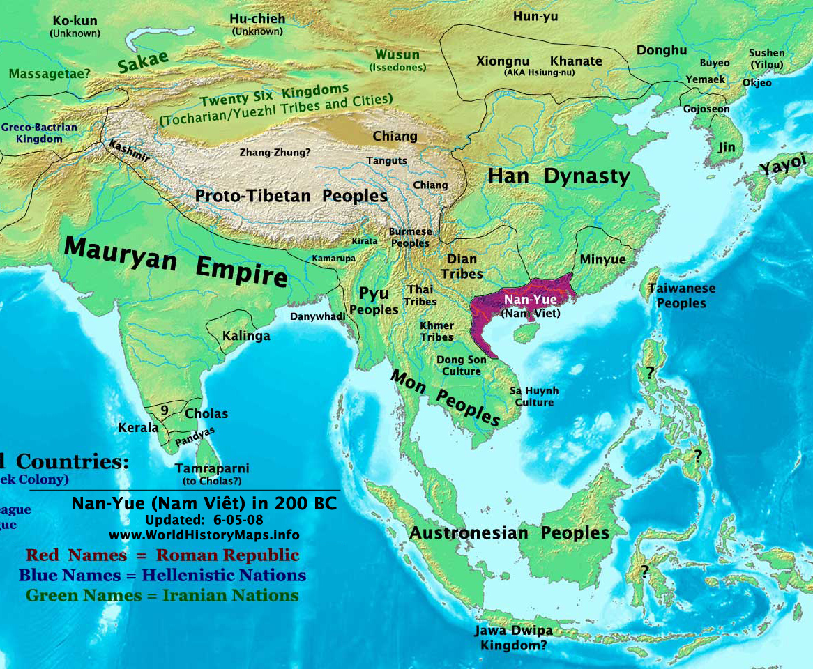
English: Map of ancient Nam Việt (204 BCE - 111 BCE) - an ancient kingdom that consisted of parts of the modern southern Chinese provinces of Guangdong, Guangxi, Yunnan and northern Vietnam.
|
| تریخ | ۱۰ جولائی ۲۰۰۹ (original upload date) |
| سروت | Transferred from en.wikipedia to Commons by Alagos. |
| لکھاری | The original uploader was Sea888 at English وکیپیڈیا. |
لائسنس –
ایس فائل نوں کریٹو کامنز Attribution 2.5 پولینڈ لائسنس دتا گیا.
- تہانوں کھلھ اے:
- حصہ کرنا – کاپی، ونڈنا تے کم بھیجنا
- فیر رلانا – کم نوں فٹ کرنا
- تھلے دتیاں شرطاں نال:
- کس دے ناں – تسیں لازمی ایس کم دے بناں والے بارے دسو جنج اونے آکھیا اے یا جنج لسنس چ آکھیا گیا ہے۔
- اکو جہا شئیر کرو۔ – اگر تسیں بدلدے یا ایس کم تے بناندے تے بنن والے کم نوں اینج دے لسنس نال ای ونڈو گے۔
پہلا اپلوڈ دا ریکارڈ
The original description page was here. All following user names refer to en.wikipedia.
Upload date | User | Bytes | Dimensions | Comment
- 2009-07-10 19:33:35 | Sea888 | 876342 | 1166×960 | Author: Thomas A. Lessman. Source URL: http://www.worldhistorymaps.info/maps.html. Image was created by me (Thomas Lessman) based on map of Eastern Hemisphere in 200 BC. Image is free for public and/or educational use. I would appreciate a mention if this
فائل دی تریخ
فائل نو اس ویلے دی حالت وچ ویکھن واسطے تاریخ/ویلے تے کلک کرو۔
| تریخ تے ویلہ | نکی مورت | پاسے | ورتن والا | تیپّݨی کرو | |
|---|---|---|---|---|---|
| موجودہ | ۲۰:۲۷, ۵ جنوری ۲۰۱۳ | | ۱,۱۶۶ × ۹۶۰ (۸۵۶ کلوبائٹ) | Alagos | {{CH2MoveToCommons|en.wikipedia|year={{subst:CURRENTYEAR}}|month={{subst:CURRENTMONTHNAME}}|day={{subst:CURRENTDAY}}}} The tool and the bot are operated by User:Jan Luca and User:Magnus Manske. =={{int:filedesc}}== {{Information |description=A... |
فائل دی ورتوں
تھلے دتے گئے 1 صفحے اس فائل نال جُڑدے نیں
فائل ویاپک ورتوں
ایہہ دوجے وکیاں ایس فائل نوں ورتدے نیں –
- ast.wikipedia.org تے ورتوں
- bcl.wikipedia.org تے ورتوں
- bn.wikipedia.org تے ورتوں
- en.wikipedia.org تے ورتوں
- es.wikipedia.org تے ورتوں
- eu.wikipedia.org تے ورتوں
- fi.wikipedia.org تے ورتوں
- fr.wikipedia.org تے ورتوں
- id.wikipedia.org تے ورتوں
- ja.wikipedia.org تے ورتوں
- pt.wikipedia.org تے ورتوں
- ru.wikipedia.org تے ورتوں
- th.wikipedia.org تے ورتوں
- uk.wikipedia.org تے ورتوں
- ur.wikipedia.org تے ورتوں
- vi.wikipedia.org تے ورتوں