
فائل:North India Opinion Map 1.png
اس توں وڈی مورت موجود نہیں۔
North_India_Opinion_Map_1.png (۵۱۴ × ۶۰۰ پکسلز, فائل حجم: ۱۶۴ کلوبائٹ, MIME type: image/png)
| تفصیل |
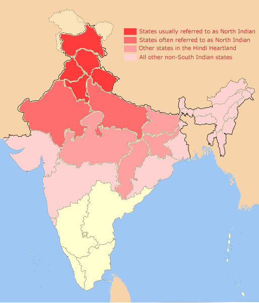
English: The perception on what constitues North India varies from source to source. The states shown in darkest red are usually included, while others are included to varying degrees and may or may not be considered part of present-day North India. |
| تریخ | (UTC) |
| سروت | |
| لکھاری |
|
| This is a retouched picture, which means that it has been digitally altered from its original version. The original can be viewed here: North-India-locator.png:
|
میں، اس کم دے کاپیرائٹ دا مالک، اس کم نوں اس لائسنس دے مطابق چھاپدا واں:
ایس فائل نوں کریٹو کامنز Attribution 2.5 پولینڈ لائسنس دتا گیا.
- تہانوں کھلھ اے:
- حصہ کرنا – کاپی، ونڈنا تے کم بھیجنا
- فیر رلانا – کم نوں فٹ کرنا
- تھلے دتیاں شرطاں نال:
- کس دے ناں – تسیں لازمی ایس کم دے بناں والے بارے دسو جنج اونے آکھیا اے یا جنج لسنس چ آکھیا گیا ہے۔
- اکو جہا شئیر کرو۔ – اگر تسیں بدلدے یا ایس کم تے بناندے تے بنن والے کم نوں اینج دے لسنس نال ای ونڈو گے۔

|
کاپی کرن، ونڈن تے بدلن دی ایس ڈوکومنٹ لئی اجازت دتی جاندی اے ایہناں GNU Free Documentation License, Version 1.2 شرطاں نال یا مگروں کسے وی چھپے ورین Free Software Foundation توں بنا کسے انویرینٹ سیکشن دے، ناں فرنٹ کور لکھت تے ناں بیک کور لکھت دے۔ لسنس دی اک کاپی سیکشن وچ ہیگی اے جہدا ناں اے GNU Free Documentation License۔ |
تسیں اپنی مرضی دا لائسنس چݨ سکدے اوہ۔
پہلا اپلوڈ دا ریکارڈ
This image is a derivative work of the following images:
- Image:North-India-locator.png licensed with Cc-by-sa-3.0, GFDL
- 2008-07-12T02:01:46Z Fundamental metric tensor 514x600 (79143 Bytes) {{Information |Description={{en|1=North Indian states + areas under their cultural influence}} |Source=Own work by uploader |Author=[[User:Fundamental metric tensor|Fundamental metric tensor]] |Date= |Permission= |other_versi
Uploaded with derivativeFX
فائل دی تریخ
فائل نو اس ویلے دی حالت وچ ویکھن واسطے تاریخ/ویلے تے کلک کرو۔
| تریخ تے ویلہ | نکی مورت | پاسے | ورتن والا | تیپّݨی کرو | |
|---|---|---|---|---|---|
| موجودہ | ۰۷:۳۱, ۲۴ اکتوبر ۲۰۰۸ | | ۵۱۴ × ۶۰۰ (۱۶۴ کلوبائٹ) | Hunnjazal | {{Information |Description={{en|1=The perception on what constitues North India varies from source to source. The states shown in darkest red are usually included, while others are included to varying degrees and may or may not be considered part of prese |
فائل دی ورتوں
اس فائل نال جڑیا کوئی صفحہ نئیں۔
فائل ویاپک ورتوں
ایہہ دوجے وکیاں ایس فائل نوں ورتدے نیں –
- en.wikipedia.org تے ورتوں
- ja.wikipedia.org تے ورتوں