
فائل:O'Hare International Airport (USGS).png
ایس وکھالے دا ناپ: ۴۸۸ × ۵۹۹ پکسلز۔ دوجے ریزولوشنز: ۱۹۵ × ۲۴۰ پکسلز | ۳۹۱ × ۴۸۰ پکسلز | ۷۴۳ × ۹۱۲ پکسلز ۔
اصل فائل (۷۴۳ × ۹۱۲ پکسلز, فائل حجم: ۱.۵۶ میگابائٹ, MIME type: image/png)
.png)
| تفصیل |
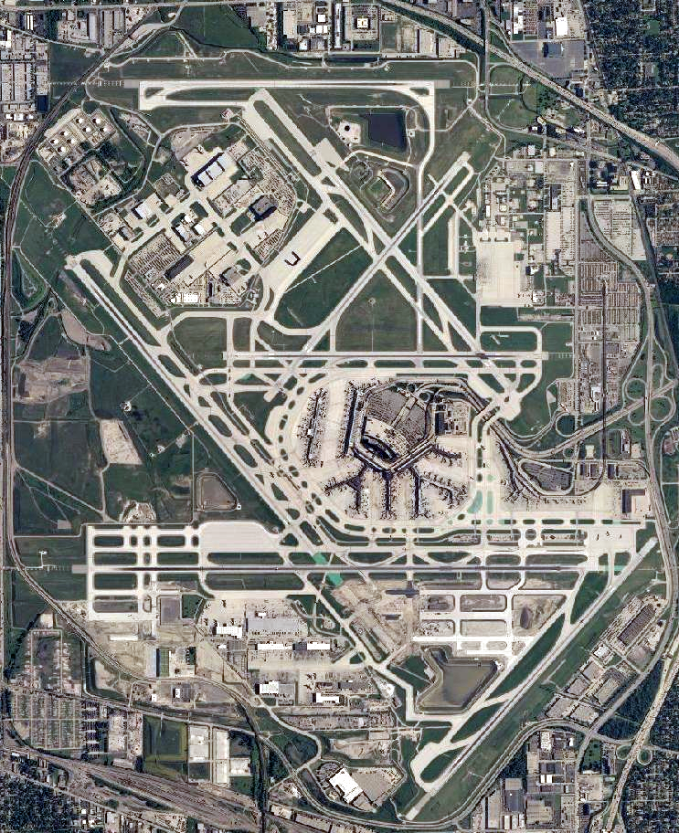
English: Satellite image of Chicago O'Hare International Airport |
|||
| تریخ | ||||
| سروت | USGS National Map Viewer | |||
| لکھاری |
|
فائل دی تریخ
فائل نو اس ویلے دی حالت وچ ویکھن واسطے تاریخ/ویلے تے کلک کرو۔
| تریخ تے ویلہ | نکی مورت | پاسے | ورتن والا | تیپّݨی کرو | |
|---|---|---|---|---|---|
| موجودہ | ۰۰:۵۱, ۳۰ نومبر ۲۰۱۱ | | ۷۴۳ × ۹۱۲ (۱.۵۶ میگابائٹ) | Nathan Johnson | color levels |
| ۱۵:۴۱, ۱۳ اکتوبر ۲۰۱۱ |  | ۷۴۳ × ۹۱۲ (۱.۴۶ میگابائٹ) | Nickvet419 | ({{Information| |Description= |Source=USGS National Map Viewer |Date=October 13, 2011|Author={{PD-USGov-USGS}} |Permission= |other_versions= }} ) | |
| ۰۵:۰۸, ۱۷ جون ۲۰۰۷ |  | ۱,۱۳۲ × ۱,۱۳۲ (۲.۱۴ میگابائٹ) | Brianski | File sized slightly reduced via optipng -o7 | |
| ۱۴:۲۴, ۱۴ مئی ۲۰۰۶ |  | ۱,۱۳۲ × ۱,۱۳۲ (۲.۱۸ میگابائٹ) | Wangi | zoom in a bit | |
| ۲۳:۴۴, ۲۷ مارچ ۲۰۰۶ |  | ۱,۶۸۰ × ۱,۰۵۰ (۳.۰۸ میگابائٹ) | Keeleysam | {{Information| |Description= |Source=NASA World Wind Screenshot |Date= |Author={{PD-USGov-USGS}} |Permission= |other_versions= }} |
فائل دی ورتوں
تھلے دتے گئے 1 صفحے اس فائل نال جُڑدے نیں
فائل ویاپک ورتوں
ایہہ دوجے وکیاں ایس فائل نوں ورتدے نیں –
- af.wikipedia.org تے ورتوں
- ar.wikipedia.org تے ورتوں
- arz.wikipedia.org تے ورتوں
- ast.wikipedia.org تے ورتوں
- bg.wikipedia.org تے ورتوں
- ckb.wikipedia.org تے ورتوں
- cs.wikipedia.org تے ورتوں
- da.wikipedia.org تے ورتوں
- de.wikipedia.org تے ورتوں
- de.wikivoyage.org تے ورتوں
- en.wikivoyage.org تے ورتوں
- eu.wikipedia.org تے ورتوں
- fa.wikipedia.org تے ورتوں
- fi.wikipedia.org تے ورتوں
- fr.wikipedia.org تے ورتوں
- fr.wikivoyage.org تے ورتوں
- fy.wikipedia.org تے ورتوں
- gl.wikipedia.org تے ورتوں
- he.wikipedia.org تے ورتوں
- he.wikivoyage.org تے ورتوں
- hu.wikipedia.org تے ورتوں
- id.wikipedia.org تے ورتوں
- it.wikipedia.org تے ورتوں
- ja.wikipedia.org تے ورتوں
- ko.wikipedia.org تے ورتوں
- lv.wikipedia.org تے ورتوں
- ml.wikipedia.org تے ورتوں
- mr.wikipedia.org تے ورتوں
- nl.wikipedia.org تے ورتوں
- no.wikipedia.org تے ورتوں
- oc.wikipedia.org تے ورتوں
- pl.wikipedia.org تے ورتوں
- pt.wikipedia.org تے ورتوں
- ro.wikipedia.org تے ورتوں
- ru.wikipedia.org تے ورتوں
- sl.wikipedia.org تے ورتوں
- sv.wikipedia.org تے ورتوں
- ta.wikipedia.org تے ورتوں
- th.wikipedia.org تے ورتوں
- tr.wikipedia.org تے ورتوں
- tt.wikipedia.org تے ورتوں
- uk.wikipedia.org تے ورتوں
ایس فائل دا ویکھو ہور جگت ورتن .
.png)
.png)