
فائل:Occupation of Poland 1939.png
ایس وکھالے دا ناپ: ۴۴۳ × ۵۹۹ پکسلز۔ دوجے ریزولوشنز: ۱۷۷ × ۲۴۰ پکسلز | ۳۵۵ × ۴۸۰ پکسلز | ۵۶۸ × ۷۶۸ پکسلز | ۷۵۷ × ۱,۰۲۴ پکسلز | ۲,۴۷۹ × ۳,۳۵۴ پکسلز ۔
اصل فائل (۲,۴۷۹ × ۳,۳۵۴ پکسلز, فائل حجم: ۸۴۹ کلوبائٹ, MIME type: image/png)

|
This map image could be re-created using vector graphics as an SVG file. This has several advantages; see Commons:Media for cleanup for more information. If an SVG form of this image is available, please upload it and afterwards replace this template with
{{vector version available|new image name}}.
It is recommended to name the SVG file “Occupation of Poland 1939.svg”—then the template Vector version available (or Vva) does not need the new image name parameter. |
خلاصہ
| تفصیل |
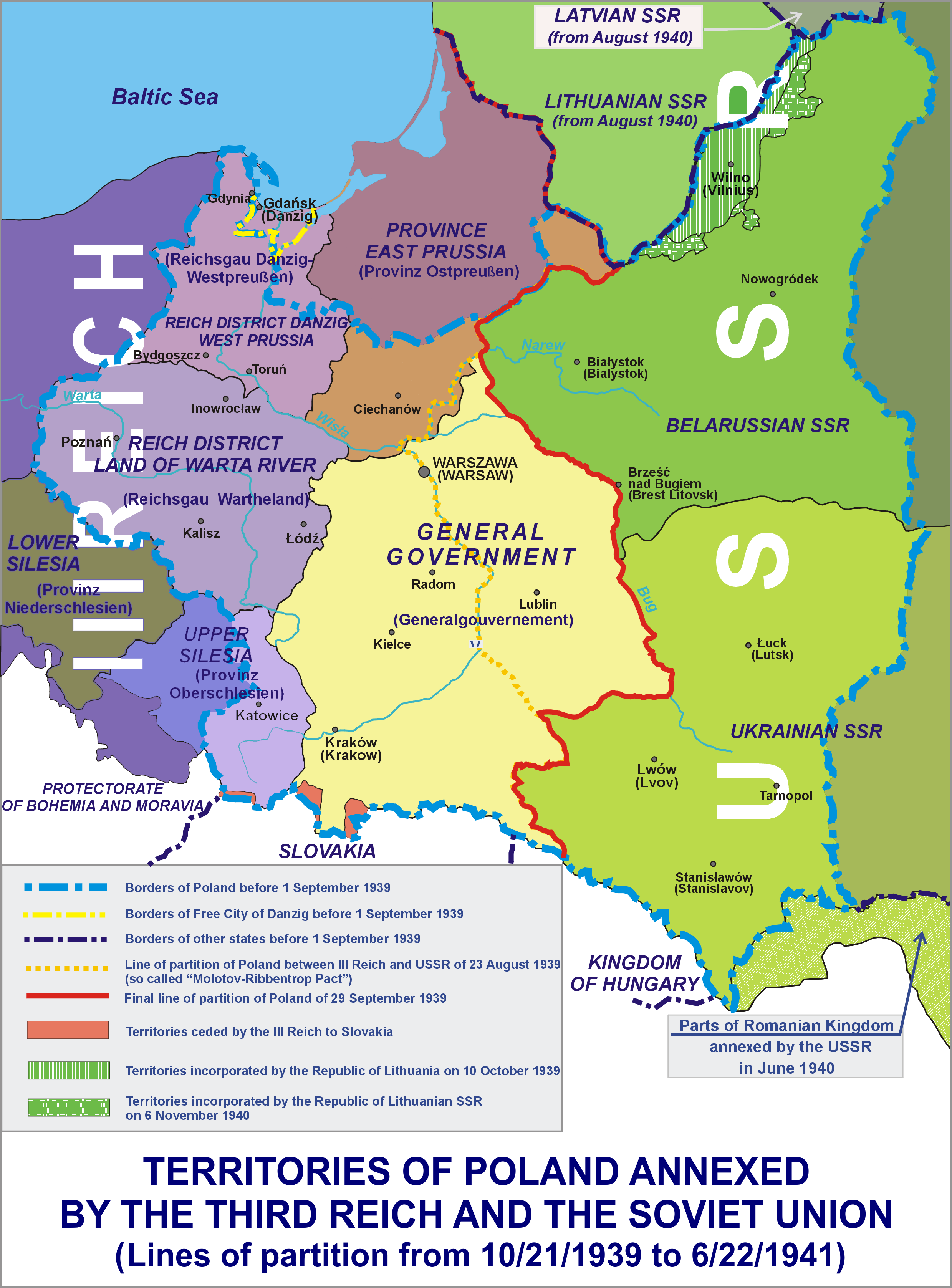
English: Poland occupied by Nazi Germany (Third Reich) and the USSR (21/10/1939-22/06/1941) |
| تریخ | |
| سروت | آپݨا کم |
| لکھاری | Lonio17 |
| دوجے ورژن |
[]
|

.png)


لائسنس –
میں، اس کم دے کاپیرائٹ دا مالک، اس کم نوں اس لائسنس دے مطابق چھاپدا واں:

|
کاپی کرن، ونڈن تے بدلن دی ایس ڈوکومنٹ لئی اجازت دتی جاندی اے ایہناں GNU Free Documentation License, Version 1.2 شرطاں نال یا مگروں کسے وی چھپے ورین Free Software Foundation توں بنا کسے انویرینٹ سیکشن دے، ناں فرنٹ کور لکھت تے ناں بیک کور لکھت دے۔ لسنس دی اک کاپی سیکشن وچ ہیگی اے جہدا ناں اے GNU Free Documentation License۔ |
This file is licensed under the Creative Commons Attribution-Share Alike 4.0 International, 3.0 Unported, 2.5 Generic, 2.0 Generic and 1.0 Generic license.
- تہانوں کھلھ اے:
- حصہ کرنا – کاپی، ونڈنا تے کم بھیجنا
- فیر رلانا – کم نوں فٹ کرنا
- تھلے دتیاں شرطاں نال:
- کس دے ناں – تسیں لازمی ایس کم دے بناں والے بارے دسو جنج اونے آکھیا اے یا جنج لسنس چ آکھیا گیا ہے۔
- اکو جہا شئیر کرو۔ – اگر تسیں بدلدے یا ایس کم تے بناندے تے بنن والے کم نوں اینج دے لسنس نال ای ونڈو گے۔
تسیں اپنی مرضی دا لائسنس چݨ سکدے اوہ۔
فائل دی تریخ
فائل نو اس ویلے دی حالت وچ ویکھن واسطے تاریخ/ویلے تے کلک کرو۔
| تریخ تے ویلہ | نکی مورت | پاسے | ورتن والا | تیپّݨی کرو | |
|---|---|---|---|---|---|
| موجودہ | ۰۲:۲۷, ۲۶ جنوری ۲۰۱۸ | | ۲,۴۷۹ × ۳,۳۵۴ (۸۴۹ کلوبائٹ) | Maproom | Move open-left-parenthesis closer to following text, in bottom line. Correct spelling, "annected" to "annexed". |
| ۰۶:۰۱, ۱۱ ستمبر ۲۰۱۷ |  | ۲,۴۷۹ × ۳,۳۵۴ (۱,۰۰۲ کلوبائٹ) | Poeticbent | please don't use crazy colours, I want to use these maps for serious articles | |
| ۱۳:۵۷, ۲۳ اپریل ۲۰۱۷ |  | ۲,۴۸۳ × ۳,۳۵۹ (۱.۲۶ میگابائٹ) | Lonio17 | Reverted to version as of 08:38, 23 April 2017 (UTC) | |
| ۱۳:۴۲, ۲۳ اپریل ۲۰۱۷ |  | ۲,۴۸۱ × ۳,۳۵۵ (۸۴۶ کلوبائٹ) | Lonio17 | Reverted to version as of 03:18, 19 July 2016 (UTC) | |
| ۱۳:۳۸, ۲۳ اپریل ۲۰۱۷ |  | ۲,۴۸۳ × ۳,۳۵۹ (۱.۲۶ میگابائٹ) | Lonio17 | Poprawiono błąd w tłumaczeniu (annexed) | |
| ۰۸:۱۸, ۱۹ جولائی ۲۰۱۶ |  | ۲,۴۸۱ × ۳,۳۵۵ (۸۴۶ کلوبائٹ) | Poeticbent | color coordination for people with vision impairment per talk in English Wikipedia | |
| ۱۹:۳۴, ۲۴ نومبر ۲۰۱۵ |  | ۲,۴۸۲ × ۳,۳۷۲ (۸۵۸ کلوبائٹ) | Poeticbent | marked the difference in hue between the old and new border divisions following the invasion | |
| ۲۰:۰۵, ۲۹ مارچ ۲۰۱۴ |  | ۲,۴۸۲ × ۳,۳۷۲ (۸۰۱ کلوبائٹ) | Lonio17 | small correction | |
| ۱۴:۰۱, ۲۹ مارچ ۲۰۱۴ |  | ۲,۴۸۲ × ۳,۳۷۲ (۸۰۶ کلوبائٹ) | Lonio17 | {{Information |Description={{en|1=Poland occupied by Nazi Germany (Third Reich) and the USSR (21/10/1939-22/06/1941)}} |Source={{own}} |Author=Lonio17 |Date=2014-03-29 |Permission= |other_versions= }} =={{int:license}}== {{self|GFDL|c... |
فائل دی ورتوں
تھلے دتے گئے 1 صفحے اس فائل نال جُڑدے نیں
فائل ویاپک ورتوں
ایہہ دوجے وکیاں ایس فائل نوں ورتدے نیں –
- ar.wikipedia.org تے ورتوں
- az.wikipedia.org تے ورتوں
- cs.wikipedia.org تے ورتوں
- de.wikipedia.org تے ورتوں
- el.wikipedia.org تے ورتوں
- en.wikipedia.org تے ورتوں
- Partitions of Poland
- History of Poland (1939–1945)
- Polish areas annexed by Nazi Germany
- German-occupied Poland
- Territorial evolution of Poland
- Polish culture during World War II
- Subdivisions of Polish territories during World War II
- Military enrolment in German-occupied Poland
- User:Kazkaskazkasako/Books/History
- Occupation of Poland (1939–1945)
- Collaboration in German-occupied Poland
- User:Falcaorib
- et.wikipedia.org تے ورتوں
- fr.wikipedia.org تے ورتوں
- he.wikipedia.org تے ورتوں
- hy.wikipedia.org تے ورتوں
- id.wikipedia.org تے ورتوں
- it.wikipedia.org تے ورتوں
- ja.wikipedia.org تے ورتوں
- lv.wikipedia.org تے ورتوں
- ms.wikipedia.org تے ورتوں
- nl.wikipedia.org تے ورتوں
- no.wikipedia.org تے ورتوں
- pl.wikipedia.org تے ورتوں
- pt.wikipedia.org تے ورتوں
- ro.wikipedia.org تے ورتوں
- ru.wikipedia.org تے ورتوں
- si.wikipedia.org تے ورتوں
- sq.wikipedia.org تے ورتوں
ایس فائل دا ویکھو ہور جگت ورتن .