
فائل:Oceanias Regions.png
اس توں وڈی مورت موجود نہیں۔
Oceanias_Regions.png (۵۵۲ × ۳۵۰ پکسلز, فائل حجم: ۲۰ کلوبائٹ, MIME type: image/png)

|
This locator map image could be re-created using vector graphics as an SVG file. This has several advantages; see Commons:Media for cleanup for more information. If an SVG form of this image is available, please upload it and afterwards replace this template with
{{vector version available|new image name}}.
It is recommended to name the SVG file “Oceanias Regions.svg”—then the template Vector version available (or Vva) does not need the new image name parameter. |
| تفصیل |
Català: Regions d'Oceania.
Čeština: Regiony Oceánie.
Deutsch: Regionen Ozeaniens.
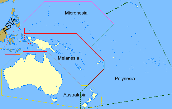
English: Regions of Oceania. Regions of Oceania: In its narrow usage Oceania refers to Polynesia (including New Zealand), Melanesia (including New Guinea) and Micronesia. In wider usage it includes Australia. It may also include the Malay archipelago. In uncommon usage it includes islands such as Japan and the Aleutian Islands.
Limburgs: Regio's van Oceanië.
Русский: Регионы Океании.
Саха тыла: Океания регионнара.
Svenska: Oceaniens regioner.
తెలుగు: ఓషియానియా ప్రాంతాలు.
Tiếng Việt: Các khu vực của châu Đại Dương. |
| تریخ | ۱۷ فروری ۲۰۰۸ (original upload date) |
| سروت | Transferred from en.wikipedia to Commons by Grillo using CommonsHelper. |
| لکھاری | ASDFGH at English وکیپیڈیا |
لائسنس –
| اس کم نوں لوکاں لئی ایدے لکھاریASDFGH at English وکیپیڈیا نے دے دتا اے، اے سارے جگ واسطے لاگو اے۔ کج ملکاں چ قانونی طور تے اے ممکن نئیں اے؛ اگر انج ای اے ے: ASDFGH ہر کسے نوں اس کم نوں کسے وی مقصد واسطے ورتن دا بغیر کسے شرط دے حق دیندا واں، اگر اوہ قانون دے خلاف نا ہوۓ۔ |
پہلا اپلوڈ دا ریکارڈ
The original description page was here. All following user names refer to en.wikipedia.
- 2008-02-17 00:28 ASDFGH 552×350× (17433 bytes)
فائل دی تریخ
فائل نو اس ویلے دی حالت وچ ویکھن واسطے تاریخ/ویلے تے کلک کرو۔
| تریخ تے ویلہ | نکی مورت | پاسے | ورتن والا | تیپّݨی کرو | |
|---|---|---|---|---|---|
| موجودہ | ۱۸:۲۰, ۱۸ ستمبر ۲۰۱۱ | | ۵۵۲ × ۳۵۰ (۲۰ کلوبائٹ) | Maphobbyist | Map depicting continents according to plate tectonics. The Eastern Sunda Islands and the Moluccas are also part of the Asian tectonic plate. |
| ۲۱:۵۷, ۳۰ اکتوبر ۲۰۰۸ |  | ۵۵۲ × ۳۵۰ (۱۷ کلوبائٹ) | File Upload Bot (Magnus Manske) | {{BotMoveToCommons|en.wikipedia}} {{Information |Description={{en|''no original description''}} |Source=Transferred from [http://en.wikipedia.org en.wikipedia]; transferred to Commons by User:Grillo using [http://tools.wikimedia.de/~magnus/commonshel |
فائل دی ورتوں
تھلے دتے گئے 1 صفحے اس فائل نال جُڑدے نیں
فائل ویاپک ورتوں
ایہہ دوجے وکیاں ایس فائل نوں ورتدے نیں –
- ast.wiktionary.org تے ورتوں
- bn.wikipedia.org تے ورتوں
- ca.wikipedia.org تے ورتوں
- co.wikipedia.org تے ورتوں
- cs.wikipedia.org تے ورتوں
- cy.wiktionary.org تے ورتوں
- da.wiktionary.org تے ورتوں
- el.wiktionary.org تے ورتوں
- en.wikipedia.org تے ورتوں
- en.wiktionary.org تے ورتوں
- fa.wikipedia.org تے ورتوں
- fo.wikipedia.org تے ورتوں
- fr.wikipedia.org تے ورتوں
- gl.wikipedia.org تے ورتوں
- hi.wikipedia.org تے ورتوں
- ilo.wikipedia.org تے ورتوں
- incubator.wikimedia.org تے ورتوں
- ja.wikipedia.org تے ورتوں
- kk.wikipedia.org تے ورتوں
- ko.wikipedia.org تے ورتوں
- la.wikipedia.org تے ورتوں
- li.wikipedia.org تے ورتوں
- lld.wikipedia.org تے ورتوں
- lt.wikipedia.org تے ورتوں
- mg.wikipedia.org تے ورتوں
- my.wikipedia.org تے ورتوں
- pa.wikipedia.org تے ورتوں
- ro.wikipedia.org تے ورتوں
- sah.wikipedia.org تے ورتوں
- si.wiktionary.org تے ورتوں
- sk.wikipedia.org تے ورتوں
- sv.wikipedia.org تے ورتوں
- ta.wikipedia.org تے ورتوں
- te.wikipedia.org تے ورتوں
- th.wikipedia.org تے ورتوں
- tr.wikipedia.org تے ورتوں
- uk.wikipedia.org تے ورتوں
- yo.wikipedia.org تے ورتوں