
فائل:Parthia 001ad.jpg
اصل فائل (۷۹۳ × ۶۵۲ پکسلز, فائل حجم: ۷۴۱ کلوبائٹ, MIME type: image/jpeg)

|
This historical map image could be re-created using vector graphics as an SVG file. This has several advantages; see Commons:Media for cleanup for more information. If an SVG form of this image is available, please upload it and afterwards replace this template with
{{vector version available|new image name}}.
It is recommended to name the SVG file “Parthia 001ad.svg”—then the template Vector version available (or Vva) does not need the new image name parameter. |


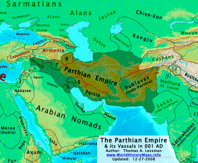
| تفصیل | The Parthian Empire in 001 AD. |
| تریخ | |
| سروت | آپݨا کم; derived from (1) John Nelson. Interactive Historical Atlas of the World. Map of "Countries of the World 1/1/001 CE" and (2) Encyclopaedia Iranica, their article about the Parthians. |
| لکھاری | Thomas Lessman (Contact!) |
| اجازت (فائل نوں دوبارہ ورتنا) |
ایس فائل نوں کریٹو کامنز Attribution 3.0 انپورٹڈ لائسنس دتا گیا.
|
| دوجے ورژن | see below, العربيَّة |
Map Summary

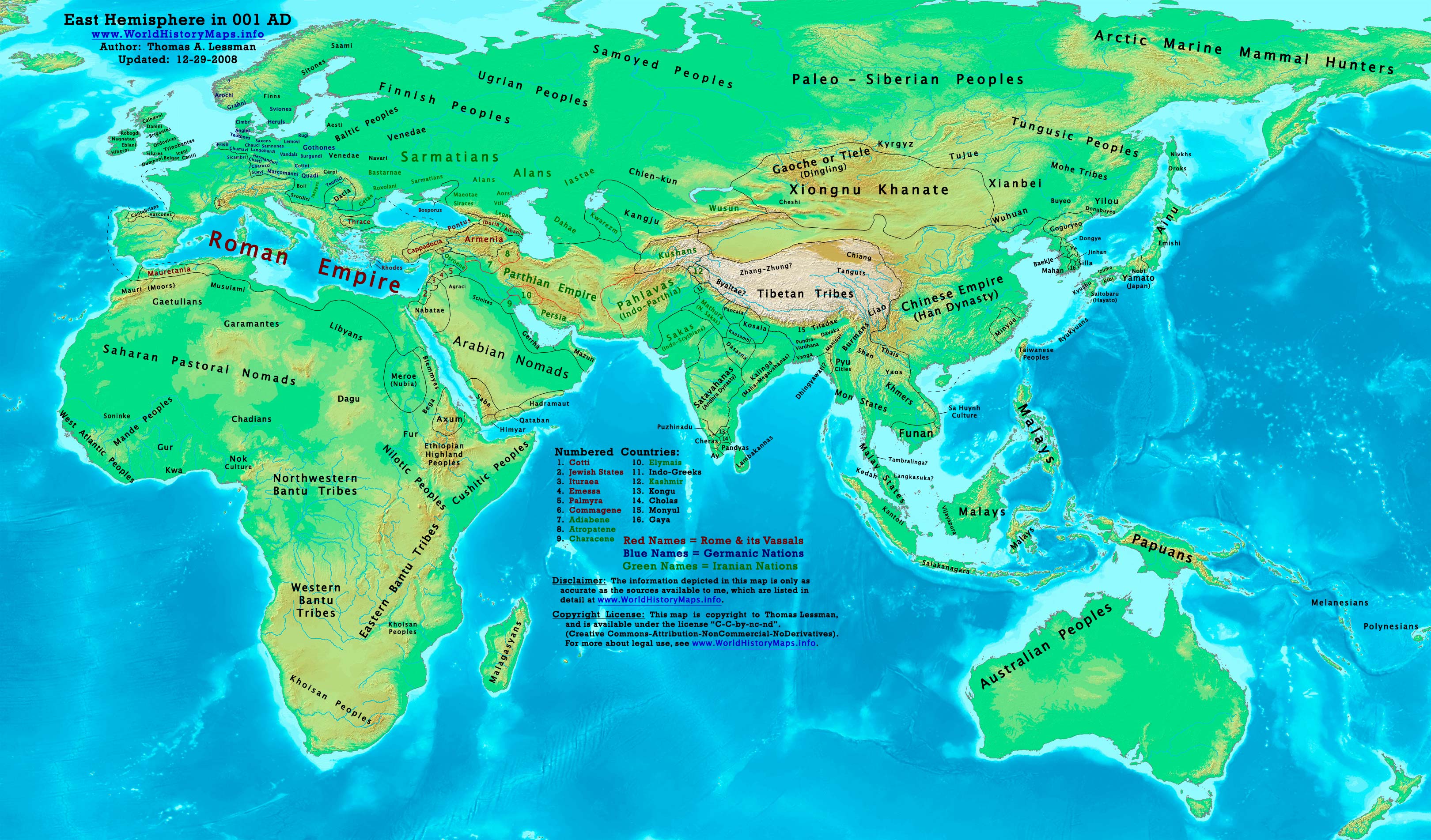
Original Source URL: http://www.worldhistorymaps.info/images/East-Hem_001ad.jpg
This map is a zoomed-in version of Thomas Lessman's map of the
East-Hem_001ad.jpg (also available at www.WorldHistoryMaps.info).
The highlighted areas represent the Parthian Empire and its vassal kingdoms in the year 1 AD.
Map Source References
Remember, sources often conflict with each other. This map is only as accurate as the information that is available to me. To report any errors or to help further this work, please click here, or email Thomas Lessman at talessman@yis.us
References for information contained in this map:
Other Maps by Thomas Lessman
| Maps of the eastern hemisphere showing history
Bold dates are available on Wikimedia or Wikipedia. | ||
| Primeval | ||
| Ancient
|
·| 600 BC | 550 BC | 527 BC | 500 BC |
400 BC | ·| 1 AD | 50 AD | 100 AD | 200 AD | 300 AD | | |
| Medieval |
·| 500 AD | 565 AD | 600 AD | 700 AD | | |
| Modern |
·| 1500 AD | · * For historical maps of the whole world, | |
Other Info
فائل دی تریخ
فائل نو اس ویلے دی حالت وچ ویکھن واسطے تاریخ/ویلے تے کلک کرو۔
| تریخ تے ویلہ | نکی مورت | پاسے | ورتن والا | تیپّݨی کرو | |
|---|---|---|---|---|---|
| موجودہ | ۰۷:۰۹, ۲۹ دسمبر ۲۰۰۸ | | ۷۹۳ × ۶۵۲ (۷۴۱ کلوبائٹ) | Talessman | Category:Maps of the history of Iran |
| ۰۲:۳۷, ۱۷ مئی ۲۰۰۸ |  | ۱,۰۲۵ × ۶۷۷ (۷۷۱ کلوبائٹ) | Talessman | Improved border appearance, corrected eastern borders of Parthia, other corrections explained on the [http://commons.wikimedia.org/wiki/Image:East-Hem_001ad.jpg East-Hem_001ad.jpg] description page. | |
| ۰۳:۵۱, ۱۰ مئی ۲۰۰۸ |  | ۱,۰۲۲ × ۸۵۴ (۲۸۶ کلوبائٹ) | Talessman | {{Information |Description='''<big>The [http://en.wikipedia.org/wiki/Parthian_Empire Parthian Empire] in 001 AD.'''</big> |Source=Self-made |Author=Thomas Lessman (Contact!) |Permission={{self|cc-by-sa-3.0}} }} |
فائل دی ورتوں
تھلے دتے گئے 1 صفحے اس فائل نال جُڑدے نیں
فائل ویاپک ورتوں
ایہہ دوجے وکیاں ایس فائل نوں ورتدے نیں –
- af.wikipedia.org تے ورتوں
- an.wikipedia.org تے ورتوں
- ar.wikipedia.org تے ورتوں
- av.wikipedia.org تے ورتوں
- azb.wikipedia.org تے ورتوں
- az.wikipedia.org تے ورتوں
- ba.wikipedia.org تے ورتوں
- be.wikipedia.org تے ورتوں
- bg.wikipedia.org تے ورتوں
- ca.wikipedia.org تے ورتوں
- ceb.wikipedia.org تے ورتوں
- ckb.wikipedia.org تے ورتوں
- cs.wikipedia.org تے ورتوں
- da.wikipedia.org تے ورتوں
- de.wikipedia.org تے ورتوں
- el.wikipedia.org تے ورتوں
- en.wikipedia.org تے ورتوں
- es.wikipedia.org تے ورتوں
- fa.wikipedia.org تے ورتوں
- fr.wikipedia.org تے ورتوں
ایس فائل دا ویکھو ہور جگت ورتن .