
فائل:PeriplusAncientMap.jpg
ایس وکھالے دا ناپ: ۷۶۳ × ۶۰۰ پکسلز۔ دوجے ریزولوشنز: ۳۰۵ × ۲۴۰ پکسلز | ۶۱۱ × ۴۸۰ پکسلز | ۹۷۷ × ۷۶۸ پکسلز | ۱,۲۸۰ × ۱,۰۰۶ پکسلز | ۱,۵۲۴ × ۱,۱۹۸ پکسلز ۔
اصل فائل (۱,۵۲۴ × ۱,۱۹۸ پکسلز, فائل حجم: ۲۳۹ کلوبائٹ, MIME type: image/jpeg)
خلاصہ
| تفصیل |
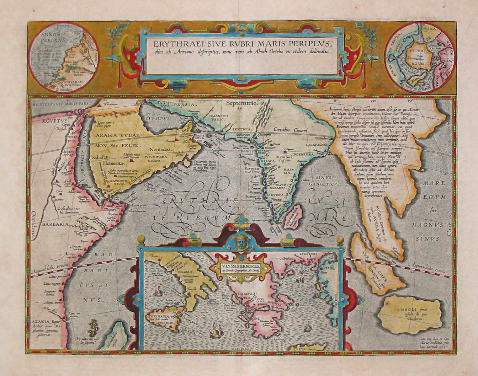
English: Map by Abraham Ortelius, (1527-1598) for the Periplus Maris Erythraei (Περίπλους τὴς Ἐρυθράς Θαλάσσης "Periplus of the Erythraean Sea"), attributed to Arrian. |
|||||||||||||||||||||||
| تریخ | ||||||||||||||||||||||||
| سروت | Plate [162] from: Theatrum orbus terrarum / Abraham Ortelius. Antverpiae: Apud Ioannem Bapt. Vrintium, 1609. | |||||||||||||||||||||||
| لکھاری |
|
|||||||||||||||||||||||

See also:
لائسنس –
|
This is a faithful photographic reproduction of a two-dimensional, public domain work of art. The work of art itself is in the public domain for the following reason:
The official position taken by the Wikimedia Foundation is that "faithful reproductions of two-dimensional public domain works of art are public domain".
This photographic reproduction is therefore also considered to be in the public domain in the United States. In other jurisdictions, re-use of this content may be restricted; see Reuse of PD-Art photographs for details. | ||||
فائل دی تریخ
فائل نو اس ویلے دی حالت وچ ویکھن واسطے تاریخ/ویلے تے کلک کرو۔
| تریخ تے ویلہ | نکی مورت | پاسے | ورتن والا | تیپّݨی کرو | |
|---|---|---|---|---|---|
| موجودہ | ۱۳:۱۰, ۲۴ مارچ ۲۰۰۷ | | ۱,۵۲۴ × ۱,۱۹۸ (۲۳۹ کلوبائٹ) | World Imaging | Ancient map (17th century) depicting the locations of the Periplus of the Erythraean Sea. |
فائل دی ورتوں
تھلے دتے گئے 1 صفحے اس فائل نال جُڑدے نیں
فائل ویاپک ورتوں
ایہہ دوجے وکیاں ایس فائل نوں ورتدے نیں –
- ar.wikipedia.org تے ورتوں
- as.wikipedia.org تے ورتوں
- bn.wikipedia.org تے ورتوں
- br.wikipedia.org تے ورتوں
- ca.wikipedia.org تے ورتوں
- cs.wikipedia.org تے ورتوں
- de.wikipedia.org تے ورتوں
- el.wikipedia.org تے ورتوں
- en.wikipedia.org تے ورتوں
- es.wikipedia.org تے ورتوں
- fa.wikipedia.org تے ورتوں
- fa.wikibooks.org تے ورتوں
- fr.wikipedia.org تے ورتوں
- he.wikipedia.org تے ورتوں
- hif.wikipedia.org تے ورتوں
- hi.wikipedia.org تے ورتوں
- hr.wikipedia.org تے ورتوں
- hu.wikipedia.org تے ورتوں
- ilo.wikipedia.org تے ورتوں
- it.wikipedia.org تے ورتوں
- ja.wikipedia.org تے ورتوں
- la.wikipedia.org تے ورتوں
- no.wikipedia.org تے ورتوں
- oc.wikipedia.org تے ورتوں
- or.wikipedia.org تے ورتوں
- ru.wikipedia.org تے ورتوں
- sd.wikipedia.org تے ورتوں
- sh.wikipedia.org تے ورتوں
- simple.wikipedia.org تے ورتوں
- sl.wikipedia.org تے ورتوں
ایس فائل دا ویکھو ہور جگت ورتن .