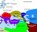
فائل:Pontic steppe region around 650 AD.png

Page contents not supported in other languages.
آزاد انسائیکلوپیڈیا، وکیپیڈیا توں

Pontic_steppe_region_around_650_AD.png(۶۳۷ × ۵۵۳ پکسلز, فائل حجم: ۴۰ کلوبائٹ, MIME type: image/png)

ایہ فائل Wikimedia Commons توں اے تے دوجیاں ویونتاں تے وی ورتی جاسکدی اے۔ گل بات اس دے فائل گل بات صفحہ تے تھلے دتی گئی۔

خلاصہ

This historical map image could be re-created using vector graphics as an SVG file. This has several advantages; see Commons:Media for cleanup for more information. If an SVG form of this image is available, please upload it and afterwards replace this template with {{vector version available|new image name}}.


It is recommended to name the SVG file “Pontic steppe region around 650 AD.svg”—then the template Vector version available (or Vva) does not need the new image name parameter.
Description
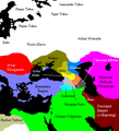
English: The en:Pontic steppe region, c. 650 CE.
Русский: Черноморско-каспийский регион около 650 года н.э.
Deutsch: Die Verteilung von Stämmen und Herrschaften in der Pontokaspischen Region um 650 n. Chr.
Français : Carte de la steppe pontique aux environs de l'an 650.
تریخ ۲۹ دسمبر ۲۰۰۵ (original upload date)
سروت Transferred from en.wikipedia to Commons.
Creator
The original uploader was Briangotts at English وکیپیڈیا.
 Geotemporal data
Bounding box
N: 64.190751°N
W: 13.879759°E E: 72.5553846°E
S: 27.6329482°N
Georeferencing View the georeferenced map in the Wikimaps Warper

لائسنس –

GNU head کاپی کرن، ونڈن تے بدلن دی ایس ڈوکومنٹ ل‏ئی اجازت دتی جاندی اے ایہناں GNU Free Documentation License, Version 1.2 شرطاں نال یا مگروں کسے وی چھپے ورین Free Software Foundation توں بنا کسے انویرینٹ سیکشن دے، ناں فرنٹ کور لکھت تے ناں بیک کور لکھت دے۔ لسنس دی اک کاپی سیکشن وچ ہیگی اے جہدا ناں اے GNU Free Documentation License۔
w:en:Creative Commons
کس دے ناں اکو جہا شئیر کرو۔
ایس فائل نوں کریٹو کامنز Attribution 2.5 پولینڈ لائسنس دتا گیا.
تہانوں کھلھ اے:
  • حصہ کرنا – کاپی، ونڈنا تے کم بھیجنا
  • فیر رلانا – کم نوں فٹ کرنا
تھلے دتیاں شرطاں نال:
  • کس دے ناں – تسیں لازمی ایس کم دے بناں والے بارے دسو جنج اونے آکھیا اے یا جنج لسنس چ آکھیا گیا ہے۔
  • اکو جہا شئیر کرو۔ – اگر تسیں بدلدے یا ایس کم تے بناندے تے بنن والے کم نوں اینج دے لسنس نال ای ونڈو گے۔
اس لائسنس دا ٹیگ GFDL دے مطابق اس فائل چ پایا گیا اے licensing update۔

پہلا اپلوڈ دا ریکارڈ

The original description page was here. All following user names refer to en.wikipedia.
  • 2007-04-11 19:01 Briangotts 637×553×8 (27154 bytes) == Summary == The [[Pontic steppe]] region, c. AD 650. [[Category:Historical maps by User:Briangotts]] [[Category:Maps of the history of Russia]]
  • 2006-01-24 17:57 Briangotts 406×448×8 (15464 bytes) == Summary == The [[Pontic steppe]] region, c. 650 CE. [[Category:Historical maps by User:Briangotts]] == Licensing == {{GFDL-self}}
  • 2005-12-29 20:33 Briangotts 406×448×8 (15489 bytes) == Summary == The [[Pontic steppe]] region, c. 650 CE. [[Category:Historical maps by User:Briangotts]] == Licensing == {{GFDL-self}}
  • 2005-12-29 20:30 Briangotts 406×448×8 (15662 bytes) The [[Pontic steppe]] region, c. 650 CE. [[Category:Historical maps by User:Briangotts]]

Captions

Add a one-line explanation of what this file represents

Items portrayed in this file

چترن

copyrighted English

MIME type English

image/png

فائل دی تریخ

فائل نو اس ویلے دی حالت وچ ویکھن واسطے تاریخ/ویلے تے کلک کرو۔

تریخ تے ویلہنکی مورتپاسےورتن والاتیپّݨی کرو
موجودہ۲۲:۳۵, ۱۴ اکتوبر ۲۰۲۲۲۲:۳۵, ۱۴ اکتوبر ۲۰۲۲ ویلے دے ورژن ساتھ انگوٹھاکار روپ۶۳۷ × ۵۵۳ (۴۰ کلوبائٹ)Gyalu22The Byzantine and Sassanian empires were under invasion
۰۱:۳۳, ۲۵ فروری ۲۰۱۶۰۱:۳۳, ۲۵ فروری ۲۰۱۶ ویلے دے ورژن ساتھ انگوٹھاکار روپ۶۳۷ × ۵۵۳ (۵۳ کلوبائٹ)Taron SaharyanАрмения был автономна, см. Theodore Rshtuni
۱۸:۳۵, ۲۳ دسمبر ۲۰۱۵۱۸:۳۵, ۲۳ دسمبر ۲۰۱۵ ویلے دے ورژن ساتھ انگوٹھاکار روپ۶۳۷ × ۵۵۳ (۵۱ کلوبائٹ)Ercwlfffor 650 armenia was already conquered by the arabs
۱۶:۰۸, ۲۵ ستمبر ۲۰۱۵۱۶:۰۸, ۲۵ ستمبر ۲۰۱۵ ویلے دے ورژن ساتھ انگوٹھاکار روپ۶۳۷ × ۵۵۳ (۵۳ کلوبائٹ)Taron Saharyanисправлены восточные пределы Армении
۱۶:۱۰, ۱۰ اگست ۲۰۱۴۱۶:۱۰, ۱۰ اگست ۲۰۱۴ ویلے دے ورژن ساتھ انگوٹھاکار روپ۶۳۷ × ۵۵۳ (۴۰ کلوبائٹ)Spiridon Ion CepleanuCosmetic little changes according with H.E.Stier (dir.) « Westermann Grosser Atlas zur Weltgeschichte », 1985, ISBN 3-14-100919-8, the « Putzger historischer Weltatlas Cornelsen » 1990, ISBN 3-464-00176-8, the André & Jean Sellier « Atlas des Peu...
۱۵:۴۳, ۲۵ مئی ۲۰۰۷۱۵:۴۳, ۲۵ مئی ۲۰۰۷ ویلے دے ورژن ساتھ انگوٹھاکار روپ۶۳۷ × ۵۵۳ (۲۷ کلوبائٹ)Angusmclellan{{Information |Description=The en:Pontic steppe region, c. AD 650. en:Category:Historical maps by User:Briangotts en:Category:Maps of the history of Russia |Source=Originally from [http://en.wikipedia.org en.wikipedia]; description page
۱۳:۴۴, ۱۷ جنوری ۲۰۰۶۱۳:۴۴, ۱۷ جنوری ۲۰۰۶ ویلے دے ورژن ساتھ انگوٹھاکار روپ۴۰۶ × ۴۴۸ (۱۵ کلوبائٹ)Jrohr== Summary == The Pontic steppe region, c. 650 CE. Category:Historical maps by User:Briangotts == Licensing == {{GFDL-self}}

تھلے دتے گئے 1 صفحے اس فائل نال جُڑدے نیں

فائل ویاپک ورتوں

ایہہ دوجے وکیاں ایس فائل نوں ورتدے نیں –

ایس فائل دا ویکھو ہور جگت ورتن .

میٹا ڈیٹا