
فائل:Reull Vallis lineated deposits.jpg
اس توں وڈی مورت موجود نہیں۔
Reull_Vallis_lineated_deposits.jpg (۶۲۰ × ۴۶۰ پکسلز, فائل حجم: ۵۱ کلوبائٹ, MIME type: image/jpeg)
خلاصہ
| تفصیل |
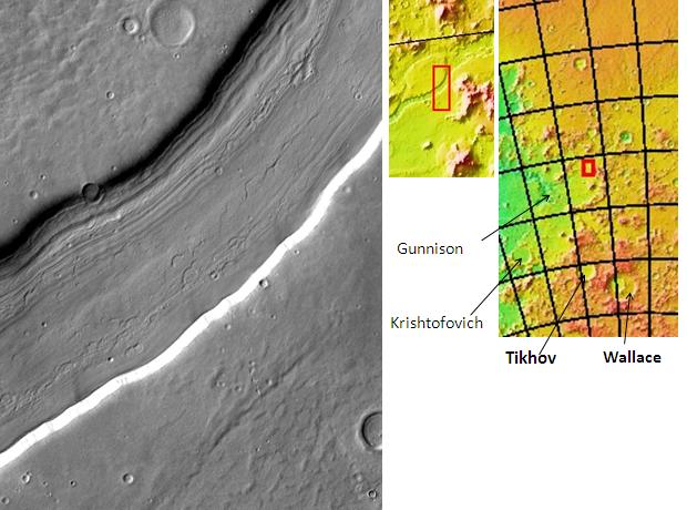
English: Reull Vallis lineated deposits, as seen by themis. Picture is located 41.1 degrees south latitude and 107.6 degrees east longitude. Picture is about 17 km wide. اردو : رول ویلس دھاری دار فرشی ذخیروں کے ساتھ۔ محل وقوع ہیلس چو گوشہ ہے۔ |
| تریخ | |
| سروت | http:themis.asu.edu/zoom-20021055a |
| لکھاری | Jim Secosky modified NASA image |
لائسنس –
| This file is in the public domain in the United States because it was solely created by NASA. NASA copyright policy states that "NASA material is not protected by copyright unless noted". (See Template:PD-USGov, NASA copyright policy page or JPL Image Use Policy.) | ||
 |
Warnings:
|
پہلا اپلوڈ دا ریکارڈ
The original description page was here. All following user names refer to en.wikipedia.
- 2009-02-23 16:09 Jimmarsmars 620×460× (52541 bytes) {{Information |Description=Reull Vallis lineated deposits, as seen by themis. Picture is located 41.1 degrees south latitude and 107.6 degrees east longitude. Picture is about 17 km wide. |Source=http:themis.asu.edu/zoom-20021055a |Date=February 23, 200

|
The categories of this image need checking. You can do so here.
|
فائل دی تریخ
فائل نو اس ویلے دی حالت وچ ویکھن واسطے تاریخ/ویلے تے کلک کرو۔
| تریخ تے ویلہ | نکی مورت | پاسے | ورتن والا | تیپّݨی کرو | |
|---|---|---|---|---|---|
| موجودہ | ۱۳:۱۶, ۱۹ اکتوبر ۲۰۱۵ | | ۶۲۰ × ۴۶۰ (۵۱ کلوبائٹ) | زہیر عبّاس | User created page with UploadWizard |
فائل دی ورتوں
تھلے دتے گئے 1 صفحے اس فائل نال جُڑدے نیں
فائل ویاپک ورتوں
ایہہ دوجے وکیاں ایس فائل نوں ورتدے نیں –
- ca.wikipedia.org تے ورتوں
- en.wikipedia.org تے ورتوں
- Vallis (planetary geology)
- Thermal Emission Imaging System
- Reull Vallis
- Hellas quadrangle
- Water on Mars
- Lobate debris apron
- Fretted terrain
- Lineated valley fill
- Chronology of discoveries of water on Mars
- Evidence of water on Mars from Mars Odyssey
- Common surface features of Mars
- User:Yildiztozu/sandbox
- es.wikipedia.org تے ورتوں
- ur.wikipedia.org تے ورتوں
- zh.wikipedia.org تے ورتوں