
فائل:STS040-610-50.jpg
ایس وکھالے دا ناپ: ۶۰۰ × ۶۰۰ پکسلز۔ دوجے ریزولوشنز: ۲۴۰ × ۲۴۰ پکسلز | ۴۸۰ × ۴۸۰ پکسلز | ۷۶۸ × ۷۶۸ پکسلز | ۱,۰۲۴ × ۱,۰۲۴ پکسلز | ۲,۰۴۸ × ۲,۰۴۸ پکسلز | ۵,۲۶۶ × ۵,۲۶۶ پکسلز ۔
اصل فائل (۵,۲۶۶ × ۵,۲۶۶ پکسلز, فائل حجم: ۶.۸ میگابائٹ, MIME type: image/jpeg)
خلاصہ
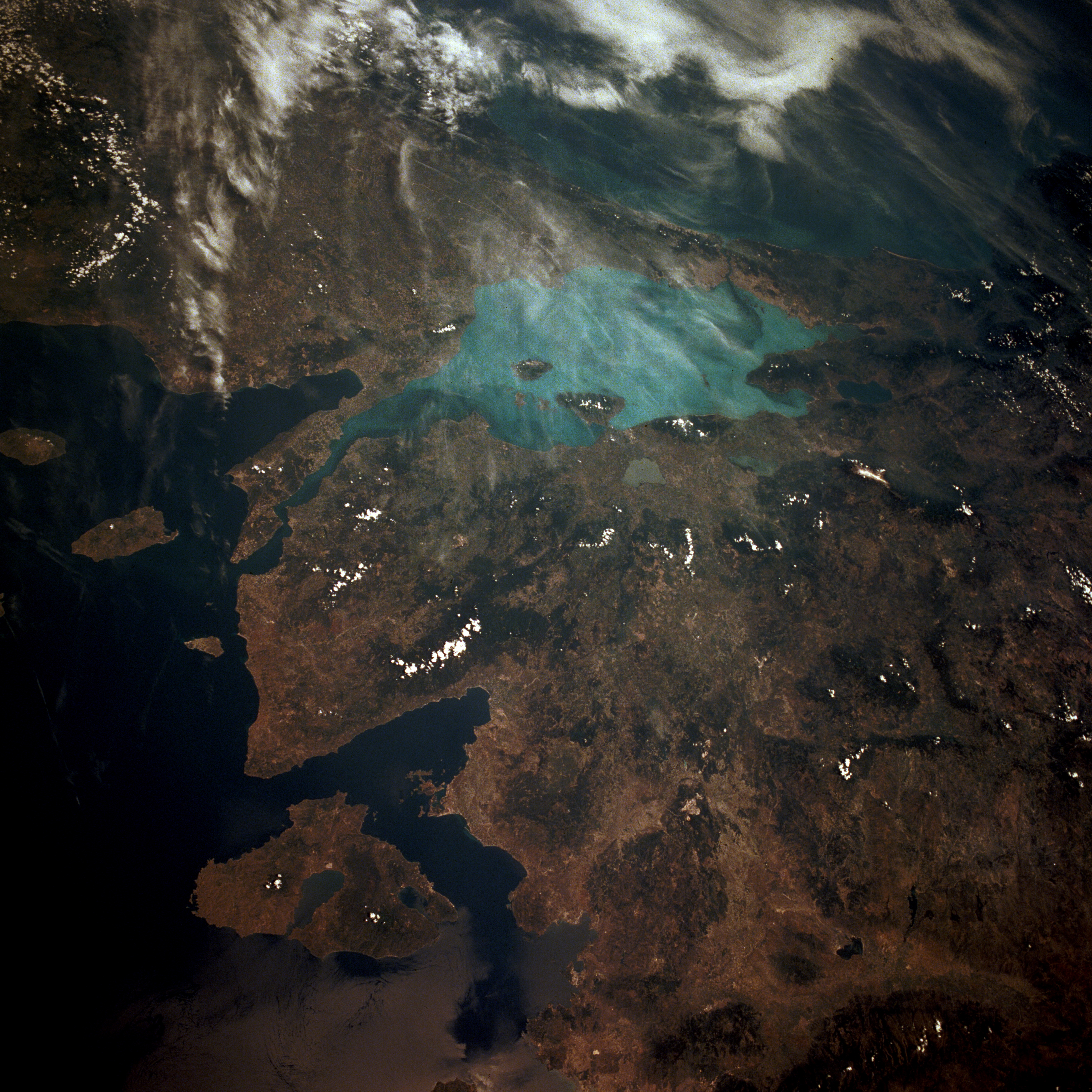
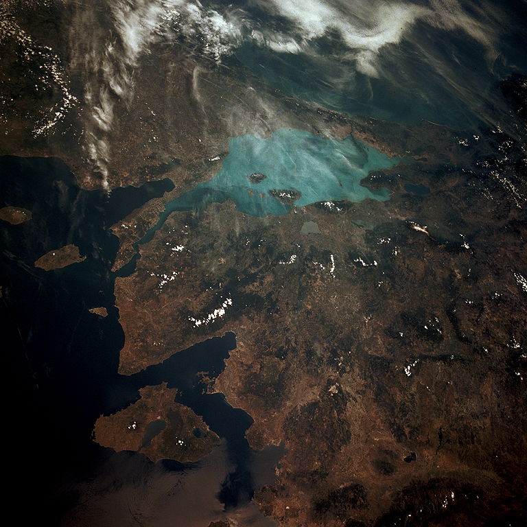
Español: Vista vía satélite del Mar de Marmara
Sea of Marmara in Turkey.
From STS 40, June 1991. NASA image information page
This image or video was catalogued by one of the centers of the United States National Aeronautics and Space Administration (NASA) under Photo ID: STS040-610-50. This tag does not indicate the copyright status of the attached work. A normal copyright tag is still required. See Commons:Licensing. Other languages:
|
| This file is in the public domain in the United States because it was solely created by NASA. NASA copyright policy states that "NASA material is not protected by copyright unless noted". (See Template:PD-USGov, NASA copyright policy page or JPL Image Use Policy.) | ||
 |
Warnings:
|
فائل دی تریخ
فائل نو اس ویلے دی حالت وچ ویکھن واسطے تاریخ/ویلے تے کلک کرو۔
| تریخ تے ویلہ | نکی مورت | پاسے | ورتن والا | تیپّݨی کرو | |
|---|---|---|---|---|---|
| موجودہ | ۲۰:۲۴, ۲۷ جنوری ۲۰۰۷ | | ۵,۲۶۶ × ۵,۲۶۶ (۶.۸ میگابائٹ) | Delirium | Much higher-resolution version of the same image (from the NASA site's "request high-resolution version" feature). |
| ۱۶:۵۴, ۴ جون ۲۰۰۵ |  | ۶۳۹ × ۶۳۹ (۱۲۸ کلوبائٹ) | Edward | Sea of Marmara in Turkey. {{CopyrightNASA}} |
فائل دی ورتوں
تھلے دتے گئے 1 صفحے اس فائل نال جُڑدے نیں
فائل ویاپک ورتوں
ایہہ دوجے وکیاں ایس فائل نوں ورتدے نیں –
- af.wikipedia.org تے ورتوں
- an.wikipedia.org تے ورتوں
- ar.wikipedia.org تے ورتوں
- arz.wikipedia.org تے ورتوں
- ast.wikipedia.org تے ورتوں
- az.wikipedia.org تے ورتوں
- ba.wikipedia.org تے ورتوں
- be-tarask.wikipedia.org تے ورتوں
- bn.wikipedia.org تے ورتوں
- ca.wikipedia.org تے ورتوں
- cs.wikipedia.org تے ورتوں
- cy.wikipedia.org تے ورتوں
- de.wikipedia.org تے ورتوں
- diq.wikipedia.org تے ورتوں
- en.wikipedia.org تے ورتوں
- eo.wikipedia.org تے ورتوں
- es.wikipedia.org تے ورتوں
- eu.wikipedia.org تے ورتوں
- fa.wikipedia.org تے ورتوں
- fr.wikipedia.org تے ورتوں
- fy.wikipedia.org تے ورتوں
- ga.wikipedia.org تے ورتوں
- gl.wikipedia.org تے ورتوں
- he.wikipedia.org تے ورتوں
- hy.wikipedia.org تے ورتوں
- ia.wikipedia.org تے ورتوں
- ilo.wikipedia.org تے ورتوں
- incubator.wikimedia.org تے ورتوں
- it.wikipedia.org تے ورتوں
- jv.wikipedia.org تے ورتوں
- kab.wikipedia.org تے ورتوں
- ka.wikipedia.org تے ورتوں
- la.wikipedia.org تے ورتوں
- lt.wikipedia.org تے ورتوں
- mzn.wikipedia.org تے ورتوں
- nl.wikipedia.org تے ورتوں
- nn.wikipedia.org تے ورتوں
- no.wikipedia.org تے ورتوں
ایس فائل دا ویکھو ہور جگت ورتن .