
فائل:Sakarya districts.png
ایس وکھالے دا ناپ: ۷۷۸ × ۶۰۰ پکسلز۔ دوجے ریزولوشنز: ۳۱۱ × ۲۴۰ پکسلز | ۶۲۳ × ۴۸۰ پکسلز | ۹۹۶ × ۷۶۸ پکسلز | ۱,۰۵۳ × ۸۱۲ پکسلز ۔
اصل فائل (۱,۰۵۳ × ۸۱۲ پکسلز, فائل حجم: ۸۸ کلوبائٹ, MIME type: image/png)
خلاصہ
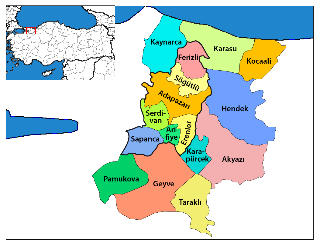
| تفصیل | Map of the districts of Sakarya province in Turkey. Created by Rarelibra 17:12, 4 December 2006 (UTC) for public domain use, using MapInfo Professional v8.5 and various mapping resources. Edited by One Homo Sapiens Corrected text where İ,Ş,ı,ğ,or ş occurs in name. Source: [statoids-com]. Increased font size and enhanced color differences among adjacent districts. |
| تریخ | ۴ دسمبر ۲۰۰۶ (original upload date) |
| سروت | No machine-readable source provided. Own work assumed (based on copyright claims). |
| لکھاری | No machine-readable author provided. Rarelibra assumed (based on copyright claims). |
لائسنس –
| میں، اس کم دے کاپیرائٹ دا مالک، اس کم نوں لوکاں واسطے دیندا واں۔ اے سارے جگ واسطے لاگو اے۔ کج ملکاں چ قانونی طور تے اے ممکن نئیں اے؛ اگر انج ای اے ے: میں ہر کسے نوں اس کم نوں کسے وی مقصد واسطے ورتن دا بغیر کسے شرط دے حق دیندا واں، اگر اوہ قانون دے خلاف نا ہوۓ۔ |
فائل دی تریخ
فائل نو اس ویلے دی حالت وچ ویکھن واسطے تاریخ/ویلے تے کلک کرو۔
| تریخ تے ویلہ | نکی مورت | پاسے | ورتن والا | تیپّݨی کرو | |
|---|---|---|---|---|---|
| موجودہ | ۲۳:۴۷, ۱۹ جنوری ۲۰۱۴ | | ۱,۰۵۳ × ۸۱۲ (۸۸ کلوبائٹ) | Chumwa | Nach der letzten Gebietsreform ist der zentrale Landkreis (in der Karte zuvor "Sakarya Merkez") aufgeteilt worden in: Adapazarı, Arifiye, Erenler und Serdivan. Die Kreise, die zur Großstadtkommune Sakarya gehören, sind umrandet worden. |
| ۰۶:۵۸, ۲۹ دسمبر ۲۰۰۸ |  | ۱,۰۵۶ × ۸۱۶ (۳۳ کلوبائٹ) | One Homo Sapiens | Corrected text where İ,Ş,ı,ğ,or ş occurs in name. Source: [statoids-com]. Increased font size and enhanced color differences among adjacent districts. | |
| ۲۱:۰۰, ۱۲ اپریل ۲۰۰۷ |  | ۷۷۶ × ۶۰۰ (۱۱۰ کلوبائٹ) | KureCewlik81 | ||
| ۲۲:۱۲, ۴ دسمبر ۲۰۰۶ |  | ۱,۰۵۶ × ۸۱۶ (۳۴ کلوبائٹ) | Rarelibra | Map of the districts of Sakarya province in Turkey. Created by ~~~~ for public domain use, using MapInfo Professional v8.5 and various mapping resources. |
فائل دی ورتوں
تھلے دتے گئے 15 صفحے اس فائل نال جُڑدے نیں
فائل ویاپک ورتوں
ایہہ دوجے وکیاں ایس فائل نوں ورتدے نیں –
- ar.wikipedia.org تے ورتوں
- arz.wikipedia.org تے ورتوں
- ast.wikipedia.org تے ورتوں
- azb.wikipedia.org تے ورتوں
- az.wikipedia.org تے ورتوں
- ca.wikipedia.org تے ورتوں
- ceb.wikipedia.org تے ورتوں
- ce.wikipedia.org تے ورتوں
- cs.wikipedia.org تے ورتوں
- cv.wikipedia.org تے ورتوں
- de.wikipedia.org تے ورتوں
- diq.wikipedia.org تے ورتوں
- en.wikipedia.org تے ورتوں
ایس فائل دا ویکھو ہور جگت ورتن .