
فائل:Strait tiran 83.jpg
ایس وکھالے دا ناپ: ۴۷۲ × ۵۹۹ پکسلز۔ دوجے ریزولوشنز: ۱۸۹ × ۲۴۰ پکسلز | ۳۷۸ × ۴۸۰ پکسلز | ۹۹۶ × ۱,۲۶۴ پکسلز ۔
اصل فائل (۹۹۶ × ۱,۲۶۴ پکسلز, فائل حجم: ۱۹۸ کلوبائٹ, MIME type: image/jpeg)
| تفصیل |
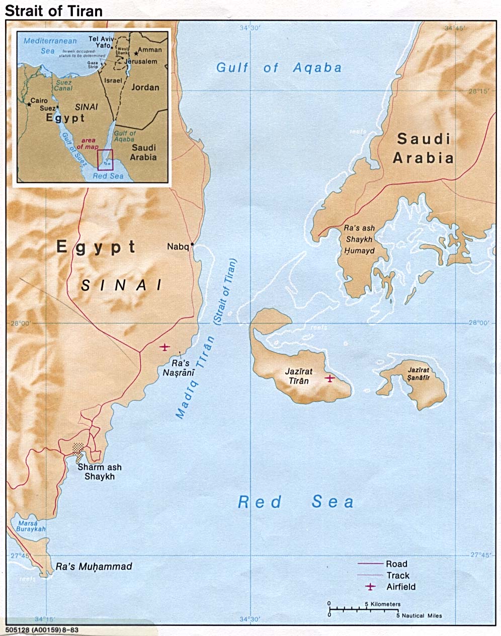
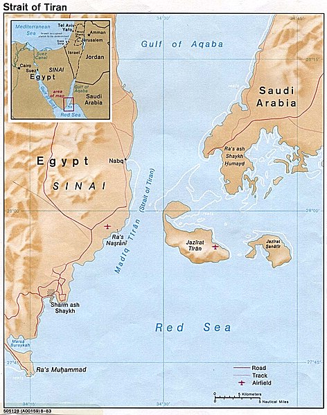
English: Strait of Tiran between Gulf of Aqaba and Red Sea |
|||
| تریخ | ||||
| سروت | http://www.lib.utexas.edu/maps/middle_east_and_asia/strait_tiran_83.jpg | |||
| لکھاری | "The following maps were produced by the U.S. Central Intelligence Agency, unless otherwise indicated." | |||
| اجازت (فائل نوں دوبارہ ورتنا) |
|
|||
| دوجے ورژن | العربيَّة |

فائل دی تریخ
فائل نو اس ویلے دی حالت وچ ویکھن واسطے تاریخ/ویلے تے کلک کرو۔
| تریخ تے ویلہ | نکی مورت | پاسے | ورتن والا | تیپّݨی کرو | |
|---|---|---|---|---|---|
| موجودہ | ۲۱:۴۶, ۲۳ فروری ۲۰۰۷ | | ۹۹۶ × ۱,۲۶۴ (۱۹۸ کلوبائٹ) | Monack | {{Information |Description = {{en|Strait of Tiran between Gulf of Aqaba and Red Sea}} |Source = http://www.lib.utexas.edu/maps/middle_east_and_asia/strait_tiran_83.jpg |Date = 1983 |Author = "The following maps were produced by the U.S. Central Intellige |
فائل دی ورتوں
تھلے دتے گئے 2 صفحے اس فائل نال جُڑدے نیں
فائل ویاپک ورتوں
ایہہ دوجے وکیاں ایس فائل نوں ورتدے نیں –
- af.wikipedia.org تے ورتوں
- als.wikipedia.org تے ورتوں
- ar.wikipedia.org تے ورتوں
- arz.wikipedia.org تے ورتوں
- az.wikipedia.org تے ورتوں
- be.wikipedia.org تے ورتوں
- bg.wikipedia.org تے ورتوں
- bn.wikipedia.org تے ورتوں
- ca.wikipedia.org تے ورتوں
- cs.wikipedia.org تے ورتوں
- da.wikipedia.org تے ورتوں
- de.wikipedia.org تے ورتوں
- el.wikipedia.org تے ورتوں
- en.wikipedia.org تے ورتوں
- en.wikivoyage.org تے ورتوں
- es.wikipedia.org تے ورتوں
- eu.wikipedia.org تے ورتوں
- fa.wikipedia.org تے ورتوں
- fi.wikipedia.org تے ورتوں
- fr.wikipedia.org تے ورتوں
- he.wikipedia.org تے ورتوں
- hy.wikipedia.org تے ورتوں
- id.wikipedia.org تے ورتوں
ایس فائل دا ویکھو ہور جگت ورتن .