
فائل:SyltSat.jpg
ایس وکھالے دا ناپ: ۴۴۵ × ۶۰۰ پکسلز۔ دوجے ریزولوشنز: ۱۷۸ × ۲۴۰ پکسلز | ۳۵۶ × ۴۸۰ پکسلز | ۶۶۸ × ۹۰۰ پکسلز ۔
اصل فائل (۶۶۸ × ۹۰۰ پکسلز, فائل حجم: ۴۰ کلوبائٹ, MIME type: image/jpeg)
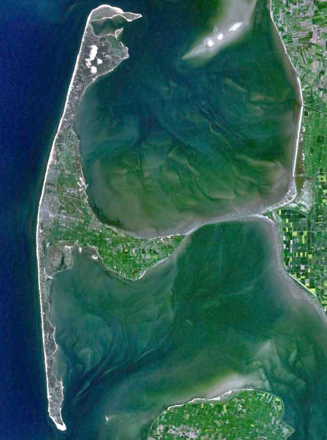
خلاصہ
| تفصیل |
English: The Island of Sylt in Northern Germany from the South. Satellite view. |
| تریخ | ۲۴ اپریل ۲۰۰۵ (upload date) |
| سروت | Satellite imagery taken from NASA World Wind software (by screenshot) |
| لکھاری | NASA |
لائسنس –
| This image is in the public domain because it is a screenshot from NASA’s globe software World Wind using a public domain layer, such as Blue Marble, MODIS, Landsat, SRTM, USGS or GLOBE.
|
 |
| Annotations | This image is annotated: View the annotations at Commons |
فائل دی تریخ
فائل نو اس ویلے دی حالت وچ ویکھن واسطے تاریخ/ویلے تے کلک کرو۔
| تریخ تے ویلہ | نکی مورت | پاسے | ورتن والا | تیپّݨی کرو | |
|---|---|---|---|---|---|
| موجودہ | ۰۰:۳۹, ۵ اگست ۲۰۰۶ | | ۶۶۸ × ۹۰۰ (۴۰ کلوبائٹ) | Ollio | original work of NASA - public domain picture made brigther by O. Lippuner (User --~~~~), without changing public domain status |
| ۱۹:۰۱, ۲۴ اپریل ۲۰۰۵ |  | ۶۶۸ × ۹۰۰ (۳۵۰ کلوبائٹ) | SeballaOne~commonswiki | The Island of Sylt in Northern Germany from the South. Created with World Wind {{PD-USGov-NASA}} Category:Islands Category:Satellite photos |
فائل دی ورتوں
تھلے دتے گئے 1 صفحے اس فائل نال جُڑدے نیں
فائل ویاپک ورتوں
ایہہ دوجے وکیاں ایس فائل نوں ورتدے نیں –
- af.wikipedia.org تے ورتوں
- ar.wikipedia.org تے ورتوں
- br.wikipedia.org تے ورتوں
- ca.wikipedia.org تے ورتوں
- da.wikipedia.org تے ورتوں
- de.wikipedia.org تے ورتوں
- en.wikipedia.org تے ورتوں
- eo.wikipedia.org تے ورتوں
- es.wikipedia.org تے ورتوں
- fa.wikipedia.org تے ورتوں
- frr.wikipedia.org تے ورتوں
- fr.wikipedia.org تے ورتوں
- fy.wikipedia.org تے ورتوں
- is.wikipedia.org تے ورتوں
- it.wikipedia.org تے ورتوں
- ko.wikipedia.org تے ورتوں
- ksh.wikipedia.org تے ورتوں
- mk.wikipedia.org تے ورتوں
- nds.wikipedia.org تے ورتوں
- nn.wikipedia.org تے ورتوں
- no.wikipedia.org تے ورتوں
- pt.wikipedia.org تے ورتوں
- stq.wikipedia.org تے ورتوں
- sv.wikipedia.org تے ورتوں
- xmf.wikipedia.org تے ورتوں
- zh.wikipedia.org تے ورتوں