
فائل:Topography Sri Lanka.jpg

ایس وکھالے دا ناپ: ۳۴۶ × ۶۰۰ پکسلز۔ دوجے ریزولوشنز: ۱۳۸ × ۲۴۰ پکسلز | ۲۷۷ × ۴۸۰ پکسلز | ۴۴۳ × ۷۶۸ پکسلز | ۵۹۱ × ۱,۰۲۴ پکسلز | ۱,۱۸۱ × ۲,۰۴۸ پکسلز | ۳,۰۰۰ × ۵,۲۰۰ پکسلز ۔
اصل فائل (۳,۰۰۰ × ۵,۲۰۰ پکسلز, فائل حجم: ۳.۲۷ میگابائٹ, MIME type: image/jpeg)
خلاصہ
| تفصیل |
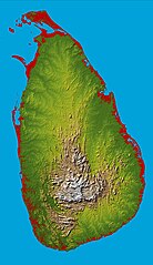
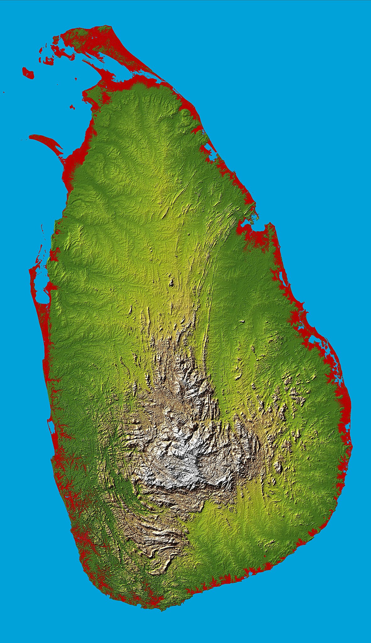
English: Topography of Sri Lanka, obtained from the Shuttle Radar Topography Mission of STS-99, aboard the Space Shuttle Endeavour. Heights below 10 meters (33 feet) above sea level have been colored red. |
| تریخ | |
| سروت | http://photojournal.jpl.nasa.gov/catalog/PIA06670 |
| لکھاری | National Aeronautics & Space Administration |
| Object location | | View this and other nearby images on: OpenStreetMap |
|---|
لائسنس –
| This file is in the public domain in the United States because it was solely created by NASA. NASA copyright policy states that "NASA material is not protected by copyright unless noted". (See Template:PD-USGov, NASA copyright policy page or JPL Image Use Policy.) | ||
 |
Warnings:
|
فائل دی تریخ
فائل نو اس ویلے دی حالت وچ ویکھن واسطے تاریخ/ویلے تے کلک کرو۔
| تریخ تے ویلہ | نکی مورت | پاسے | ورتن والا | تیپّݨی کرو | |
|---|---|---|---|---|---|
| موجودہ | ۲۲:۴۳, ۲۷ مارچ ۲۰۰۵ | | ۳,۰۰۰ × ۵,۲۰۰ (۳.۲۷ میگابائٹ) | FEXX | {{PD-USGov-NASA}} |
فائل دی ورتوں
تھلے دتے گئے 1 صفحے اس فائل نال جُڑدے نیں
فائل ویاپک ورتوں
ایہہ دوجے وکیاں ایس فائل نوں ورتدے نیں –
- af.wikipedia.org تے ورتوں
- ar.wikipedia.org تے ورتوں
- arz.wikipedia.org تے ورتوں
- ast.wikipedia.org تے ورتوں
- az.wikipedia.org تے ورتوں
- bcl.wikipedia.org تے ورتوں
- be.wikipedia.org تے ورتوں
- bg.wikipedia.org تے ورتوں
- bg.wiktionary.org تے ورتوں
- bn.wikipedia.org تے ورتوں
- ca.wikipedia.org تے ورتوں
- ceb.wikipedia.org تے ورتوں
- de.wikipedia.org تے ورتوں
- de.wikivoyage.org تے ورتوں
- diq.wikipedia.org تے ورتوں
- el.wikipedia.org تے ورتوں
- en.wikipedia.org تے ورتوں
- Sri Lanka
- Geography of Sri Lanka
- Portal:Sri Lanka
- User:Trengarasu
- User:Deavenger
- Outline of Sri Lanka
- User:RitigalaJayasena/UserBoxes/EquitySriLanka
- User:ProudIrishAspie
- User:Djodjo666
- User:Blackknight12/sandbox
- User:DaisyGeekyTransGirl
- Wikipedia:Graphics Lab/Map workshop/Archive/Dec 2015
- User:JFoog
- User:Okiloma
- Wikipedia:Userboxes/Politics by country/Sri Lanka
- en.wikiversity.org تے ورتوں
- eo.wikipedia.org تے ورتوں
- es.wikipedia.org تے ورتوں
- et.wikipedia.org تے ورتوں
- fa.wikipedia.org تے ورتوں
- fi.wikipedia.org تے ورتوں
- fr.wikipedia.org تے ورتوں
ایس فائل دا ویکھو ہور جگت ورتن .