
فائل:Torpedoed Japanese destroyer Yamakaze sinking on 25 June 1942.jpg

ایس وکھالے دا ناپ: ۷۵۹ × ۵۹۹ پکسلز۔ دوجے ریزولوشنز: ۳۰۴ × ۲۴۰ پکسلز | ۶۰۸ × ۴۸۰ پکسلز | ۹۷۳ × ۷۶۸ پکسلز | ۱,۲۸۰ × ۱,۰۱۱ پکسلز | ۲,۵۶۰ × ۲,۰۲۱ پکسلز | ۲,۹۳۷ × ۲,۳۱۹ پکسلز ۔
اصل فائل (۲,۹۳۷ × ۲,۳۱۹ پکسلز, فائل حجم: ۳.۸۴ میگابائٹ, MIME type: image/jpeg)
خلاصہ
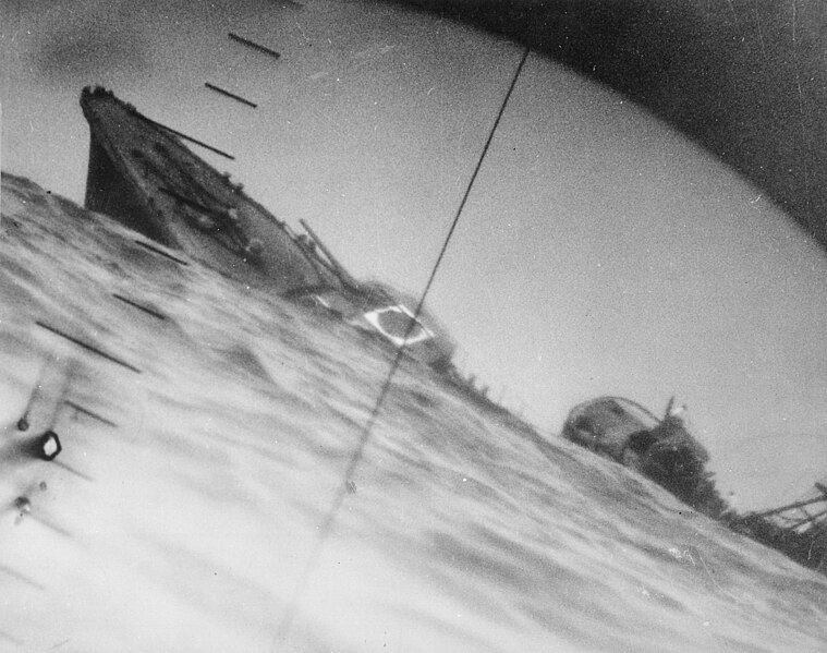
| تفصیل | Sinking of the Japanese destroyer Yamakaze on 25 June 1942 approximately 110 km southeast of Yokosuku, Japan, photographed through the periscope of the U.S. Navy submarine USS Nautilus (SS-168). This position is given in The Official Chronology of the U.S. Navy in World War II by Robert Cressman. NH 111751 says 75 miles southwest of Yokahama Harbor. Yokahama is near Yokosuku. | |||
| تریخ | ||||
| سروت |
|
|||
| لکھاری | U.S. Navy | |||
| دوجے ورژن | Official U.S. Navy photo NH 111751 from the U.S. Navy Naval History and Heritage Command |
| Camera location | | View this and other nearby images on: OpenStreetMap |
|---|
|
لائسنس –
This file is a work of a sailor or employee of the U.S. Navy, taken or made as part of that person's official duties. As a work of the U.S. federal government, it is in the public domain in the United States.
|
 | |
| ایہ فائل دے بارے چ دس اے جے اے کاپی حف دیاں روکاں توں کھلی اے تے نالدے رلدے حقاں توں وی۔ | ||
فائل دی تریخ
فائل نو اس ویلے دی حالت وچ ویکھن واسطے تاریخ/ویلے تے کلک کرو۔
| تریخ تے ویلہ | نکی مورت | پاسے | ورتن والا | تیپّݨی کرو | |
|---|---|---|---|---|---|
| موجودہ | ۱۱:۳۷, ۹ اکتوبر ۲۰۱۶ | | ۲,۹۳۷ × ۲,۳۱۹ (۳.۸۴ میگابائٹ) | Cobatfor | new NHHC file |
| ۰۱:۵۵, ۲۲ اگست ۲۰۰۷ |  | ۲,۹۸۵ × ۲,۰۴۸ (۱.۵ میگابائٹ) | BrokenSphere | == Summary == {{Information |Description=Torpedoed Japanese destroyer photographed through periscope of U.S.S. Wahoo or U.S.S. Nautilus, June 1942. (Navy) Exact Date Shot Unknown NARA FILE #: 080-G-418331 WAR & CONFLICT BOOK #: 1315 |Source=High resolutio |
فائل دی ورتوں
تھلے دتے گئے 1 صفحے اس فائل نال جُڑدے نیں
فائل ویاپک ورتوں
ایہہ دوجے وکیاں ایس فائل نوں ورتدے نیں –
- ar.wikipedia.org تے ورتوں
- azb.wikipedia.org تے ورتوں
- bg.wikipedia.org تے ورتوں
- bn.wikipedia.org تے ورتوں
- ca.wikipedia.org تے ورتوں
- cs.wikipedia.org تے ورتوں
- en.wikipedia.org تے ورتوں
- Periscope
- Pacific War
- USS Nautilus (SS-168)
- Salmon-class submarine
- Japanese destroyer Yamakaze (1936)
- Talk:Japanese destroyer Yamakaze (1936)
- Wikipedia:Featured pictures/History/World War II
- Allied submarines in the Pacific War
- List of shipwrecks in June 1942
- User talk:TomStar81/Archive 17
- Wikipedia:Featured pictures thumbs/51
- Wikipedia:Featured picture candidates/The death of the Imperial Japanese Destroyer Yamakaze as seen through the periscope of the submarine USS Nautilus (SS-168)
- Wikipedia:Featured picture candidates/April-2015
- Wikipedia:WikiProject Military history/News/May 2015/Articles
- Wikipedia:Wikipedia Signpost/2015-04-15/Featured content
- Wikipedia:Wikipedia Signpost/Single/2015-04-15
- List of maritime disasters in World War II
- Template:POTD/2018-06-25
- Wikipedia:Picture of the day/June 2018
- Wikipedia:Main Page history/2018 June 25
- es.wikipedia.org تے ورتوں
- eu.wikipedia.org تے ورتوں
- fa.wikipedia.org تے ورتوں
- fi.wikipedia.org تے ورتوں
- fr.wikipedia.org تے ورتوں
- hu.wikipedia.org تے ورتوں
- id.wikipedia.org تے ورتوں
- it.wikipedia.org تے ورتوں
- ja.wikipedia.org تے ورتوں
ایس فائل دا ویکھو ہور جگت ورتن .