
فائل:Turkish Strait disambig.svg

Size of this PNG preview of this SVG file: ۴۶۹ × ۳۸۸ پکسلز. دوجے ریزولوشنز: ۲۹۰ × ۲۴۰ پکسلز | ۵۸۰ × ۴۸۰ پکسلز | ۹۲۸ × ۷۶۸ پکسلز | ۱,۲۳۸ × ۱,۰۲۴ پکسلز | ۲,۴۷۶ × ۲,۰۴۸ پکسلز ۔
اصل فائل (ایس وی جی فائل، پکسل:۴۶۹ × ۳۸۸، فائل سائز: ۹۰ کلوبائٹ)
خلاصہ
| تفصیل |
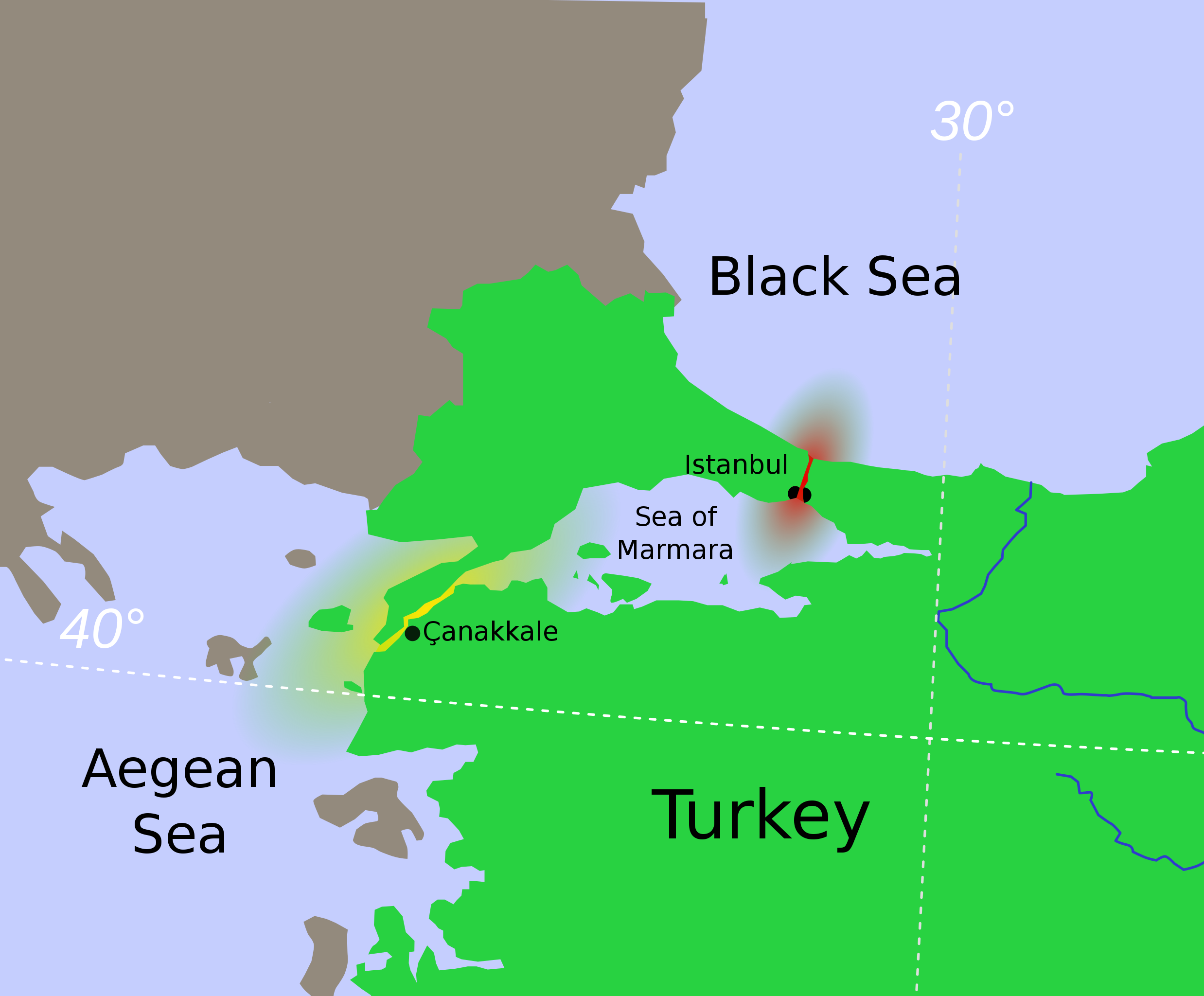
Hrvatski: Tjesnaci Bospor i Dardaneli Türkçe: Türk Boğazlarının harita üzerinde renkledirme ile açıklaması
Ελληνικά: τα Στενά του Βοσπόρου Українська: Турецькі протоки.
Босфор
Дарданелли मराठी: तुर्कस्तानमधील बोस्फोरस व डार्डेनेल्झ ह्या सामुद्रधुन्या 日本語: 海峡地帯(トルコ) |
||
| تریخ | |||
| سروت | Modified from File:Vertrag sevres otoman.svg, created by Thomas Steiner. | ||
| لکھاری | User:Interiot | ||
| دوجے ورژن |
[]
|
||
| SVG genesis |


.svg)


لائسنس –
ایس فائل نوں کریٹو کامنز Attribution 2.5 جنرک لائسنس دتا گیا.
- تہانوں کھلھ اے:
- حصہ کرنا – کاپی، ونڈنا تے کم بھیجنا
- فیر رلانا – کم نوں فٹ کرنا
- تھلے دتیاں شرطاں نال:
- کس دے ناں – تسیں لازمی ایس کم دے بناں والے بارے دسو جنج اونے آکھیا اے یا جنج لسنس چ آکھیا گیا ہے۔
- اکو جہا شئیر کرو۔ – اگر تسیں بدلدے یا ایس کم تے بناندے تے بنن والے کم نوں اینج دے لسنس نال ای ونڈو گے۔
پہلا اپلوڈ دا ریکارڈ
The original description page was here. All following user names refer to en.wikipedia.
- 2007-01-16 22:04 Interiot 469×388× (94044 bytes) oops
- 2007-01-16 20:59 Interiot 469×388× (122640 bytes) actually, make it clear that Istanbul straddles the strait
- 2007-01-16 20:47 Interiot 469×388× (90212 bytes) Disambiguation for [[Turkish Straights]]. Modified from [[:Image:Vertrag sevres otoman.svg]], created by [[:de:Benutzer:Thire|Thomas Steiner]]. {{cc-by-sa-2.5}}
فائل دی تریخ
فائل نو اس ویلے دی حالت وچ ویکھن واسطے تاریخ/ویلے تے کلک کرو۔
| تریخ تے ویلہ | نکی مورت | پاسے | ورتن والا | تیپّݨی کرو | |
|---|---|---|---|---|---|
| موجودہ | ۱۱:۲۱, ۲۶ جنوری ۲۰۱۲ | | ۴۶۹ × ۳۸۸ (۹۰ کلوبائٹ) | OgreBot | (BOT): Reverting to most recent version before archival |
| ۱۱:۲۱, ۲۶ جنوری ۲۰۱۲ |  | ۴۶۹ × ۳۸۸ (۹۲ کلوبائٹ) | OgreBot | (BOT): Uploading old version of file from en.wikipedia; originally uploaded on 2007-01-16 22:04:20 by Interiot | |
| ۱۱:۲۱, ۲۶ جنوری ۲۰۱۲ |  | ۴۶۹ × ۳۸۸ (۱۲۰ کلوبائٹ) | OgreBot | (BOT): Uploading old version of file from en.wikipedia; originally uploaded on 2007-01-16 20:59:55 by Interiot | |
| ۱۱:۲۱, ۲۶ جنوری ۲۰۱۲ |  | ۴۶۹ × ۳۸۸ (۸۸ کلوبائٹ) | OgreBot | (BOT): Uploading old version of file from en.wikipedia; originally uploaded on 2007-01-16 20:47:38 by Interiot | |
| ۲۱:۱۶, ۱۹ دسمبر ۲۰۰۸ |  | ۴۶۹ × ۳۸۸ (۹۰ کلوبائٹ) | RafaAzevedo | {{Information |Description={{en|1=Disambiguation for Turkish Straits. {{legend|#eb0000|Bosporus Strait}} {{legend|#ffe605|Dardanelles Strait}} == License == Modified from Image:Vertrag sevres otoman.svg, created by |
فائل دی ورتوں
تھلے دتے گئے 1 صفحے اس فائل نال جُڑدے نیں
فائل ویاپک ورتوں
ایہہ دوجے وکیاں ایس فائل نوں ورتدے نیں –
- af.wikipedia.org تے ورتوں
- ar.wikipedia.org تے ورتوں
- azb.wikipedia.org تے ورتوں
- az.wikipedia.org تے ورتوں
- bg.wikipedia.org تے ورتوں
- bn.wikipedia.org تے ورتوں
- bs.wikipedia.org تے ورتوں
- ca.wikipedia.org تے ورتوں
- da.wikipedia.org تے ورتوں
- el.wikipedia.org تے ورتوں
- en.wikipedia.org تے ورتوں
- Bosporus
- Dardanelles
- Montreux Convention Regarding the Regime of the Straits
- Sea of Marmara
- Dardanus (son of Zeus)
- Truman Doctrine
- Gallipoli campaign
- Landing at Cape Helles
- Naval operations in the Dardanelles campaign
- London Straits Convention
- Treaty of Hünkâr İskelesi
- Chanak Crisis
- Turkish straits
- Constantinople Agreement
- Turkish straits crisis
- User:Chickstarr404/Gather lists/13386 – "A Travelers Alphabet" by Stephen Runciman
- International Straits Commission
- User:Abyssal/bla
- en.wiktionary.org تے ورتوں
ایس فائل دا ویکھو ہور جگت ورتن .