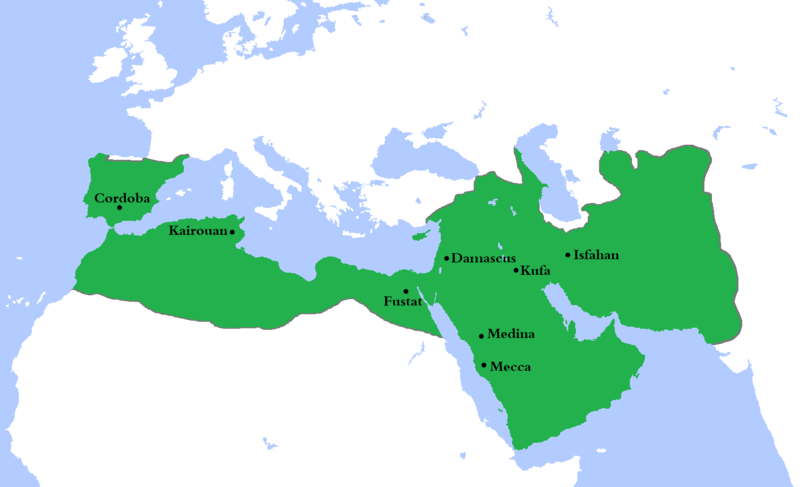
فائل:Umayyad750ADloc.png

ایس وکھالے دا ناپ: ۸۰۰ × ۴۸۷ پکسلز۔ دوجے ریزولوشنز: ۳۲۰ × ۱۹۵ پکسلز | ۶۴۰ × ۳۹۰ پکسلز | ۱,۰۲۴ × ۶۲۴ پکسلز | ۱,۴۸۱ × ۹۰۲ پکسلز ۔
اصل فائل (۱,۴۸۱ × ۹۰۲ پکسلز, فائل حجم: ۴۴ کلوبائٹ, MIME type: image/png)
فائل دی تریخ
فائل نو اس ویلے دی حالت وچ ویکھن واسطے تاریخ/ویلے تے کلک کرو۔
| تریخ تے ویلہ | نکی مورت | پاسے | ورتن والا | تیپّݨی کرو | |
|---|---|---|---|---|---|
| موجودہ | ۰۳:۲۳, ۵ اگست ۲۰۲۰ |  | ۱,۴۸۱ × ۹۰۲ (۴۴ کلوبائٹ) | Ozan33Ankara | Corrected borders based on: The expansion of the Muslim Caliphate until 750, from William R. Shepherd's Historical Atlas. |
| ۲۰:۲۴, ۱۱ اپریل ۲۰۱۳ |  | ۱,۴۸۱ × ۹۰۲ (۳۰ کلوبائٹ) | HistoryofIran | {{subst:Upload marker added by en.wp UW}} {{Information |Description = {{en|Made the map more presice, the Umayyads never controlled Tabaristan because of the Dabuyid dynasty, but the Abbasids did that later.}} |Source = http://en.wikipedia.org/wiki/Fi... | |
| ۲۰:۵۵, ۱۰ اپریل ۲۰۱۳ |  | ۱,۴۸۱ × ۹۰۲ (۳۷ کلوبائٹ) | Khateeb88 | Added the major cities of the Umayyad Caliphate: Damascus, Kufa, Isfahan, Mecca, Medina, Fustat, Kairouan, and Cordoba. | |
| ۲۰:۵۴, ۱۰ اپریل ۲۰۱۳ |  | ۱,۴۸۱ × ۹۰۲ (۳۷ کلوبائٹ) | Khateeb88 | Added the major cities of the Umayyad Caliphate: Damascus, Kufa, Isfahan, Mecca, Medina, Fustat, Kairouan, and Cordoba. | |
| ۲۱:۱۷, ۲۲ اپریل ۲۰۰۹ |  | ۱,۴۸۱ × ۹۰۲ (۵۰ کلوبائٹ) | Gabagool | some corrections.. | |
| ۲۱:۱۰, ۲۰ اپریل ۲۰۰۹ |  | ۱,۴۸۱ × ۹۰۲ (۵۰ کلوبائٹ) | Gabagool | {{Information |Description={{en|1=Locator map for the Umayyad Caliphate at its greatest extent, c. AD 750. (Partially based on ''Atlas of World History'' (2007) - World 500-750, map.)}} |Source=Own work by uploader |Author=Gabagool / Ja |
فائل دی ورتوں
تھلے دتے گئے 3 صفحے اس فائل نال جُڑدے نیں
فائل ویاپک ورتوں
ایہہ دوجے وکیاں ایس فائل نوں ورتدے نیں –
- af.wikipedia.org تے ورتوں
- als.wikipedia.org تے ورتوں
- an.wikipedia.org تے ورتوں
- ast.wikipedia.org تے ورتوں
- av.wikipedia.org تے ورتوں
- az.wikipedia.org تے ورتوں
- ba.wikipedia.org تے ورتوں
- be.wikipedia.org تے ورتوں
- bg.wikipedia.org تے ورتوں
- bn.wikipedia.org تے ورتوں
- br.wikipedia.org تے ورتوں
- bs.wikipedia.org تے ورتوں
- ca.wikipedia.org تے ورتوں
- ckb.wikipedia.org تے ورتوں
- cy.wikipedia.org تے ورتوں
- da.wikipedia.org تے ورتوں
- de.wikipedia.org تے ورتوں
- el.wikipedia.org تے ورتوں
- en.wikipedia.org تے ورتوں
ایس فائل دا ویکھو ہور جگت ورتن .


