
فائل:Varanasi locator.png

ایس وکھالے دا ناپ: ۵۶۲ × ۵۹۹ پکسلز۔ دوجے ریزولوشنز: ۲۲۵ × ۲۴۰ پکسلز | ۴۵۰ × ۴۸۰ پکسلز | ۷۲۱ × ۷۶۸ پکسلز | ۹۶۱ × ۱,۰۲۴ پکسلز | ۱,۷۹۳ × ۱,۹۱۱ پکسلز ۔
اصل فائل (۱,۷۹۳ × ۱,۹۱۱ پکسلز, فائل حجم: ۳۳۶ کلوبائٹ, MIME type: image/png)
خلاصہ
| تفصیل |
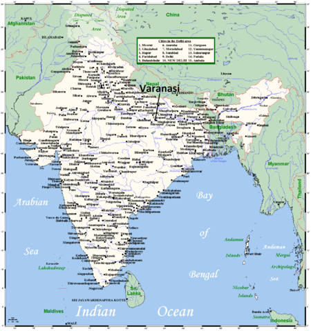
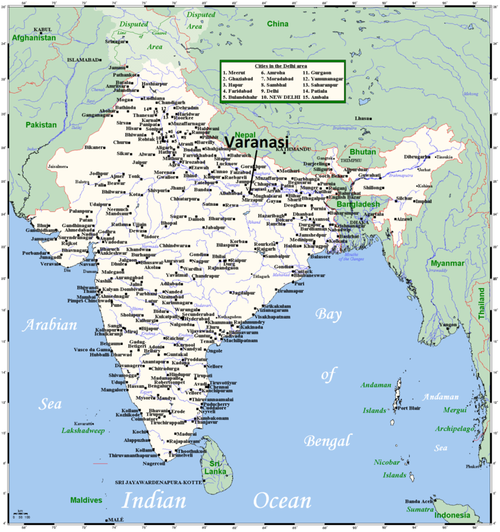
English: A map showing India's cities and main towns.
I have endeavoured to include every city in India whose population is 100,000 or more. If you spot an oversight, leave a message on my talk page and I'll see if I can do anything about it. |
| تریخ | ۷ اگست ۲۰۰۸ (original upload date) |
| سروت | This map's source is here, with the uploader's modifications, and the GMT homepage says that the tools are released under the GNU General Public License. |
| لکھاری | Kelisi at English وکیپیڈیا, Varanasi locator added by Dr. Blofeld |
لائسنس –
Kelisi from en.wikipedia.org، اس کم دے کاپیرائٹ دا مالک، اس کم نوں اس لائسنس دے مطابق چھاپدا واں:
| ایس فائل نوں کریٹو کامنز Attribution 2.5 پولینڈ لائسنس دتا گیا. Subject to disclaimers. | ||
| کس دے ناں: Kelisi from en.wikipedia.org | ||
| ||
| اس لائسنس دا ٹیگ GFDL دے مطابق اس فائل چ پایا گیا اے licensing update۔ |

|
کاپی کرن، ونڈن تے بدلن دی ایس ڈوکومنٹ لئی اجازت دتی جاندی اے ایہناں GNU Free Documentation License, Version 1.2 شرطاں نال یا مگروں کسے وی چھپے ورین Free Software Foundation توں بنا کسے انویرینٹ سیکشن دے، ناں فرنٹ کور لکھت تے ناں بیک کور لکھت دے۔ لسنس دی اک کاپی سیکشن وچ ہیگی اے جہدا ناں اے GNU Free Documentation License۔ Subject to disclaimers. |
پہلا اپلوڈ دا ریکارڈ
Transferred from en.wikipedia to Commons by Dharmadhyaksha using CommonsHelper.
The original description page was here. All following user names refer to en.wikipedia.
- 2009-05-20 12:15 ESkog 1793×1911× (214652 bytes) Reverted to version as of 23:55, 7 August 2008 (vandalism)
- 2009-05-20 11:52 Shalabhmaheshwary 1793×1911× (277217 bytes)
- 2008-08-07 23:55 Kelisi 1793×1911× (214652 bytes) A map showing India's cities and main towns. This map's source is [http://www.aquarius.ifm-geomar.de/ here], with the uploader's modifications, and the [http://gmt.soest.hawaii.edu/ GMT homepage] says that the tools are released under the GN
فائل دی تریخ
فائل نو اس ویلے دی حالت وچ ویکھن واسطے تاریخ/ویلے تے کلک کرو۔
| تریخ تے ویلہ | نکی مورت | پاسے | ورتن والا | تیپّݨی کرو | |
|---|---|---|---|---|---|
| موجودہ | ۰۰:۴۸, ۳۱ اکتوبر ۲۰۱۲ | | ۱,۷۹۳ × ۱,۹۱۱ (۳۳۶ کلوبائٹ) | Blofeld Dr. | {{Information |Description ={{en|1=g}} |Source =g |Author =g |Date =g |Permission = |other_versions = }} |
فائل دی ورتوں
تھلے دتے گئے 1 صفحے اس فائل نال جُڑدے نیں
فائل ویاپک ورتوں
ایہہ دوجے وکیاں ایس فائل نوں ورتدے نیں –
- bn.wikipedia.org تے ورتوں
- ja.wikipedia.org تے ورتوں
- sq.wikipedia.org تے ورتوں
- ur.wikipedia.org تے ورتوں