
فائل:Vorderhopfreben Üntschenspitze 1.jpg

ایس وکھالے دا ناپ: ۸۰۰ × ۳۲۲ پکسلز۔ دوجے ریزولوشنز: ۳۲۰ × ۱۲۹ پکسلز | ۶۴۰ × ۲۵۷ پکسلز | ۱,۰۲۴ × ۴۱۲ پکسلز | ۱,۲۸۰ × ۵۱۴ پکسلز | ۲,۵۶۰ × ۱,۰۲۹ پکسلز | ۶,۴۳۹ × ۲,۵۸۸ پکسلز ۔
اصل فائل (۶,۴۳۹ × ۲,۵۸۸ پکسلز, فائل حجم: ۴.۸۳ میگابائٹ, MIME type: image/jpeg)
|

| تفصیل |
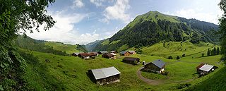
Deutsch: 180° Panorama auf dem Vorsäß Vorderhopfreben mit Blick auf das höher gelegene Vorsäß „Schalzbach“ in Schoppernau. Beide Siedlungen gehören zur Stufe zwei der Dreistufenwirtschaft. Rechts im Bild die Üntschenspitze 2.135m.
English: 180 ° panorama on the Alps Vorderhopfreben with a view of the higher-lying Alps Schalzbach in Schoppernau. Both settlements are in stage two of the three-stage Transhumance in the Alps. Right in the picture Üntschenspitze 2,135m.
Français : Panorama à 180 ° sur des alpages de Schoppernau, dans le Vorarlberg, en Autriche. Les deux alpages de Vorderhopfreben et Schalzbach visibles ici sont des stations intermédiaires entre la vallée et les alpages d'altitude. Sur la droite de l'image on peut voir le sommet de l'Üntschenspitze (2 135 m).
|
||
| تریخ | |||
| سروت | آپݨا کم | ||
| لکھاری | Böhringer Friedrich | ||
| اجازت (فائل نوں دوبارہ ورتنا) |
میں، اس کم دے کاپیرائٹ دا مالک، اس کم نوں اس لائسنس دے مطابق چھاپدا واں: ایس فائل نوں کریٹو کامنز Attribution 2.5 جنرک لائسنس دتا گیا.
|
||
| دوجے ورژن |
|


| Camera location | | View this and other nearby images on: OpenStreetMap |
|---|
This Photo was taken by Böhringer Friedrich.
|
Feel free to use my photos, but please mention me as the author and if you want send me a message. or (rufre@lenz-nenning.at) |
| Annotations | This image is annotated: View the annotations at Commons |
فائل دی تریخ
فائل نو اس ویلے دی حالت وچ ویکھن واسطے تاریخ/ویلے تے کلک کرو۔
| تریخ تے ویلہ | نکی مورت | پاسے | ورتن والا | تیپّݨی کرو | |
|---|---|---|---|---|---|
| موجودہ | ۰۱:۴۴, ۱۳ جولائی ۲۰۰۹ | ۶,۴۳۹ × ۲,۵۸۸ (۴.۸۳ میگابائٹ) | Böhringer | stitching errors corrected 2. Versuch | |
| ۰۱:۳۵, ۱۳ جولائی ۲۰۰۹ | ۶,۴۳۹ × ۲,۵۸۸ (۴.۸۳ میگابائٹ) | Böhringer | stitching errors corrected | ||
| ۰۰:۱۶, ۷ جولائی ۲۰۰۹ | ۶,۴۳۹ × ۲,۵۸۸ (۵.۴۶ میگابائٹ) | Böhringer | {{Information |Description= {{de|180° Panorama auf dem Vorsäß Vorderhopfreben mit Blick auf das höher gelegene Vorsäß „Schalzbach“ in Schoppernau. Beide Siedlungen gehören zur Stufe zwei der [[:de:Dreistu |
فائل دی ورتوں
تھلے دتے گئے 1 صفحے اس فائل نال جُڑدے نیں
فائل ویاپک ورتوں
ایہہ دوجے وکیاں ایس فائل نوں ورتدے نیں –
- ar.wikipedia.org تے ورتوں
- azb.wikipedia.org تے ورتوں
- az.wikipedia.org تے ورتوں
- bs.wikipedia.org تے ورتوں
- de.wikipedia.org تے ورتوں
- en.wikipedia.org تے ورتوں
- en.wikibooks.org تے ورتوں
- eo.wikipedia.org تے ورتوں
- fr.wikipedia.org تے ورتوں
- gl.wikipedia.org تے ورتوں
- hy.wikipedia.org تے ورتوں
- kn.wikipedia.org تے ورتوں
- krc.wikipedia.org تے ورتوں
- mad.wikipedia.org تے ورتوں
- mg.wikipedia.org تے ورتوں
- min.wikipedia.org تے ورتوں
- nl.wikipedia.org تے ورتوں
- pl.wikipedia.org تے ورتوں
- sd.wikipedia.org تے ورتوں
- sl.wikipedia.org تے ورتوں
- tr.wikipedia.org تے ورتوں
- Vorarlberg
- Vikipedi:Seçkin resimler/Mekânlar/Panorama
- Vikipedi:Seçkin resim adayları/Vorderhopfreben Üntschenspitze 1.jpg
- Schoppernau
- Vikipedi:Seçkin resim adayları/Arşiv/Şubat 2010
- Vikipedi:Günün seçkin resmi/Ağustos 2011
- Şablon:GSR/2011-08-14
- Vikipedi:Seçkin resimler/Ana sayfaya çıkmış resimler/2011 listesi
- Vikipedi:Seçkin resimler/Ana sayfaya çıkmış resimler/2014 listesi
- Vikipedi:Günün seçkin resmi/Aralık 2014
- Şablon:GSR/2014-12-08
- Şablon:GSR/2017-09-29
- Vikipedi:Günün seçkin resmi/Eylül 2017
- uk.wikipedia.org تے ورتوں
- vi.wikipedia.org تے ورتوں