
فائل:WW2-Holocaust-Europe.png

اصل فائل (۱,۳۱۰ × ۱,۰۹۰ پکسلز, فائل حجم: ۶۳۹ کلوبائٹ, MIME type: image/png)
خلاصہ
| تفصیل |
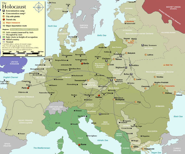
Map of the Holocaust in Europe during World War II, 1939-1945.
|
| تریخ | |
| سروت | Self-made by User:Dna-Dennis, using information from USHMM & Wikipedia. |
| لکھاری | User:Dna-Dennis |
| اجازت (فائل نوں دوبارہ ورتنا) |
CC, see below. The map is completely unrestricted for any Wikipedia/Wikimedia project. |
| دوجے ورژن |
[]
|


.png)


.png)


.png)

|
File:WW2 Holocaust Europe map-fr.svg is a vector version of this file. It should be used in place of this PNG file when not inferior.
File:WW2-Holocaust-Europe.png → File:WW2 Holocaust Europe map-fr.svg
For more information, see Help:SVG. |
 |
لائسنس –
- تہانوں کھلھ اے:
- حصہ کرنا – کاپی، ونڈنا تے کم بھیجنا
- فیر رلانا – کم نوں فٹ کرنا
- تھلے دتیاں شرطاں نال:
- کس دے ناں – تسیں لازمی ایس کم دے بناں والے بارے دسو جنج اونے آکھیا اے یا جنج لسنس چ آکھیا گیا ہے۔
فائل دی تریخ
فائل نو اس ویلے دی حالت وچ ویکھن واسطے تاریخ/ویلے تے کلک کرو۔
| تریخ تے ویلہ | نکی مورت | پاسے | ورتن والا | تیپّݨی کرو | |
|---|---|---|---|---|---|
| موجودہ | ۱۸:۵۷, ۲۹ اکتوبر ۲۰۰۹ | | ۱,۳۱۰ × ۱,۰۹۰ (۶۳۹ کلوبائٹ) | Flying Saucer | moved Vaivara to it's right place |
| ۰۸:۴۱, ۲۰ دسمبر ۲۰۰۷ |  | ۱,۳۱۰ × ۱,۰۹۰ (۸۲۶ کلوبائٹ) | Dna-webmaster~commonswiki | new version without "Axis cooperating" in legend | |
| ۰۷:۰۰, ۲۰ دسمبر ۲۰۰۷ |  | ۱,۳۱۰ × ۱,۰۹۰ (۸۲۴ کلوبائٹ) | Dna-webmaster~commonswiki | Now entire West Prussia and Wartheland is included in the Third Reich | |
| ۲۱:۴۲, ۱۹ دسمبر ۲۰۰۷ |  | ۱,۳۱۰ × ۱,۰۹۰ (۸۲۸ کلوبائٹ) | Dna-webmaster~commonswiki | still not Da Vinci, but errors have been corrected (Germany borders West/East), West & East Prussia borders/coloring and Poland General Government corrected borders. | |
| ۱۵:۴۶, ۱۷ دسمبر ۲۰۰۷ |  | ۱,۳۱۰ × ۱,۰۹۰ (۸۲۵ کلوبائٹ) | Dna-webmaster~commonswiki | new map with 1942 borders, not Da Vinci, but here it goes... | |
| ۱۸:۳۲, ۱۹ اکتوبر ۲۰۰۷ |  | ۱,۳۱۰ × ۱,۰۹۰ (۷۶۶ کلوبائٹ) | Dna-webmaster~commonswiki | and another update | |
| ۱۷:۲۱, ۱۹ اکتوبر ۲۰۰۷ |  | ۱,۳۱۰ × ۱,۰۹۰ (۷۷۱ کلوبائٹ) | Dna-webmaster~commonswiki | quick fix | |
| ۱۷:۱۱, ۱۹ اکتوبر ۲۰۰۷ |  | ۱,۳۱۰ × ۱,۰۹۰ (۷۷۱ کلوبائٹ) | Dna-webmaster~commonswiki | {{Information |Description=Map of the Holocaust in Europe during World War II, 1939-1945. <br> This map shows all extermination camps (or ''death camps''), most major concentration camps, work camps, prison camps, ghettos, major deportation routes and maj |
فائل دی ورتوں
تھلے دتے گئے 1 صفحے اس فائل نال جُڑدے نیں
فائل ویاپک ورتوں
ایہہ دوجے وکیاں ایس فائل نوں ورتدے نیں –
- af.wikipedia.org تے ورتوں
- ar.wikipedia.org تے ورتوں
- az.wikipedia.org تے ورتوں
- be-tarask.wikipedia.org تے ورتوں
- be.wikipedia.org تے ورتوں
- bn.wikipedia.org تے ورتوں
- ca.wikipedia.org تے ورتوں
- cs.wikipedia.org تے ورتوں
- de.wikipedia.org تے ورتوں
- el.wikipedia.org تے ورتوں
- en.wikipedia.org تے ورتوں
- Auschwitz concentration camp
- Extermination camp
- Sobibor extermination camp
- Drancy internment camp
- White Buses
- Vel' d'Hiv Roundup
- Template:Image frame
- German war crimes
- René Bousquet
- Holocaust trains
- Portal:Genocide/Selected article
- Portal:Genocide/Selected article/8
- Mechelen transit camp
- User:Dna-webmaster/Projects
- Jewish ghettos in Europe
- List of Jewish ghettos in Europe during World War II
- Template:Image frame/doc
- User:Jnestorius/Resources
- Wikipedia:Featured picture candidates/January-2015
- Wikipedia:Featured picture candidates/Map of the Holocaust in Europe
- The Holocaust in Hungary
- Emigration of Jews from Nazi Germany and German-occupied Europe
- Talk:The Holocaust/Archive 31
- Template:Image frame/sandbox
- Reich Security Head Office Referat IV B4
- Genocides in history (World War I through World War II)
- User:Buidhe/fork
- en.wikibooks.org تے ورتوں
- es.wikipedia.org تے ورتوں
- fa.wikipedia.org تے ورتوں
- fi.wikipedia.org تے ورتوں
- fi.wikibooks.org تے ورتوں
- fr.wikipedia.org تے ورتوں
ایس فائل دا ویکھو ہور جگت ورتن .