
فائل:Western-ganga-empire-map.svg

Size of this PNG preview of this SVG file: ۵۶۵ × ۶۰۰ پکسلز. دوجے ریزولوشنز: ۲۲۶ × ۲۴۰ پکسلز | ۴۵۲ × ۴۸۰ پکسلز | ۷۲۳ × ۷۶۸ پکسلز | ۹۶۴ × ۱,۰۲۴ پکسلز | ۱,۹۲۹ × ۲,۰۴۸ پکسلز | ۱,۶۵۱ × ۱,۷۵۳ پکسلز ۔
اصل فائل (ایس وی جی فائل، پکسل:۱,۶۵۱ × ۱,۷۵۳، فائل سائز: ۴۳۰ کلوبائٹ)
خلاصہ
I used Image:India-locator-map-blank.svg as base and edited myself using inkspace and created it by looking at the following sources.
- Malini Adiga (2006), The Making of Southern Karnataka: Society, Polity and Culture in the early medieval period, AD 400-1030, Orient Longman, Chennai, , ISBN 81 250 2912 5 , p121
- Dr. Suryanath U. Kamath, A Concise history of Karnataka from pre-historic times to the present, Jupiter books, MCC, 2001 (Reprinted 2002) (page no - 329)
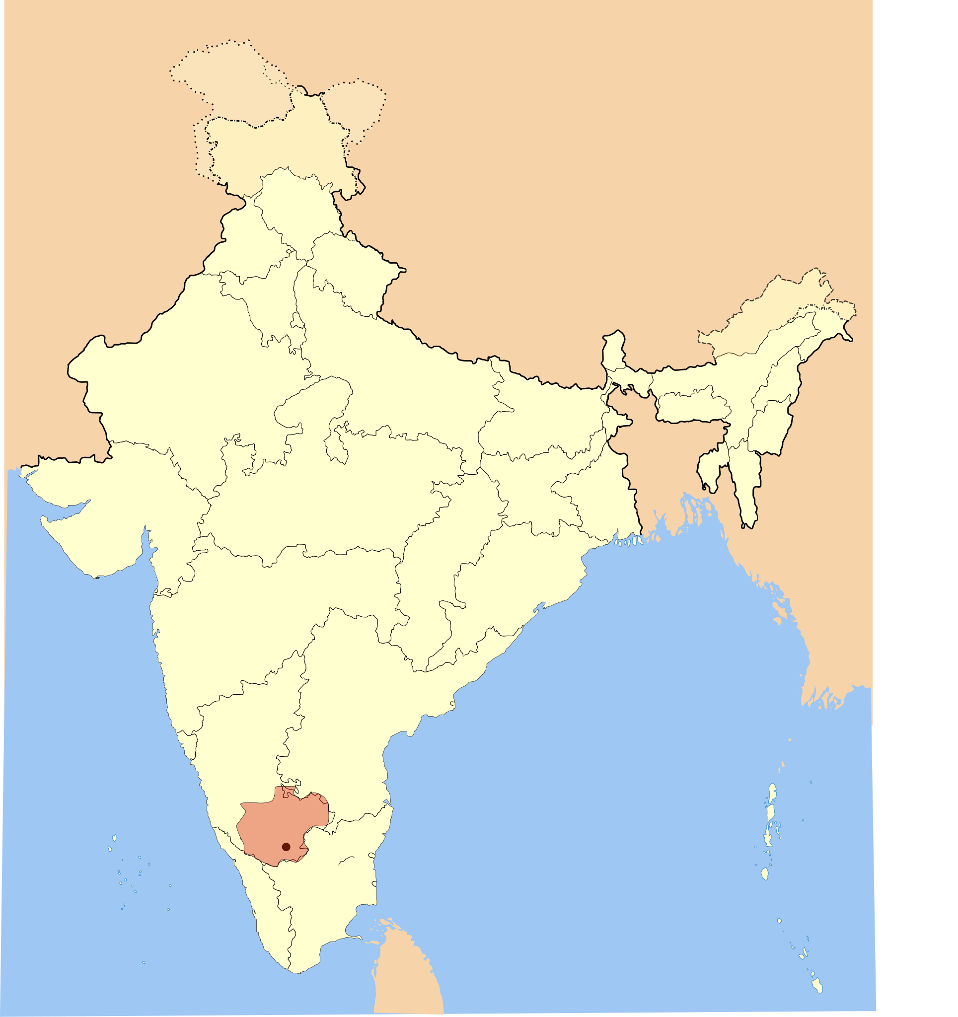
The Gangadomains map pertains to the "Western Ganga Dynasty" (Western Gangas). The double shaded region was under the control of their feudatories in 1st version. I deleted the double shade to avoid confusion and internalisation overhead in 2nd picture.
| تفصیل | Western Ganga Empire Map |
| تریخ | |
| سروت | آپݨا کم |
| لکھاری | Mlpkr |
لائسنس –
میں، اس کم دے کاپیرائٹ دا مالک، اس کم نوں اس لائسنس دے مطابق چھاپدا واں:

|
کاپی کرن، ونڈن تے بدلن دی ایس ڈوکومنٹ لئی اجازت دتی جاندی اے ایہناں GNU Free Documentation License, Version 1.2 شرطاں نال یا مگروں کسے وی چھپے ورین Free Software Foundation توں بنا کسے انویرینٹ سیکشن دے، ناں فرنٹ کور لکھت تے ناں بیک کور لکھت دے۔ لسنس دی اک کاپی سیکشن وچ ہیگی اے جہدا ناں اے GNU Free Documentation License۔ |
| ایس فائل نوں کریٹو کامنز Attribution 2.5 پولینڈ لائسنس دتا گیا. | ||
| ||
| اس لائسنس دا ٹیگ GFDL دے مطابق اس فائل چ پایا گیا اے licensing update۔ |
ایس فائل نوں Creative Commons Attribution-Share Alike 2.5 Generic, 2.0 Generic and 1.0 Generic لسنس دتا گیا اے۔
- تہانوں کھلھ اے:
- حصہ کرنا – کاپی، ونڈنا تے کم بھیجنا
- فیر رلانا – کم نوں فٹ کرنا
- تھلے دتیاں شرطاں نال:
- کس دے ناں – تسیں لازمی ایس کم دے بناں والے بارے دسو جنج اونے آکھیا اے یا جنج لسنس چ آکھیا گیا ہے۔
- اکو جہا شئیر کرو۔ – اگر تسیں بدلدے یا ایس کم تے بناندے تے بنن والے کم نوں اینج دے لسنس نال ای ونڈو گے۔
تسیں اپنی مرضی دا لائسنس چݨ سکدے اوہ۔
فائل دی تریخ
فائل نو اس ویلے دی حالت وچ ویکھن واسطے تاریخ/ویلے تے کلک کرو۔
| تریخ تے ویلہ | نکی مورت | پاسے | ورتن والا | تیپّݨی کرو | |
|---|---|---|---|---|---|
| موجودہ | ۰۵:۴۰, ۲۸ مئی ۲۰۰۷ | | ۱,۶۵۱ × ۱,۷۵۳ (۴۳۰ کلوبائٹ) | Mlpkr | I used Image:India-locator-map-blank.svg as base and edited myself using inkspace and created it by looking at the following sources. * Malini Adiga (2006), The Making of Southern Karnataka: Society, Polity and Culture in the early medieval period, |
| ۰۵:۱۶, ۲۸ مئی ۲۰۰۷ |  | ۱,۶۵۱ × ۱,۷۵۳ (۴۳۱ کلوبائٹ) | Mlpkr | I used Image:India-locator-map-blank.svg as base and edited myself using inkspace and created it by looking at the following sources. * Malini Adiga (2006), The Making of Southern Karnataka: Society, Polity and Culture in the early medieval period, |
فائل دی ورتوں
تھلے دتے گئے 1 صفحے اس فائل نال جُڑدے نیں
فائل ویاپک ورتوں
ایہہ دوجے وکیاں ایس فائل نوں ورتدے نیں –
- ar.wikipedia.org تے ورتوں
- azb.wikipedia.org تے ورتوں
- bn.wikipedia.org تے ورتوں
- ca.wikipedia.org تے ورتوں
- en.wikipedia.org تے ورتوں
- es.wikipedia.org تے ورتوں
- fa.wikipedia.org تے ورتوں
- fr.wikipedia.org تے ورتوں
- hi.wikipedia.org تے ورتوں
- hu.wikipedia.org تے ورتوں
- id.wikipedia.org تے ورتوں
- it.wikipedia.org تے ورتوں
- ka.wikipedia.org تے ورتوں
- kn.wikipedia.org تے ورتوں
- ko.wikipedia.org تے ورتوں
- lt.wikipedia.org تے ورتوں
- ml.wikipedia.org تے ورتوں
- ne.wikipedia.org تے ورتوں
- pt.wikipedia.org تے ورتوں
- ru.wikipedia.org تے ورتوں
- sh.wikipedia.org تے ورتوں
- ta.wikipedia.org تے ورتوں
- tr.wikipedia.org تے ورتوں
- uk.wikipedia.org تے ورتوں
- ur.wikipedia.org تے ورتوں
- www.wikidata.org تے ورتوں
- zh.wikipedia.org تے ورتوں