
فائل:World 1910.jpg

ایس وکھالے دا ناپ: ۷۹۴ × ۶۰۰ پکسلز۔ دوجے ریزولوشنز: ۳۱۸ × ۲۴۰ پکسلز | ۶۳۵ × ۴۸۰ پکسلز | ۱,۰۱۷ × ۷۶۸ پکسلز | ۱,۲۸۰ × ۹۶۷ پکسلز | ۲,۱۲۴ × ۱,۶۰۵ پکسلز ۔
اصل فائل (۲,۱۲۴ × ۱,۶۰۵ پکسلز, فائل حجم: ۱.۰۲ میگابائٹ, MIME type: image/jpeg)
خلاصہ
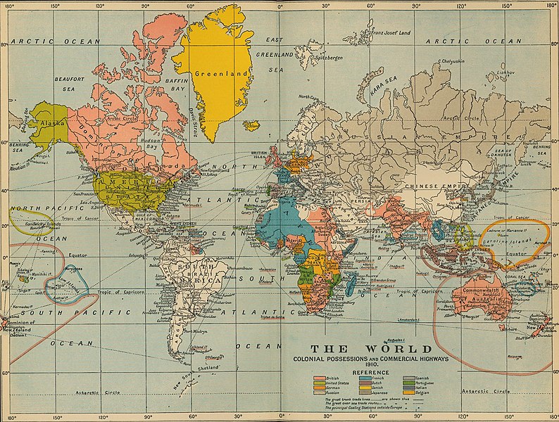
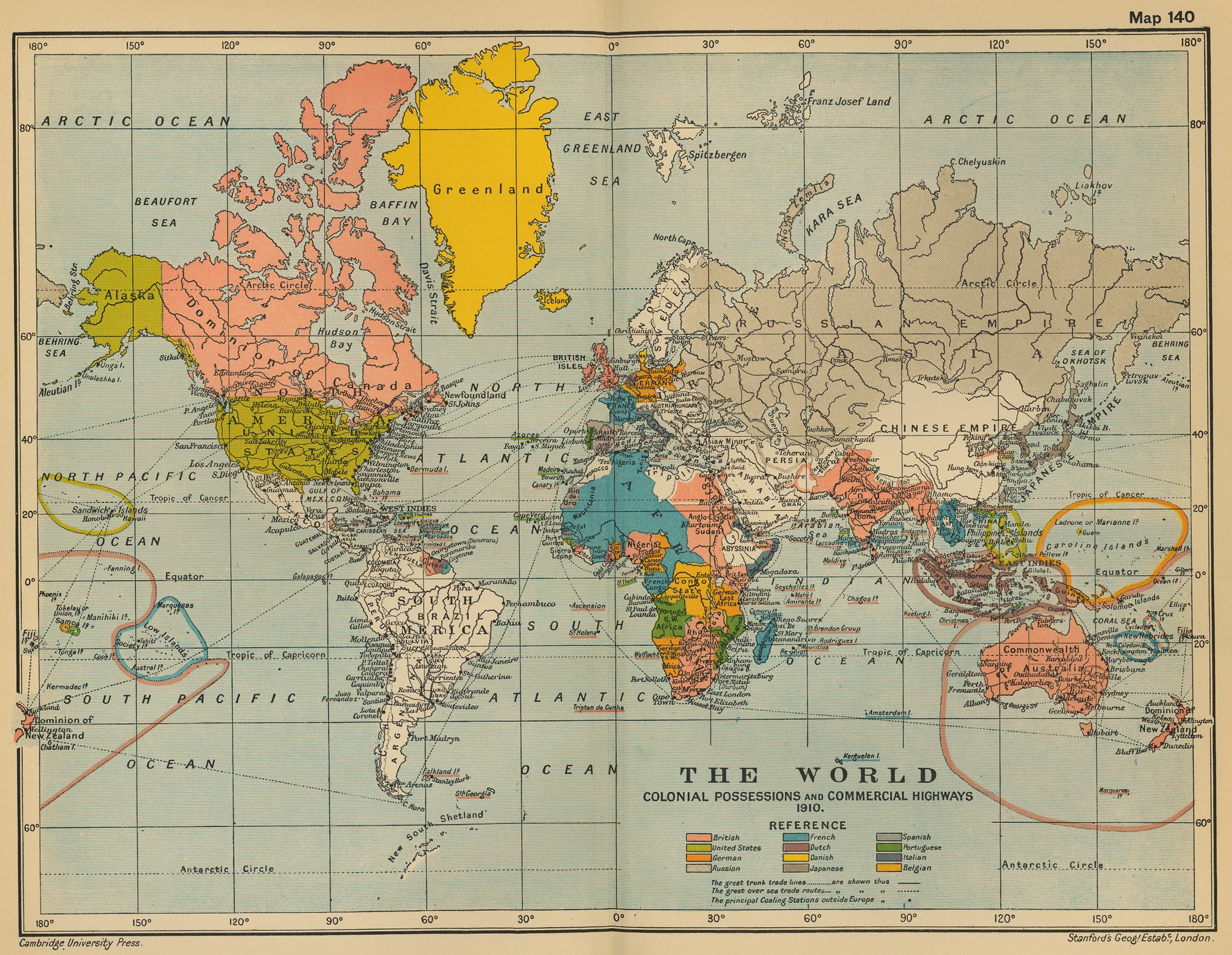
| تفصیل | The World: Colonial Possesions and Commercial Highways, 1910 |
| تریخ | |
| سروت |
University of Texas Libraries, Perry-Castañeda Library Map Collection: Historical Maps, Cambridge Modern History Atlas, 1912 |
| لکھاری | Edited by Sir Adolphus William Ward, G.W. Prothero, Sir Stanley Mordaunt Leathes, and E.A. Benians. |
لائسنس –
This work is in the public domain in the United States because it was published (or registered with the U.S. Copyright Office) before January 1, 1929.
Public domain works must be out of copyright in both the United States and in the source country of the work in order to be hosted on the Commons. If the work is not a U.S. work, the file must have an additional copyright tag indicating the copyright status in the source country.
Note: This tag should not be used for sound recordings. |
فائل دی تریخ
فائل نو اس ویلے دی حالت وچ ویکھن واسطے تاریخ/ویلے تے کلک کرو۔
| تریخ تے ویلہ | نکی مورت | پاسے | ورتن والا | تیپّݨی کرو | |
|---|---|---|---|---|---|
| موجودہ | ۲۱:۱۶, ۹ جولائی ۲۰۱۱ | | ۲,۱۲۴ × ۱,۶۰۵ (۱.۰۲ میگابائٹ) | Citypeek | turn and removal border |
| ۰۷:۳۱, ۲۰ جولائی ۲۰۰۶ |  | ۲,۲۰۱ × ۱,۷۰۵ (۹۷۱ کلوبائٹ) | Roke~commonswiki | from [http://www.lib.utexas.edu/maps/historical/ward_1912/world_1910.jpg] Perry-Castañeda Library Map Collection Cambridge Modern History Atlas, 1912 Category: Old maps |
فائل دی ورتوں
تھلے دتے گئے 3 صفحے اس فائل نال جُڑدے نیں
فائل ویاپک ورتوں
ایہہ دوجے وکیاں ایس فائل نوں ورتدے نیں –
- ar.wikipedia.org تے ورتوں
- as.wikipedia.org تے ورتوں
- de.wikipedia.org تے ورتوں
- en.wikipedia.org تے ورتوں
- fa.wikipedia.org تے ورتوں
- fr.wikipedia.org تے ورتوں
- he.wikiquote.org تے ورتوں
- hi.wikipedia.org تے ورتوں
- hr.wikipedia.org تے ورتوں
- it.wikipedia.org تے ورتوں
- pl.wikipedia.org تے ورتوں
- ta.wikipedia.org تے ورتوں
- th.wikipedia.org تے ورتوں
- uk.wikipedia.org تے ورتوں
- ur.wikipedia.org تے ورتوں
- vi.wikipedia.org تے ورتوں
- zh.wikipedia.org تے ورتوں