
فائل:Yorkshire and the Humber counties 2009 map.svg

Size of this PNG preview of this SVG file: ۷۰۵ × ۶۰۰ پکسلز. دوجے ریزولوشنز: ۲۸۲ × ۲۴۰ پکسلز | ۵۶۴ × ۴۸۰ پکسلز | ۹۰۳ × ۷۶۸ پکسلز | ۱,۲۰۴ × ۱,۰۲۴ پکسلز | ۲,۴۰۸ × ۲,۰۴۸ پکسلز | ۱,۴۲۵ × ۱,۲۱۲ پکسلز ۔
اصل فائل (ایس وی جی فائل، پکسل:۱,۴۲۵ × ۱,۲۱۲، فائل سائز: ۱.۲۵ میگابائٹ)
خلاصہ
| تفصیل |
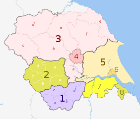
English: Map of the Yorkshire and the Humber region of England, showing its counties and administrative districts until 31 March 2023. The county colours are the same as those in File:English metropolitan and non-metropolitan counties 2009.svg.
For districts after 1 April 2023, see File:Yorkshire and the Humber counties 2023 map.svg. Equirectangular map projection on WGS 84 datum, with N/S stretched 170% Geographic limits:
|
| تریخ | (UTC) |
| سروت |
This file was derived from: |
| لکھاری |
|
| دوجے ورژن |
|

| Map | Ceremonial county | County / unitary | Districts |
|---|---|---|---|
 |
1. South Yorkshire * | a) Sheffield, b) Rotherham, c) Barnsley, d) Doncaster | |
| 2. West Yorkshire * | a) Wakefield, b) Kirklees, c) Calderdale, d) Bradford, e) Leeds | ||
| North Yorkshire (part only) |
3. North Yorkshire † | a) Selby, b) Harrogate, c) Craven, d) Richmondshire, e) Hambleton, f) Ryedale, g) Scarborough | |
| 4. York U.A. | |||
| East Riding of Yorkshire | 5. East Riding of Yorkshire U.A. | ||
| 6. Kingston upon Hull U.A. | |||
| Lincolnshire (part only) |
7. North Lincolnshire U.A. | ||
| 8. North East Lincolnshire U.A. | |||
Key: †shire county | *metropolitan county
لائسنس –
ایس فائل نوں کریٹو کامنز Attribution 2.5 پولینڈ لائسنس دتا گیا.
کس دے ناں: Dr Greg and Nilfanion. Contains Ordnance Survey data © Crown copyright and database right 2011
- تہانوں کھلھ اے:
- حصہ کرنا – کاپی، ونڈنا تے کم بھیجنا
- فیر رلانا – کم نوں فٹ کرنا
- تھلے دتیاں شرطاں نال:
- کس دے ناں – تسیں لازمی ایس کم دے بناں والے بارے دسو جنج اونے آکھیا اے یا جنج لسنس چ آکھیا گیا ہے۔
- اکو جہا شئیر کرو۔ – اگر تسیں بدلدے یا ایس کم تے بناندے تے بنن والے کم نوں اینج دے لسنس نال ای ونڈو گے۔
پہلا اپلوڈ دا ریکارڈ
This image is a derivative work of the following images:
- File:Yorkshire_and_the_Humber_districts_2011_map.svg licensed with Cc-by-sa-3.0, GFDL
- 2011-05-01T19:07:00Z Nilfanion 1425x1212 (1275424 Bytes) == Summary == {{Information |Description=Map of the [[w:Yorkshire and the Humber|Yorkshire and the Humber]] region showing the administrative districts. Equirectangular map projection on WGS 84 datum, with N/S stretched 170%
- File:English_ceremonial_counties_2010.svg licensed with Cc-by-sa-3.0, GFDL
- 2010-11-23T16:39:55Z Nilfanion 1108x1345 (308868 Bytes) thicker lines
- 2010-11-23T16:20:19Z Nilfanion 1108x1345 (301520 Bytes) tweaks
- 2010-10-26T20:34:20Z Nilfanion 817x990 (1391832 Bytes) {{Information |Description=Map showing the [[w:ceremonial counties of England]] including the City of London, in 2010. Equirectangular map projection on WGS 84 datum, with N/S stretched 170% Geographic limits: *West: 6.75W
Uploaded with derivativeFX
فائل دی تریخ
فائل نو اس ویلے دی حالت وچ ویکھن واسطے تاریخ/ویلے تے کلک کرو۔
| تریخ تے ویلہ | نکی مورت | پاسے | ورتن والا | تیپّݨی کرو | |
|---|---|---|---|---|---|
| موجودہ | ۰۲:۳۸, ۳ مئی ۲۰۱۲ | | ۱,۴۲۵ × ۱,۲۱۲ (۱.۲۵ میگابائٹ) | Dr Greg | == {{int:filedesc}} == {{Information |Description={{en|Map of the Yorkshire and the Humber region of England, showing its counties and administrative districts. The county colours are the same as those in [[:File:English ... |
فائل دی ورتوں
تھلے دتے گئے 1 صفحے اس فائل نال جُڑدے نیں
فائل ویاپک ورتوں
ایہہ دوجے وکیاں ایس فائل نوں ورتدے نیں –
- ar.wikipedia.org تے ورتوں
- bn.wikipedia.org تے ورتوں
- en.wikipedia.org تے ورتوں
- fa.wikipedia.org تے ورتوں
- frr.wikipedia.org تے ورتوں
- fr.wikipedia.org تے ورتوں
- hr.wikipedia.org تے ورتوں
- hu.wikipedia.org تے ورتوں
- mr.wikipedia.org تے ورتوں
- mzn.wikipedia.org تے ورتوں
- pl.wikipedia.org تے ورتوں
- pt.wikipedia.org تے ورتوں
- th.wikipedia.org تے ورتوں
- ur.wikipedia.org تے ورتوں
- vi.wikipedia.org تے ورتوں
- vls.wikipedia.org تے ورتوں
- zh-yue.wikipedia.org تے ورتوں