
فائل:Atilax paludinosus range map.png
اس توں وڈی مورت موجود نہیں۔
Atilax_paludinosus_range_map.png (۴۵۶ × ۴۷۳ پکسلز, فائل حجم: ۱۸ کلوبائٹ, MIME type: image/png)
خلاصہ
| تفصیل |
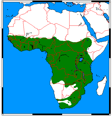
English: Range map for Marsh Mongoose (Atilax paludinosus), made by me with help of www.aquarius.geomar.de, Map depending on the range map at IUCN red list. |
| تریخ | |
| سروت | آپݨا کم |
| لکھاری | Udo Schröter |

|
This biogeographical map image could be re-created using vector graphics as an SVG file. This has several advantages; see Commons:Media for cleanup for more information. If an SVG form of this image is available, please upload it and afterwards replace this template with
{{vector version available|new image name}}.
It is recommended to name the SVG file “Atilax paludinosus range map.svg”—then the template Vector version available (or Vva) does not need the new image name parameter. |
لائسنس –
میں، اس کم دے کاپیرائٹ دا مالک، اس کم نوں اس لائسنس دے مطابق چھاپدا واں:
ایہ فائل ایس لسنس Creative Commons Attribution-Share Alike 3.0 Unported, 2.5 Generic, 2.0 Generic and 1.0 Generic نال چلدی اے۔
- تہانوں کھلھ اے:
- حصہ کرنا – کاپی، ونڈنا تے کم بھیجنا
- فیر رلانا – کم نوں فٹ کرنا
- تھلے دتیاں شرطاں نال:
- کس دے ناں – تسیں لازمی ایس کم دے بناں والے بارے دسو جنج اونے آکھیا اے یا جنج لسنس چ آکھیا گیا ہے۔
- اکو جہا شئیر کرو۔ – اگر تسیں بدلدے یا ایس کم تے بناندے تے بنن والے کم نوں اینج دے لسنس نال ای ونڈو گے۔

|
کاپی کرن، ونڈن تے بدلن دی ایس ڈوکومنٹ لئی اجازت دتی جاندی اے ایہناں GNU Free Documentation License, Version 1.2 شرطاں نال یا مگروں کسے وی چھپے ورین Free Software Foundation توں بنا کسے انویرینٹ سیکشن دے، ناں فرنٹ کور لکھت تے ناں بیک کور لکھت دے۔ لسنس دی اک کاپی سیکشن وچ ہیگی اے جہدا ناں اے GNU Free Documentation License۔ |
تسیں اپنی مرضی دا لائسنس چݨ سکدے اوہ۔
فائل دی تریخ
فائل نو اس ویلے دی حالت وچ ویکھن واسطے تاریخ/ویلے تے کلک کرو۔
| تریخ تے ویلہ | نکی مورت | پاسے | ورتن والا | تیپّݨی کرو | |
|---|---|---|---|---|---|
| موجودہ | ۰۶:۰۷, ۱۸ مارچ ۲۰۱۸ | | ۴۵۶ × ۴۷۳ (۱۸ کلوبائٹ) | Maphobbyist | Border updates: South Sudan, Eritrea and Lebanon added, Yemen united, the former Neutral Zone and Waalvisbai removed, and all border gaps filled. |
| ۰۳:۵۱, ۱۷ مارچ ۲۰۱۸ |  | ۳۳۳ × ۳۶۳ (۱۴ کلوبائٹ) | Maphobbyist | South Sudan border | |
| ۲۳:۳۰, ۲۸ جولائی ۲۰۱۱ |  | ۲۹۴ × ۳۴۱ (۱۹ کلوبائٹ) | Craig Pemberton | Crop to original size. | |
| ۲۳:۳۰, ۲۸ جولائی ۲۰۱۱ |  | ۳۷۹ × ۴۵۰ (۲۵ کلوبائٹ) | Craig Pemberton | Normalize with other range maps for eventual combination in parent taxa. | |
| ۱۸:۵۰, ۲۴ اپریل ۲۰۰۹ |  | ۴۵۶ × ۴۷۳ (۲۰ کلوبائٹ) | Nordelch | {{Information |Description={{en|1=Range map for Marsh Mongoose (''Atilax paludinosus''), made by me with help of [http://www.aquarius.geomar.de/omc_intro.html www.aquarius.geomar.de], Map depending on the [http://www.iucnredlist.org/details/41590 range ma |
فائل دی ورتوں
تھلے دتے گئے 1 صفحے اس فائل نال جُڑدے نیں
فائل ویاپک ورتوں
ایہہ دوجے وکیاں ایس فائل نوں ورتدے نیں –
- af.wikipedia.org تے ورتوں
- ar.wikipedia.org تے ورتوں
- arz.wikipedia.org تے ورتوں
- avk.wikipedia.org تے ورتوں
- azb.wikipedia.org تے ورتوں
- bg.wikipedia.org تے ورتوں
- br.wikipedia.org تے ورتوں
- ca.wikipedia.org تے ورتوں
- ceb.wikipedia.org تے ورتوں
- de.wikipedia.org تے ورتوں
- el.wikipedia.org تے ورتوں
- en.wikipedia.org تے ورتوں
- es.wikipedia.org تے ورتوں
- eu.wikipedia.org تے ورتوں
- fa.wikipedia.org تے ورتوں
- fr.wikipedia.org تے ورتوں
- he.wikipedia.org تے ورتوں
- hu.wikipedia.org تے ورتوں
- id.wikipedia.org تے ورتوں
- it.wikipedia.org تے ورتوں
- ko.wikipedia.org تے ورتوں
- mhr.wikipedia.org تے ورتوں
- pl.wikipedia.org تے ورتوں
- ru.wikipedia.org تے ورتوں
- sq.wikipedia.org تے ورتوں
- sv.wikipedia.org تے ورتوں
- tr.wikipedia.org تے ورتوں
- uk.wikipedia.org تے ورتوں
- vi.wikipedia.org تے ورتوں
- www.wikidata.org تے ورتوں
- zh.wikipedia.org تے ورتوں